NAME
v.rast.move - Move vertices by distance specified in a rasterKEYWORDS
vector, transformation, geometry, raster, linesSYNOPSIS
v.rast.move
v.rast.move --helpv.rast.move input=name x_raster=name y_raster=name [nulls=string] output=name [--overwrite] [--help] [--verbose] [--quiet] [--ui]
Flags:
- --overwrite
- Allow output files to overwrite existing files
- --help
- Print usage summary
- --verbose
- Verbose module output
- --quiet
- Quiet module output
- --ui
- Force launching GUI dialog
Parameters:
- input=name [required]
- Name of input vector map
- Or data source for direct OGR access
- x_raster=name [required]
- Name of input raster map
- y_raster=name [required]
- Name of input raster map
- nulls=string
- Handling of null values
- zeros;Null value will be converted to zeros;warning;A null value will cause a warning (one for each raster) and will be converted to zero;error;A null value will cause an error
- Options: zeros, warning, error
- Default: warning
- output=name [required]
- Name for output vector map
Table of contents
DESCRIPTION
v.rast.move takes values from raster maps and adds them to X and Y coordinates of features in a vector map vertex by vertex. Works on lines only, other features are ignored and not included in the result. Null values in rasters are turned into zeros by default and a warning is generated. This behavior can be modified by the nulls option to either silence the warning with explicitnulls="zeros"
or the warning can be turned into an error with nulls="error".
The rasters are loaded based on the computational region, so the most
advantageous use of resources is to set the computational region to
match the vector. To avoid issues with vector coordinates at the border
of the computational region, it is best to also grow the region one cell
on each side. Vector features outside of the computational region always
result in an error being reported (regardless of the nulls option),
but the rasters can have any extent as along as the computational region
is set to match the vector.
NOTES
Unlike v.perturb which moves points randomly, v.rast.move works on vertices of lines and uses same value for all vertices at a given cell. Unlike v.transform used with raster values in attribute columns, v.rast.move operates on individual vertices in the line, not on the whole line (attributes are associated with features, not their vertices).EXAMPLES
Shift in X direction
This example uses the North Carolina sample dataset. Set the computational region to match the vector map and use 100-meter resolution.g.region vector=roadsmajor res=100
g.region vector=roadsmajor res=100
r.mapcalc expression="a = 1000 * sin(row())"
r.mapcalc expression="b = 0"
v.rast.move input=roadsmajor output=roads_moved x_raster=a y_raster=b
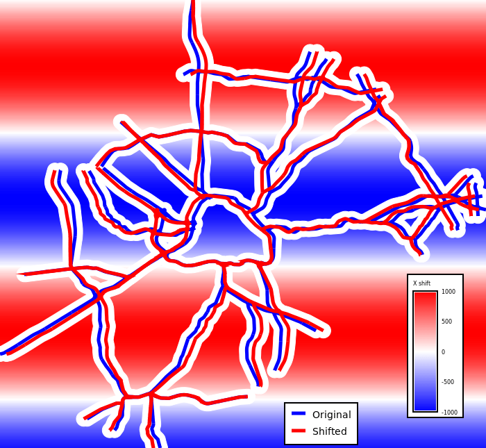
Figure: Original (blue) and shifted (red) road network and the X shift values in diverging blue-white-red colors (red shift right, blue shift left, white no shift)
SEE ALSO
- v.transform for changing coordinates for the whole vector map or feature by feature based on the attributes,
- v.perturb for randomly changing point positions by small amounts,
- r.mapcalc for generating or adjusting the raster maps,
- g.region to set the computational region before the computation.
AUTHOR
Vaclav Petras, NCSU Center for Geospatial Analytics, GeoForAll LabSOURCE CODE
Available at: v.rast.move source code (history)
Latest change: Thursday Nov 09 12:13:34 2023 in commit: fc9c34d4c5fe79186dc55a80e1340382c2957971
Main index | Vector index | Topics index | Keywords index | Graphical index | Full index
© 2003-2024 GRASS Development Team, GRASS GIS 8.3.3dev Reference Manual