Set-up your location
To specify your new location gather out the following information:
coordinate system for your project area (plane or with projection and ellipsoid)
minimum and maximum coordinates of the area of interest
ground resolution
The supported common coordinate systems are here.
In general, planning of a database in a Geographical Information System requires some preparation. The user should proceed with care, since the chosen data structure determines the usability of the GIS. Special attention should be accorded to the resolution -- a high raster resolution requires large calculation and memory capacities, a low raster resolution rarely provides acceptable results (this resolution issue is not relevant for vector and sites data). The optimum is somewhere in between and depends on the needs, but also a lot on the input data quality.
The main procedure for creating a location is as follows: first, the GRASS "startup screen" appears. If you started up GRASS with grass5 -text (or if this is the first time you start GRASS), the text interface will come up:
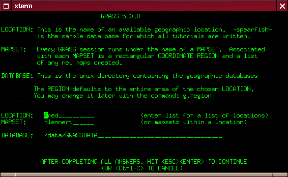
There the names of the location (i.e. the entire project area) and the mapset as well as the path to the database need to be entered (e.g. /home/jack/grassdata).
If you enter list in one line and then press ESC - RETURN to leave this startup mask, GRASS lists all the data available in this category, i.e. all available locations or mapsets. Once you have entered the location, the mapset and the GRASS database, you can continue with ESC-RETURN. In order to create a new location, just enter a non-existing location name, and GRASS will ask you if you would like to create a new location.
If you startup GRASS with grass5 -tcltk), you will see the following screen:
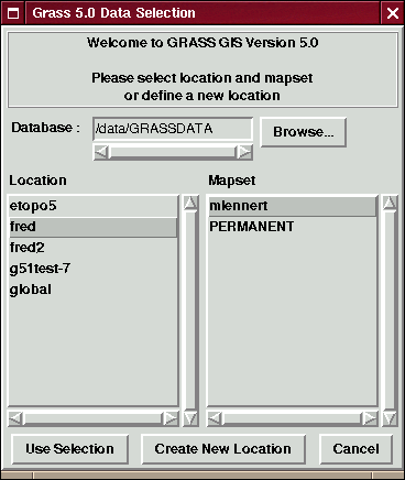
Click on the button "Create New Location" which will get to the above text screen on which you can enter a non-existing location name and continue with ESC-RETURN.
Now, you need to attribute different parameters to the location, such as the coordinate system you want to use, including the ellipsoid, the coordinates of the boundaries of the project area and the default resolution for raster data:
Start out by chosing between, x,y, Latitude-Longitude, UTM or another coordinate system. This choice depends on your data and the use will make of it.
Now one line describing the project area, for example "Topo Map of the Alps"
Now some more information about the projection follows. Note that the prompts vary from projection to projection:
(if you chose "D - Other Projection") "specify projection name": "list" gives you the list of all available projections, examples are "tmerc" for Transverse Mercator, "lcc" for Lambert Conformal Conic, "moll" for Mollweide, etc.
specify ellipsoid name}: again use "list" to get a list of available ellipsoids, examples are "sphere", "clark80", "wgs84", etc.
if you want, you can specify a datum, again use "list" for available options
Enter Central Parallel: 0 if you want the Equator as the central parallel
Enter Central Meridian: 0 if you want the Greenwich meridian as central meridian
Enter Scale Factor at the Central Meridian}
Enter False Easting
Enter plural form of units: for example, meters
Next is the description of the boundary coordinates of the project area and the definition of the default raster resolution:
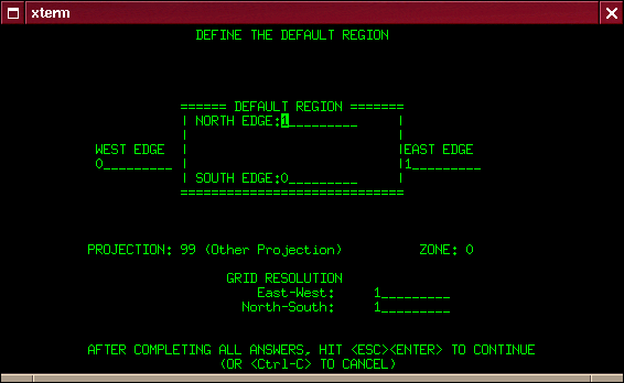
The default raster resolution (GRID RESOLUTION) has to be chosen according to the needs. Generally, it is advisable to work in steps of 0.25 (0.25, 0.5, 1.75, 2.00, 12.25 etc.). This resolution does not concern vector and site data since these are stored with their exact coordinate values. Note that every raster map may have its own resolution. You can leave this screen with ``ESC''-``RETURN'' and then accept the list of parameters that appears, if everything is correct.
You will get back to the startup screen again to enter the mapset's name (if not already entered). Another ``ESC''-``RETURN'' will finally let you leave this screen. This mapset is created within the new location by answering ``yes'' to the next question. The mapset will use the parameters of the location (such as the region and resolution definitions) as its default parameters.
Now the project area, i.e. the location including a mapset has been created. You have "arrived" in the GRASS system and can start working within this new location.