v.centerline
Creates a central line of a map of lines
v.centerline [-tm] input=name output=name [range=float] [refline=integer] [vertices=integer] [--overwrite] [--verbose] [--quiet] [--qq] [--ui]
Example:
v.centerline input=name output=name
grass.tools.Tools.v_centerline(input, output, range=None, refline=None, vertices=20, flags=None, overwrite=None, verbose=None, quiet=None, superquiet=None)
Example:
tools = Tools()
tools.v_centerline(input="name", output="name")
This grass.tools API is experimental in version 8.5 and expected to be stable in version 8.6.
grass.script.run_command("v.centerline", input, output, range=None, refline=None, vertices=20, flags=None, overwrite=None, verbose=None, quiet=None, superquiet=None)
Example:
gs.run_command("v.centerline", input="name", output="name")
Parameters
input=name [required]
Name of input vector map
Or data source for direct OGR access
output=name [required]
Name for output vector map
range=float
Distance (in map units) of search radius
refline=integer
Category of the line to use as initial reference
vertices=integer
Number of vertices for center line
Default: 20
-t
Use transversal line algorithm
-m
Use approximate median instead of mean
--overwrite
Allow output files to overwrite existing files
--help
Print usage summary
--verbose
Verbose module output
--quiet
Quiet module output
--qq
Very quiet module output
--ui
Force launching GUI dialog
input : str, required
Name of input vector map
Or data source for direct OGR access
Used as: input, vector, name
output : str, required
Name for output vector map
Used as: output, vector, name
range : float, optional
Distance (in map units) of search radius
refline : int, optional
Category of the line to use as initial reference
vertices : int, optional
Number of vertices for center line
Default: 20
flags : str, optional
Allowed values: t, m
t
Use transversal line algorithm
m
Use approximate median instead of mean
overwrite : bool, optional
Allow output files to overwrite existing files
Default: None
verbose : bool, optional
Verbose module output
Default: None
quiet : bool, optional
Quiet module output
Default: None
superquiet : bool, optional
Very quiet module output
Default: None
Returns:
result : grass.tools.support.ToolResult | None
If the tool produces text as standard output, a ToolResult object will be returned. Otherwise, None will be returned.
Raises:
grass.tools.ToolError: When the tool ended with an error.
input : str, required
Name of input vector map
Or data source for direct OGR access
Used as: input, vector, name
output : str, required
Name for output vector map
Used as: output, vector, name
range : float, optional
Distance (in map units) of search radius
refline : int, optional
Category of the line to use as initial reference
vertices : int, optional
Number of vertices for center line
Default: 20
flags : str, optional
Allowed values: t, m
t
Use transversal line algorithm
m
Use approximate median instead of mean
overwrite : bool, optional
Allow output files to overwrite existing files
Default: None
verbose : bool, optional
Verbose module output
Default: None
quiet : bool, optional
Quiet module output
Default: None
superquiet : bool, optional
Very quiet module output
Default: None
DESCRIPTION
v.centerline creates a new map with a line representing an approximation of the central tendency of a series of input lines that all have similar trajectories. This can for example, be the central line of a river represented by its two sides, or a line representing the general direction of a series of flight paths, etc.
Two algorithms are proposed in the module, both based on the idea of using a reference line, creating a series of reference points along this line and then finding the coordinates of corresponding points on all the input lines. The default algorithm uses closest distance to identify corresponding points, while the second algorithm (t flag) draws perpendicular transversals at the reference points and uses the intersections of these transversals with the other lines as corresponding points.
In detail, the default algorithm goes as follows:
- choose one of the input lines as reference line
- create a series of points at regular intervals on this line
- for each of these points:
- find the closest point on each of the input lines
- get the coordinates of those points
- calculate the mean or (mathematical) median of these coordinates
- use the calculated means (or medians) as vertices of the new line
The transversals algorithm goes as follows:
- choose one of the input lines as reference line
- create a series of perpendicular (transversal) lines at regular intervals on this line
- for each of these transversals:
- find the intersection points of the transversal with all input lines
- get the coordinates of those points
- calculate the mean or (mathematical) median of these coordinates
- use the calculated means (or medians) as vertices of the new line
The user can change three parameters in the algorithms: the choice of the reference line (refline), the number of vertices to calculate (vertices) and the search range (range), i.e. for the default algorithm the maximum distance of corresponding points from the reference line and for the second algorithm the length of the transversals on each side of the reference line.
If no reference line is given the module choses the reference line by determining the mean distance of the midpoint of each line to the midpoints of all other lines. The line with the lowest mean distance is then chosen as the reference line. If no range is given, the module uses the mean of the above mean distances as the range for the transversals algorithm, and an unlimited search range for the default algorithm.
If the m flag is set and there are more than 2 lines in the input file, the module calculates the mathematical median of the x and of the y coordinates.
NOTES
This module is more of a proof of concept showing that an approximate solution to the problem is possible with existing GRASS modules. A C-based solution would probably be much more efficient.
The median in this module is not the geometric median, but the simple mathematical median respectively of the x and the y coordinates.
The transversals algorithm is very sensitive to the range parameter. The user might want to play around with this parameter to find the best value.
Increasing the number of vertices should have a smoothing effect on the resulting line, but in the case of the transversals algorithm it can possibly lead to more instability.
EXAMPLE
v.centerline input=flightpaths output=center_line_mean
v.centerline -m input=flightpaths output=center_line_median
v.centerline input=flightpaths output=center_line_mean_5000 range=5000
v.centerline -t input=flightpaths output=center_line_mean_t
v.centerline -t input=flightpaths output=center_line_mean_t_8000 range=8000
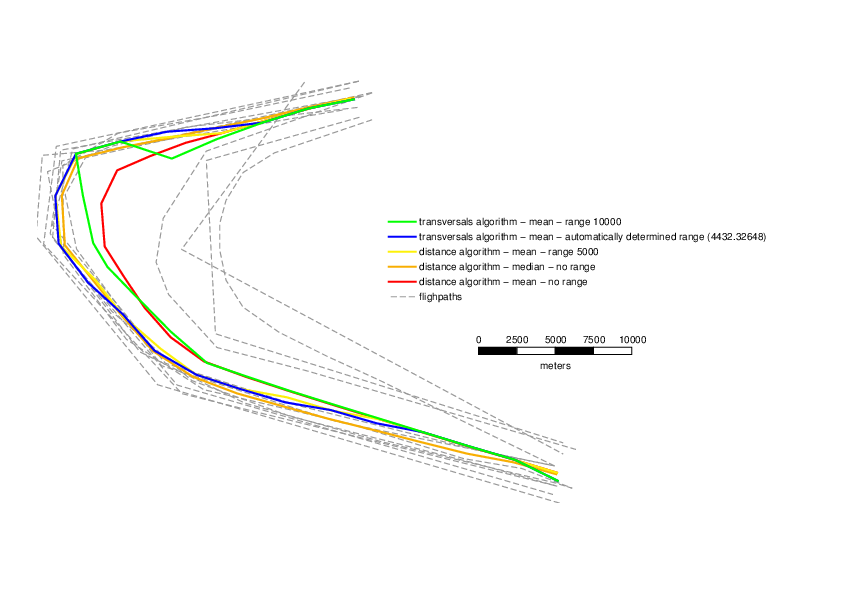
Different centerlines resulting from variations in the parameters and
flags
v.centerline input=river output=center_line
v.centerline -t input=river output=river_center_t
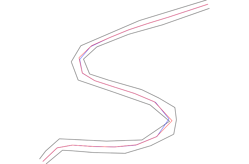
Mean central line (median only makes sense if number of lines > 2) for
distance (red) and transversals (blue) algorithms, the latter with
automatically determined range
SEE ALSO
v.segment,
v.distance
Similar addons: v.centerpoint
AUTHOR
Moritz Lennert
SOURCE CODE
Available at: v.centerline source code
(history)
Latest change: Tuesday Feb 17 14:54:26 2026 in commit 051b9c1