NAME
v.transects - Creates transect lines or quadrilateral areas at regular intervals perpendicular to a polyline.KEYWORDS
vector, transectSYNOPSIS
Flags:
- -l
- Use the last point of the line to create transect
- --overwrite
- Allow output files to overwrite existing files
- --help
- Print usage summary
- --verbose
- Verbose module output
- --quiet
- Quiet module output
- --ui
- Force launching GUI dialog
Parameters:
- input=name [required]
- Name of input vector map
- Or data source for direct OGR access
- output=name [required]
- Name for output vector map
- transect_spacing=float [required]
- Transect spacing along input polyline
- dleft=float
- Distance transect extends to the left of input line
- Default is the same as the transect spacing
- dright=float
- Distance transect extends to the right of input line
- Default is the same as the transect spacing
- type=string
- Output type
- Input feature type
- Options: point, line, area
- Default: line
- metric=string
- Determines how transect spacing is measured
- Options: straight, along
- Default: straight
- straight: Straight distance between transect points
- along: Distance along the line
- transect_perpendicular=string
- Determines which line is the transect perpendicular to
- Options: trend, line
- Default: trend
- trend: Perpendicular to the line connecting transect points
- line: Perpendicular to the particular segment of the original line
Table of contents
DESCRIPTION
v.transects creates equally spaced geometries along input lines. Depending on the selected metric, the distances are measured either as straight distances between the transects or along the line. Straight distance is better when the lines are complicated (shorelines) and using the distance along line would result in big differences in the transect spacing.The geometries can be lines or quadrilateral areas. Lines and areas are generated to be perpendicular to either the input line (select line for parameter transect_perpendicular), or to the line connecting the transect points (select trend for parameter transect_perpendicular). The latter option is useful for complicated lines, because it follows the trend of the line.
By default the last point of each line is not used because the last transect distance would be typically different from the previous once. To create a transect from the last point, use flag -l.
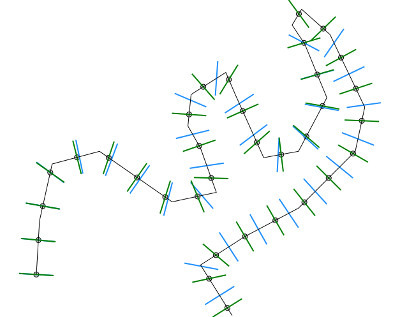
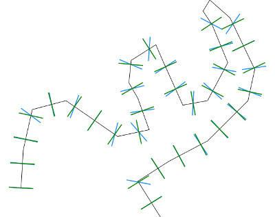
The following pictures show the effect of different options on a line with simple geometry.
In the first picture, the circles show points generated by v.segment
in 100 m interval along the line. The green lines were generated with option
metric=along, therefore they match with the points. The blue lines
were generated with metric=straight.
In the second picture, green lines use transect_perpendicular=line
while the blue ones use transect_perpendicular=trend.


NOTES
Input vector lines that are shorter than transect_spacing are ignored.transect_spacing, dleft, and dright are interpreted to be in horizontal map units (e.g., degrees in the LatLong/WGS84 coordinate system).
v.transects may fail for a network of lines in Windows.
The categories of the input lines are stored in layer 2 of the output. To upload them
to the transects table, use v.to.db like this:
v.transects input=lines output=transects transect_spacing=100
v.db.addtable transects columns="line_cat"
v.db.addtable transects layer=2
v.to.db transects query_layer=2 query_column=cat option=query column=line_cat
EXAMPLES
In these examples, the Nags Head (19MB) mapset is used to generate a shoreline and shore-perpendicular geometries. To use the mapset, unpack it into the nc_spm_08_grass7 (50MB) location.Example 1) - Generate line transects along shoreline
Generate 20 cross-shore transects along 2008 shoreline (1m contour)
g.region raster=NH_2008_1m
r.contour input=NH_2008_1m output=NH_2008_1m level=1 cut=100
v.report map=NH_2008_1m option=length
# cat|level|length
# 1|1|1037.86684790028
# 1038m / 20transects = 52m per transect (value for transect_spacing)
v.transects input=NH_2008_1m output=NH_2008_transects transect_spacing=52
v.info NH_2008_transects
Example 2) - Generate line transects specifying the left and right length
Generate longer, more parallel transects by specifying dleft and dright and
smoothing the input line
g.region raster=NH_2008_1m
r.contour input=NH_2008_1m output=NH_2008_1m level=1 cut=100
v.generalize input=NH_2008_1m output=NH_2008_1m_smoothed \
  method=sliding_averaging look_ahead=201
v.transects input=NH_2008_1m_smoothed \
  output=NH_2008_transects_long_smoothed transect_spacing=52 \
  dleft=20 dright=300
Example 3) - Generate area transects along shoreline
Generate longer, more parallel transects by specifying dleft and dright and
smoothing the input line
g.region raster=NH_2008_1m
r.contour input=NH_2008_1m output=NH_2008_1m level=1 cut=100
v.transects input=NH_2008_1m output=NH_2008_areas \
  transect_spacing=52 dleft=20 dright=300 type=area
v.db.addtable NH_2008_areas
v.db.addcolumn map=NH_2008_areas columns='demStats DOUBLE PRECISION'
v.rast.stats vector=NH_2008_areas raster=NH_2008_1m column_prefix=NH2008
v.db.select NH_2008_areas
SEE ALSO
v.segmentv.generalize
v.transects tutorial
AUTHORS
Eric Hardin, Helena Mitasova, Updates by John LloydSOURCE CODE
Available at: v.transects source code (history)
Latest change: Tuesday Feb 17 14:54:26 2026 in commit: 051b9c19442e746e2b51f9c5382809a45230b4c0
Main index | Vector index | Topics index | Keywords index | Graphical index | Full index
© 2003-2025 GRASS Development Team, GRASS GIS 8.4.3dev Reference Manual