d.to.rast
Saves the contents of the active display monitor to a raster map.
d.to.rast output=name [--overwrite] [--verbose] [--quiet] [--qq] [--ui]
Example:
d.to.rast output=name
grass.tools.Tools.d_to_rast(output, overwrite=None, verbose=None, quiet=None, superquiet=None)
Example:
tools = Tools()
tools.d_to_rast(output="name")
This grass.tools API is experimental in version 8.5 and expected to be stable in version 8.6.
grass.script.run_command("d.to.rast", output, overwrite=None, verbose=None, quiet=None, superquiet=None)
Example:
gs.run_command("d.to.rast", output="name")
Parameters
output=name [required]
Name for output raster map
--overwrite
Allow output files to overwrite existing files
--help
Print usage summary
--verbose
Verbose module output
--quiet
Quiet module output
--qq
Very quiet module output
--ui
Force launching GUI dialog
output : str | type(np.ndarray) | type(np.array) | type(gs.array.array), required
Name for output raster map
Used as: output, raster, name
overwrite : bool, optional
Allow output files to overwrite existing files
Default: None
verbose : bool, optional
Verbose module output
Default: None
quiet : bool, optional
Quiet module output
Default: None
superquiet : bool, optional
Very quiet module output
Default: None
Returns:
result : grass.tools.support.ToolResult | np.ndarray | tuple[np.ndarray] | None
If the tool produces text as standard output, a ToolResult object will be returned. Otherwise, None will be returned. If an array type (e.g., np.ndarray) is used for one of the raster outputs, the result will be an array and will have the shape corresponding to the computational region. If an array type is used for more than one raster output, the result will be a tuple of arrays.
Raises:
grass.tools.ToolError: When the tool ended with an error.
output : str, required
Name for output raster map
Used as: output, raster, name
overwrite : bool, optional
Allow output files to overwrite existing files
Default: None
verbose : bool, optional
Verbose module output
Default: None
quiet : bool, optional
Quiet module output
Default: None
superquiet : bool, optional
Very quiet module output
Default: None
DESCRIPTION
d.to.rast saves the content of the currently selected monitor into a raster map. The active monitor can be selected with d.mon. d.to.rast can be run from GUI Console tab, too. This module is not sensitive to computational region settings.
EXAMPLE
We combine different raster and vector map layers to create a composite layer which can be draped over elevation in 3D view. First, we add a couple of maps to layer manager:
g.region raster=elevation
d.rast map=elevation
d.rast map=lakes
d.vect map=roadsmajor width=4
d.vect map=roadsmajor width=2 color=yellow

# create a raster map from the display
d.to.rast output=composite
Then uncheck all layers except for elevation and switch to 3D view. In Data tab, set color map to the newly created composite map.
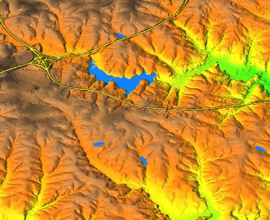 Figure: Raster map created by d.to.rast draped over digital elevation model.
SEE ALSO
d.out.file, d.erase, d.rast, d.vect, d.mon
AUTHOR
Anna Petrasova, NCSU GeoForAll Lab
SOURCE CODE
Available at: d.to.rast source code
(history)
Latest change: Thursday Feb 20 12:48:50 2025 in commit 1633be4