v.to.rast
Converts (rasterize) a vector map into a raster map.
v.to.rast [-d] input=name [layer=string] [type=string [,string,...]] [cats=range] [where=sql_query] output=name use=string [attribute_column=name] [rgb_column=name] [label_column=name] [value=float] [memory=memory in MB] [--overwrite] [--verbose] [--quiet] [--qq] [--ui]
Example:
v.to.rast input=name output=name use=attr
grass.tools.Tools.v_to_rast(input, layer="1", type="point,line,area", cats=None, where=None, output, use, attribute_column=None, rgb_column=None, label_column=None, value=1, memory=300, flags=None, overwrite=None, verbose=None, quiet=None, superquiet=None)
Example:
tools = Tools()
tools.v_to_rast(input="name", output="name", use="attr")
This grass.tools API is experimental in version 8.5 and expected to be stable in version 8.6.
grass.script.run_command("v.to.rast", input, layer="1", type="point,line,area", cats=None, where=None, output, use, attribute_column=None, rgb_column=None, label_column=None, value=1, memory=300, flags=None, overwrite=None, verbose=None, quiet=None, superquiet=None)
Example:
gs.run_command("v.to.rast", input="name", output="name", use="attr")
Parameters
input=name [required]
Name of input vector map
Or data source for direct OGR access
layer=string
Layer number or name
Vector features can have category values in different layers. This number determines which layer to use. When used with direct OGR access this is the layer name.
Default: 1
type=string [,string,...]
Input feature type
Allowed values: point, line, boundary, centroid, area
Default: point,line,area
cats=range
Category values
Example: 1,3,7-9,13
where=sql_query
WHERE conditions of SQL statement without 'where' keyword
Example: income < 1000 and population >= 10000
output=name [required]
Name for output raster map
use=string [required]
Source of raster values
Allowed values: attr, cat, value, z, dir
attr: read values from attribute table
cat: use category values
value: use value specified by value option
z: use z coordinate (points or contours only)
dir: line direction in degrees CCW from east (lines only)
attribute_column=name
Name of column for 'attr' parameter (data type must be numeric)
rgb_column=name
Name of color definition column (with RRR:GGG:BBB entries)
label_column=name
Name of column used as raster category labels
value=float
Raster value (for use=value)
Default: 1
memory=memory in MB
Maximum memory to be used (in MB)
Cache size for raster rows
Default: 300
-d
Create densified lines (default: thin lines)
All cells touched by the line will be set, not only those on the render path
--overwrite
Allow output files to overwrite existing files
--help
Print usage summary
--verbose
Verbose module output
--quiet
Quiet module output
--qq
Very quiet module output
--ui
Force launching GUI dialog
input : str, required
Name of input vector map
Or data source for direct OGR access
Used as: input, vector, name
layer : str, optional
Layer number or name
Vector features can have category values in different layers. This number determines which layer to use. When used with direct OGR access this is the layer name.
Used as: input, layer
Default: 1
type : str | list[str], optional
Input feature type
Allowed values: point, line, boundary, centroid, area
Default: point,line,area
cats : str, optional
Category values
Example: 1,3,7-9,13
Used as: input, cats, range
where : str, optional
WHERE conditions of SQL statement without 'where' keyword
Example: income < 1000 and population >= 10000
Used as: input, sql_query, sql_query
output : str | type(np.ndarray) | type(np.array) | type(gs.array.array), required
Name for output raster map
Used as: output, raster, name
use : str, required
Source of raster values
Allowed values: attr, cat, value, z, dir
attr: read values from attribute table
cat: use category values
value: use value specified by value option
z: use z coordinate (points or contours only)
dir: line direction in degrees CCW from east (lines only)
attribute_column : str, optional
Name of column for 'attr' parameter (data type must be numeric)
Used as: input, dbcolumn, name
rgb_column : str, optional
Name of color definition column (with RRR:GGG:BBB entries)
Used as: input, dbcolumn, name
label_column : str, optional
Name of column used as raster category labels
Used as: input, dbcolumn, name
value : float, optional
Raster value (for use=value)
Default: 1
memory : int, optional
Maximum memory to be used (in MB)
Cache size for raster rows
Used as: memory in MB
Default: 300
flags : str, optional
Allowed values: d
d
Create densified lines (default: thin lines)
All cells touched by the line will be set, not only those on the render path
overwrite : bool, optional
Allow output files to overwrite existing files
Default: None
verbose : bool, optional
Verbose module output
Default: None
quiet : bool, optional
Quiet module output
Default: None
superquiet : bool, optional
Very quiet module output
Default: None
Returns:
result : grass.tools.support.ToolResult | np.ndarray | tuple[np.ndarray] | None
If the tool produces text as standard output, a ToolResult object will be returned. Otherwise, None will be returned. If an array type (e.g., np.ndarray) is used for one of the raster outputs, the result will be an array and will have the shape corresponding to the computational region. If an array type is used for more than one raster output, the result will be a tuple of arrays.
Raises:
grass.tools.ToolError: When the tool ended with an error.
input : str, required
Name of input vector map
Or data source for direct OGR access
Used as: input, vector, name
layer : str, optional
Layer number or name
Vector features can have category values in different layers. This number determines which layer to use. When used with direct OGR access this is the layer name.
Used as: input, layer
Default: 1
type : str | list[str], optional
Input feature type
Allowed values: point, line, boundary, centroid, area
Default: point,line,area
cats : str, optional
Category values
Example: 1,3,7-9,13
Used as: input, cats, range
where : str, optional
WHERE conditions of SQL statement without 'where' keyword
Example: income < 1000 and population >= 10000
Used as: input, sql_query, sql_query
output : str, required
Name for output raster map
Used as: output, raster, name
use : str, required
Source of raster values
Allowed values: attr, cat, value, z, dir
attr: read values from attribute table
cat: use category values
value: use value specified by value option
z: use z coordinate (points or contours only)
dir: line direction in degrees CCW from east (lines only)
attribute_column : str, optional
Name of column for 'attr' parameter (data type must be numeric)
Used as: input, dbcolumn, name
rgb_column : str, optional
Name of color definition column (with RRR:GGG:BBB entries)
Used as: input, dbcolumn, name
label_column : str, optional
Name of column used as raster category labels
Used as: input, dbcolumn, name
value : float, optional
Raster value (for use=value)
Default: 1
memory : int, optional
Maximum memory to be used (in MB)
Cache size for raster rows
Used as: memory in MB
Default: 300
flags : str, optional
Allowed values: d
d
Create densified lines (default: thin lines)
All cells touched by the line will be set, not only those on the render path
overwrite : bool, optional
Allow output files to overwrite existing files
Default: None
verbose : bool, optional
Verbose module output
Default: None
quiet : bool, optional
Quiet module output
Default: None
superquiet : bool, optional
Very quiet module output
Default: None
DESCRIPTION
v.to.rast transforms GRASS vector map layers into GRASS raster map layer format. Optionally, attributes can be converted to raster category labels.
NOTES
In order to avoid unexpected results, the type of vector features should always be specified. The default is to convert all vector features, but if only e.g. areas should be converted use type=area rather than type=point,line,area.
v.to.rast will only affect data in areas lying inside the boundaries of the current geographic region. A grid cell belongs to the area where the grid cell center falls into.
Before running v.to.rast, the user should therefore ensure that the current geographic region is correctly set and that the region resolution is at the desired level.
Either the column parameter or the value parameter must be specified. The use option may be specified alone when using the dir option.
use options are:
- attr - read values from attribute table (default)
- cat - read values from category
- value - use value specified by value option
- z - use z coordinate (points or contours only)
- dir - line direction in degrees counterclockwise from east (lines only)
The column parameter uses an existing column from the vector map database table as the category value in the output raster map. Existing table columns can be shown by using db.describe.
An empty raster map layer will be created if the vector map layer has not been assigned category/attribute labels (e.g., through use of v.category option=add).
Otherwise:
- Labeled areas and/or centroids will produce filled raster coverages
with edges that straddle the original area boundary as long as the
boundary is NOT labeled.
(Usev.category option=del type=boundaryto remove.) - Labeled lines and boundaries will produce lines of raster cells which touch the original vector line. This tends to be more aggressive than area-only conversions.
- Points and orphaned centroids will be converted into single cells on the resultant raster map.
Line directions are given in degrees counterclockwise from east.
Raster category labels are supported for all of use= except use=z.
The -d flag applies only to lines and boundaries, the default is to set only those cells on the render path (thin line).
Boundaries (usually without categories) can be rasterized with
v.to.rast type=boundary layer=-1 use=value
EXAMPLES
Convert a vector map and use column SPEED from attribute table
db.describe -c table=vect_map

ncols:3
Column 1: CAT
Column 2: SPEED
Column 3: WIDTH
v.to.rast input=vect_map output=raster_map attribute_column=SPEED type=line
Calculate stream directions from a river vector map (Spearfish)
v.to.rast input=streams output=streamsdir use=dir
Calculate slope along path
Using slope and aspect maps, compute slope along a bus route (use full NC sample dataset):
g.region raster=elevation -p
r.slope.aspect elevation=elevation slope=slope aspect=aspect

# compute direction of the bus route
v.to.rast input=busroute11 type=line output=busroute11_dir use=dir

# extract steepest slope values and transform them into slope along path
r.mapcalc "route_slope = if(busroute11, slope)"
r.mapcalc "route_slope_dir = abs(atan(tan(slope) * cos(aspect - busroute11_dir)))"
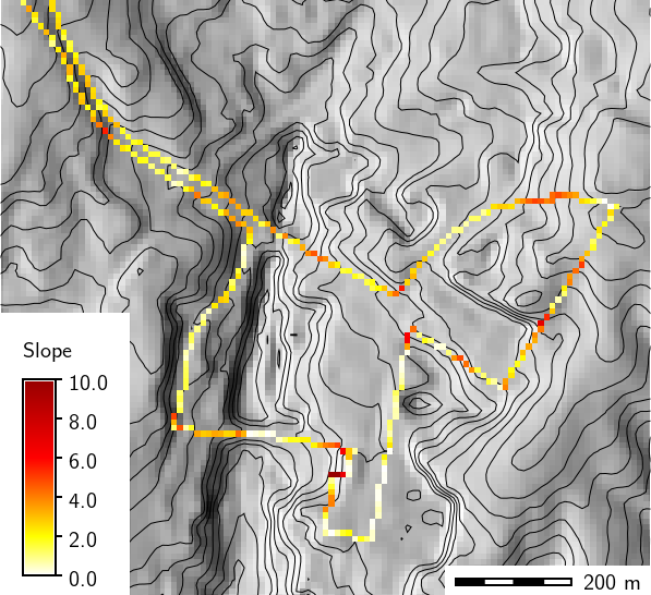
Slope in degrees along bus route
Convert a vector polygon map to raster including descriptive labels
In this example, the ZIP code vector map is rasterized (North Carolina sample dataset):
# rasterize ZIP codes at 50m raster resolution
g.region vector=zipcodes_wake res=50 -ap
# vector to raster conversion, with category labels
v.to.rast input=zipcodes_wake output=myzipcodes use=attr attribute_column="ZIPNUM" label_column="NAME"
Convert vector points to raster with raster cell binning
In this example, the number of schools per raster cell are counted (North Carolina sample dataset):
g.copy vector=schools_wake,myschools_wake

# set computation region for raster binning
g.region vector=myschools_wake res=5000 -p -a

# add new column for counting
v.db.addcolumn myschools_wake column="value integer"
v.db.update myschools_wake column=value value=1

# verify attributes
v.db.select myschools_wake column=cat,value
v.out.ascii input=myschools_wake output=- column=value

# export and import on the fly, use 4th column (value) as input
v.out.ascii input=myschools_wake output=- column=value | r.in.xyz input=- \
            z=4 output=schools_wake_aggreg method=sum

d.mon wx0
d.rast schools_wake_aggreg
d.vect schools_wake
d.grid 5000
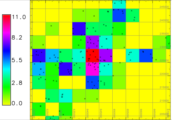
Number of schools per raster cell
SEE ALSO
AUTHORS
Original code: Michael Shapiro, U.S. Army Construction Engineering
Research Laboratory
GRASS 6.0 updates: Radim Blazek, ITC-irst, Trento, Italy
Stream directions: Jaro Hofierka and Helena Mitasova
GRASS 6.3 code cleanup and label support: Brad Douglas
SOURCE CODE
Available at: v.to.rast source code
(history)
Latest change: Friday May 09 14:33:40 2025 in commit b356c7e