v.to.rast3
Converts a vector map (only points) into a 3D raster map.
v.to.rast3 input=name [layer=string] output=name column=name [--overwrite] [--verbose] [--quiet] [--qq] [--ui]
Example:
v.to.rast3 input=name output=name column=name
grass.tools.Tools.v_to_rast3(input, layer="1", output, column, overwrite=None, verbose=None, quiet=None, superquiet=None)
Example:
tools = Tools()
tools.v_to_rast3(input="name", output="name", column="name")
This grass.tools API is experimental in version 8.5 and expected to be stable in version 8.6.
grass.script.run_command("v.to.rast3", input, layer="1", output, column, overwrite=None, verbose=None, quiet=None, superquiet=None)
Example:
gs.run_command("v.to.rast3", input="name", output="name", column="name")
Parameters
input=name [required]
Name of input vector map
Or data source for direct OGR access
layer=string
Layer number or name
Vector features can have category values in different layers. This number determines which layer to use. When used with direct OGR access this is the layer name.
Default: 1
output=name [required]
Name for output 3D raster map
column=name [required]
Name of attribute column (data type must be numeric)
--overwrite
Allow output files to overwrite existing files
--help
Print usage summary
--verbose
Verbose module output
--quiet
Quiet module output
--qq
Very quiet module output
--ui
Force launching GUI dialog
input : str, required
Name of input vector map
Or data source for direct OGR access
Used as: input, vector, name
layer : str, optional
Layer number or name
Vector features can have category values in different layers. This number determines which layer to use. When used with direct OGR access this is the layer name.
Used as: input, layer
Default: 1
output : str, required
Name for output 3D raster map
Used as: output, raster_3d, name
column : str, required
Name of attribute column (data type must be numeric)
Used as: input, dbcolumn, name
overwrite : bool, optional
Allow output files to overwrite existing files
Default: None
verbose : bool, optional
Verbose module output
Default: None
quiet : bool, optional
Quiet module output
Default: None
superquiet : bool, optional
Very quiet module output
Default: None
Returns:
result : grass.tools.support.ToolResult | None
If the tool produces text as standard output, a ToolResult object will be returned. Otherwise, None will be returned.
Raises:
grass.tools.ToolError: When the tool ended with an error.
input : str, required
Name of input vector map
Or data source for direct OGR access
Used as: input, vector, name
layer : str, optional
Layer number or name
Vector features can have category values in different layers. This number determines which layer to use. When used with direct OGR access this is the layer name.
Used as: input, layer
Default: 1
output : str, required
Name for output 3D raster map
Used as: output, raster_3d, name
column : str, required
Name of attribute column (data type must be numeric)
Used as: input, dbcolumn, name
overwrite : bool, optional
Allow output files to overwrite existing files
Default: None
verbose : bool, optional
Verbose module output
Default: None
quiet : bool, optional
Quiet module output
Default: None
superquiet : bool, optional
Very quiet module output
Default: None
DESCRIPTION
v.to.rast3 converts a GRASS 3D vector point map to a GRASS 3D raster map.
NOTES
When converting from a 3D vector point layer to a 3D raster map a vector point is converted into a single 3D raster cell (voxel) representing the location of the vector point. As 3D raster cell value the database attribute of the vector point is stored with floating point precision.
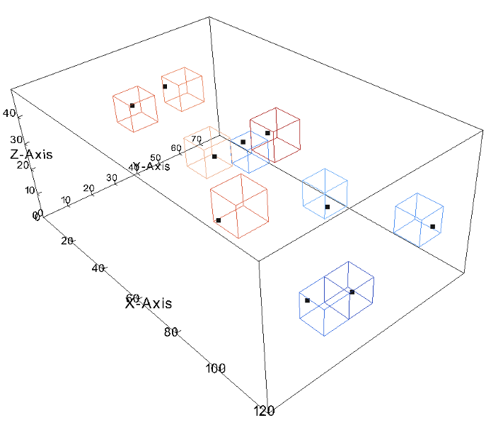
Fig: This screenshot shows the result of the v.to.rast3 test.
Visualized are the cube of the GRASS region, the vector points as black dots
and the voxel cells as wireframe model.
Only cells with non-null values are shown.
SEE ALSO
AUTHORS
Original s.to.rast3: Jaro Hofierka, Geomodel s.r.o.
Updated by Radim Blazek
SOURCE CODE
Available at: v.to.rast3 source code
(history)
Latest change: Tuesday Feb 25 14:08:58 2025 in commit 429a884