
NAME
r.li.padrange - Calculates range of patch area size on a raster map
KEYWORDS
raster, landscape structure analysis, patch index
SYNOPSIS
r.li.padrange
r.li.padrange help
r.li.padrange map=name conf=string output=name [--overwrite] [--verbose] [--quiet]
Flags:
- --overwrite
- Allow output files to overwrite existing files
- --verbose
- Verbose module output
- --quiet
- Quiet module output
Parameters:
- map=name
- Name of input raster map
- conf=string
- Configuration file
- output=name
- Name for output raster map
DESCRIPTION
r.li.padrange
(patch area distribution range) calculates
as:
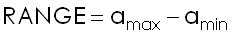
with:
- amax: max patch area size
- amin: min patch area size
EXAMPLES
To calculate range of patch area size, using
my_conf configuration file and saving results in
my_out file run:
r.li.padrange map=my_map conf=my_conf output=my_out
NOTES
Do not use absolute path names for output files. They are raster if
moving window disposition was selected, otherwise they are in
~/.r.li/output folder.
If input raster is not full of null values r.li.padrange returns a
value >=0 that is PADcv.
If input raster is full of null values r.li.padrange returns -1.
If you want to have null values instead run
r.null setnull=-1 map=my_map
REFERENCES
McGarigal, K., and B. J. Marks. 1995. FRAGSTATS: spatial pattern
analysis program for quantifying landscape structure. USDA For. Serv.
Gen. Tech. Rep. PNW-351.
SEE ALSO
r.li
AUTHORS
Serena Pallecchi student of Computer Science University of Pisa (Italy).
Commission from Faunalia Pontedera (PI), Italy (www.faunalia.it)
BUGS
Please send bugs reports to
pallecch@cli.di.unipi.it
Last changed: $Date: 2007-02-08 08:27:23 -0800 (Thu, 08 Feb 2007) $
Main index - raster index - Full index
© 2003-2008 GRASS Development Team