Note: This document is for an older version of GRASS GIS that is outdated. You should upgrade, and read the current manual page.

NAME
r.li.padsd - Calculates standard deviation of patch area a raster map
KEYWORDS
raster, landscape structure analysis, patch index
SYNOPSIS
r.li.padsd
r.li.padsd help
r.li.padsd map=name conf=name output=name [--overwrite] [--verbose] [--quiet]
Flags:
- --overwrite
- Allow output files to overwrite existing files
- --verbose
- Verbose module output
- --quiet
- Quiet module output
Parameters:
- map=name
- Name of input raster map
- conf=name
- Configuration file
- output=name
- Name for output raster map
DESCRIPTION
r.li.padsd calculates the standard deviation of patch
area sizes in hectares as:
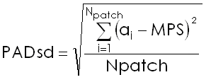
with:
- MPS: mean patch area size
- ai: area of patch i
- Npatch: number of patches
This index is calculated using a 4 neighbour algorithm, diagonal cells
are ignored when tracing a patch.
NOTES
Do not use absolute path names for the output map/file.
If the "moving window" method was selected in r.li.setup, then the
output will be a raster map, otherwise an ASCII file will be generated in
the $HOME/.r.li/output/ folder.
If input raster is not full of null values r.li.padsd returns a
value >=0 that is PADsd.
If the input raster map contains only NULL values then r.li.padsd returns -1.
If you want to change these -1 values to NULL, run subsequently on the resulting map:
r.null setnull=-1 map=my_map
EXAMPLES
To calculate patch area distribution standard deviation index on map my_map, using
my_conf configuration file (previously defined with
r.li.setup) and saving results in my_out, run:
r.li.padsd map=my_map conf=my_conf output=my_out
Forest map (Spearfish sample dataset) example:
g.region rast=landcover.30m -p
r.mapcalc "forests = if(landcover.30m >= 41 && landcover.30m <= 43,1,null())"
r.li.padsd map=forests conf=movwindow7 out=forests_padsd_mov7
r.univar forests_padsd_mov7
SEE ALSO
r.li - package overview
r.li.setup
REFERENCES
McGarigal, K., and B. J. Marks. 1995. FRAGSTATS: spatial pattern
analysis program for quantifying landscape structure. USDA For. Serv.
Gen. Tech. Rep. PNW-351. (PDF)
AUTHORS
Serena Pallecchi student of Computer Science University of Pisa (Italy).
Commission from Faunalia Pontedera (PI), Italy (www.faunalia.it)
Last changed: $Date: 2014-02-18 16:24:09 -0800 (Tue, 18 Feb 2014) $
Main index - raster index - Full index
© 2003-2014 GRASS Development Team