Note: This document is for an older version of GRASS GIS that will be discontinued soon. You should upgrade, and read the current manual page.
Note: This addon document is for an older version of GRASS GIS that will be discontinued soon. You should upgrade your GRASS GIS installation, and read the current addon manual page.
NAME
r.lake.series - Fills lake at given point(s) to given levels.KEYWORDS
raster, hydrology, hazard, floodSYNOPSIS
Flags:
- -n
- Use negative depth values for lake raster map
- This flag is passed to r.lake module.
- -c
- Use map number instead of the water level in map name (currently ignored)
- This names are always in the right alphabetical order and are also valid vector map names.
- --overwrite
- Allow output files to overwrite existing files
- --help
- Print usage summary
- --verbose
- Verbose module output
- --quiet
- Quiet module output
- --ui
- Force launching GUI dialog
Parameters:
- elevation=name [required]
- Name of input elevation raster map
- output=name [required]
- Name of the output space time raster dataset
- The name of the dataset is used as a base name for created output maps. Map names will consist of a base name, underscore and water level value or number depending on -c flag.
- start_water_level=float [required]
- Start water level
- Units should be meters?
- end_water_level=float [required]
- Final (maximal) water level
- Units should be meters?
- water_level_step=float [required]
- Water level step
- Units should be meters?
- coordinates=east,north
- Seed point coordinates
- Either this coordinates pair or a seed map name have to be specified.
- seed_raster=name
- Name of input raster map with given starting point(s) (at least 1 cell > 0)
- Either this parameter or a coordinates pair have to be specified.
- time_step=integer
- Time increment
- Time increment between two states (maps) used to register output maps in space-time raster dataset. Used together with time_units parameter.
- Options: 0-
- Default: 30
- time_unit=string
- Time units
- Time units used to register output maps in space-time raster dataset. Used together with time_step parameter.
- Options: years, months, days, hours, minutes, seconds
- Default: minutes
- nproc=integer
- Number of processes to run in parallel (currently ignored)
- Options: 1-
- Default: 1
Table of contents
DESCRIPTION
r.lake.series fills a lake or any area from a given start point or areas specified by raster map (seed_raster option). The module generates one map containing filled areas for each water level specified by water level options (start_water_level, end_water_level, water_level_step). This module uses r.lake module to generate individual maps for the map series. See r.lake manual for further discussion. Note that water level is absolute height, so it should be in same range as you digital elevation model. On the other hand, water depth in output maps is relative to the water level.This module outputs:
- a space-time raster dataset containing a map series
- a map series containing maps of areas with water for each water level
EXAMPLE
The following example presents a bigger flooding in rural area of North Carolina sample dataset and included also visualization examples.
# using unix-like shell syntax

# set computational region
g.region raster=elev_lid792_1m
# prepare input data
v.to.rast -d input=streams output=rural_streams use=val val=1

# compute a flooding scenario
r.lake.series elevation=elev_lid792_1m seed=rural_streams \
              start_wl=104.0 end_wl=115.0 wl_step=0.2 output=flooding

# visualize the flooding space-time raster dataset
g.gui.animation strds=flooding

# alternatively explore maps from dataset
# prepare shaded relief map
r.relief input=elev_lid792_1m output=elev_lid792_1m_shade
# set color table for streams
r.colors map=rural_streams rules=- <<EOF
1 blue
EOF

# open d.mon or map display
d.mon wx1

# show base maps
d.rast elev_lid792_1m_shade
d.rast rural_streams

# show particular flooding maps
d.rast flooding_105.0
d.rast flooding_108.0
d.rast flooding_114.0
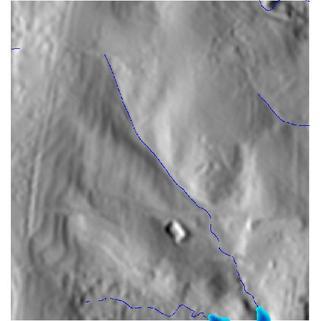
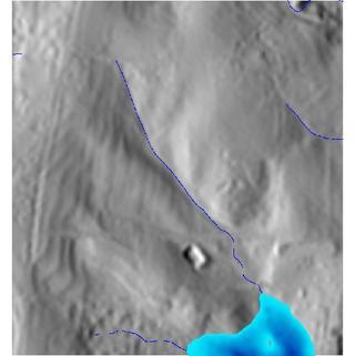
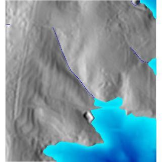
Figure: A bigger flooding in rural area of North Carolina sample dataset with water level at 105, 108 and 114 meters (water depth differs in different areas).
SEE ALSO
r.lakeAUTHORS
Vaclav Petras, NCSU OSGeoREL,Maris Nartiss (author of r.lake)
SOURCE CODE
Available at: r.lake.series source code (history)
Latest change: Monday Jun 28 07:54:09 2021 in commit: 1cfc0af029a35a5d6c7dae5ca7204d0eb85dbc55
Note: This document is for an older version of GRASS GIS that will be discontinued soon. You should upgrade, and read the current manual page.
Note: This addon document is for an older version of GRASS GIS that will be discontinued soon. You should upgrade your GRASS GIS installation, and read the current addon manual page.
Main index | Raster index | Topics index | Keywords index | Graphical index | Full index
© 2003-2023 GRASS Development Team, GRASS GIS 7.8.9dev Reference Manual