Note: This document is for an older version of GRASS GIS that will be discontinued soon. You should upgrade, and read the current manual page.
Note: This addon document is for an older version of GRASS GIS that will be discontinued soon. You should upgrade your GRASS GIS installation, and read the current addon manual page.
NAME
v.in.survey - Creates multiple vector layers from just one textfileKEYWORDS
vector, import, ASCII, multipleSYNOPSIS
Flags:
- -z
- Create 3D vector map
- -e
- Create a new empty vector map and exit. Nothing is read from input.
- -n
- Do not expect a header when reading in standard format
- -t
- Do not create table in points mode
- -r
- Only import points falling within current region (points mode)
- -x
- Convert to DXF
- --help
- Print usage summary
- --verbose
- Verbose module output
- --quiet
- Quiet module output
- --ui
- Force launching GUI dialog
Parameters:
- input=name [required]
- Name of input file to be imported
- separator=character
- Field separator
- Special characters: pipe, comma, space, tab, newline
- Default: pipe
- pt_rules=string[,string,...]
- Point(s): hosp.pt.01..., forest.tree.01 -> 'pt,tree'
- ln_rules=string[,string,...]
- Line(s): road.ln.01..., Danube.river.01 -> 'ln,river'
- poly_rules=string[,string,...]
- Polygon(s): hosp.area.01,..., forest.area.01 -> 'area'
- skip=integer
- Number of lines to skip at top of input file (points mode)
- Default: 0
- columns=string
- Column definition in SQL style (points mode))
- E.g.: 'x double precision, y double precision, cat int, name varchar(10)'
- easting=integer
- Number of column used as easting coordinate (points mode)
- First column is 1
- Default: 2
- northing=integer
- Number of column used as northing coordinate (points mode)
- First column is 1
- Default: 3
- elevation=integer
- Number of column used as elevation (points mode)
- First column is 1. If 0, z coordinate is not used
- Default: 0
- outdir=name
- Name of directory to store separated files for each layer
- merge_lyrs=string[,string,...]
- Pattern(s) for layers to be merged
- dxf_file=string
- Name of the DXF file
- draw_unit=string
- Drawing units
- Options: metric, imperial
- Default: metric
- textsize=string
- Text height of the labels in DXF file
- Default: 0.
Table of contents
DESCRIPTION
v.in.survey imports points from ASCII file into specific vector layers by point names. The script joins several modules to perform following steps:- The data is sorted according to point names to keep points from separated layers together.
- The script scans input file and creates separate files for each layer. Layers are distinguished by
point names that provide information on layer name, vector type and point identifier. More detailed information about
how to draft point names in your dataset (during data acquisition or in post-processing) is provided in Notes
section.
- Line and polygon data are converted to standard format (input data should respect topological rules to get
geometrically correct layers).
- Then, new vector layer is created using v.in.ascii. Points are stored in point layer; lines and polygons in
line layer at this moment. Lines that store polygon data are converted to new polygon layer using v.centroid.
- Attribute table is maintained for line and polygon layers (points are imported in point format with the attributes
as well).
- in case of line layers, categories are added at first using v.category,
- attribute table is created using v.db.addtable,
- column that stores layer name is updated using v.db.update.
- There is an option to merge the features by v.patch using various patterns to detect desired layers.
For more details, see Notes.
- Finally, v.clean is performed to clean the topology if any layers have been merged.
- If desired, conversion to DXF file is performed as well.
NOTES
Input data
Several recommendations how to format the data:- only input data in point format is accepted. The file should contain just point identifier (see next item) and
coordinates in two- or three-dimensional space.
It does not depend on the coordinate order in the input file. The user can set up number of column for each coordinate (as in v.in.ascii).
		Point_name		easting	northing	[elevation]
		name.code.number	x	y		[z]
- Point name provides information that is substantial for new layer creation - name and desired type of vector. Required
format of the point name looks like this:
Items are separated by dots. To get correct results, please remove or replace all redundant dots in the input data.
layer_name.code.number
name
any short, descriptive name as you wish your layer to be named. Please do not use spaces or dots. code
information about vector type of the new layer (point, line, polygon). You may define your own codes that refer directly to the geometry (e.g. point, line, poly etc. including various abbreviations). Or you may specify that e.g. tree, bush etc. are codes for point features, river, profile etc. refer to line segments and lake and house represent new polygon layers. number
simple identifier of the point in the layer (preferably plain numbering) - if using a header or columns' names, refer this in skip parameter
- if necessary to merge any layers, please give them a name with specific prefix, which should be used as
merging rule as well. Merging rule that is based on suffix or another part of the layer name is not recognized.
- if the module crashes suddenly during large dataset processing, it might be caused by incomplete data writing to the layer input file. Please divide input data into several smaller files (probably depends on your computer performance).
Conversion to DXF
If you wish to convert the data to DXF, please use -x flag. Then, it is necessary to set up:- the name of DXF file. The file will be written into the output directory.
- drawing units. Default value: metric. Another option: imperial.
- height of the text. Default value: 0.0 (the height will be derived as a fraction (0.003) of longer side of a rectangular mapset region)
EXAMPLES
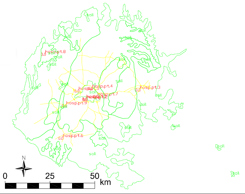
This example is based on the sample dataset of North Carolina (nc_spm_08_grass7). Point vector layer hospitals, line vector layer railroads and polygon vector layer soil_general have been exported to the text files, vertices have been renamed and the files have been merged. This final input was used as test data for the script.v.in.survey input=test_data.dat separator=tab skip=1 easting=2 northing=3 pt_rules=pt ln_rules=ln poly_rules=poly outdir=NC_test
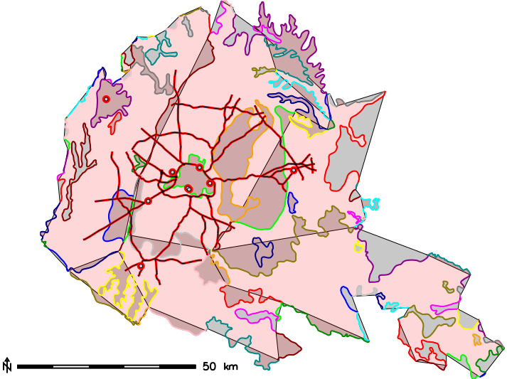
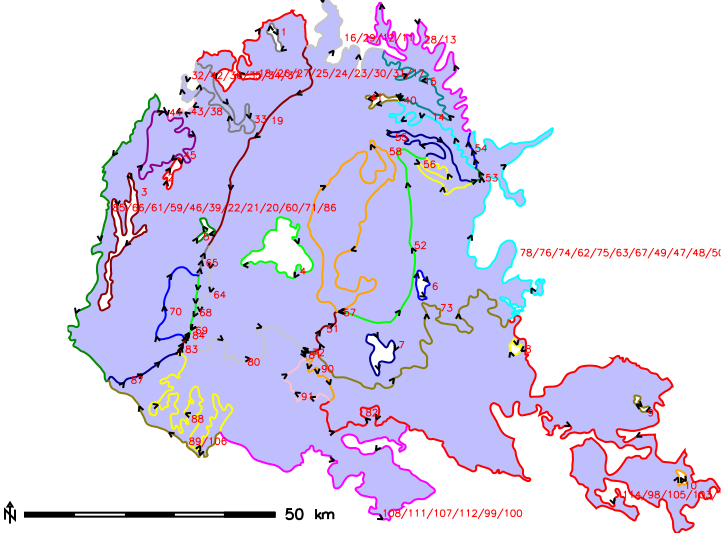
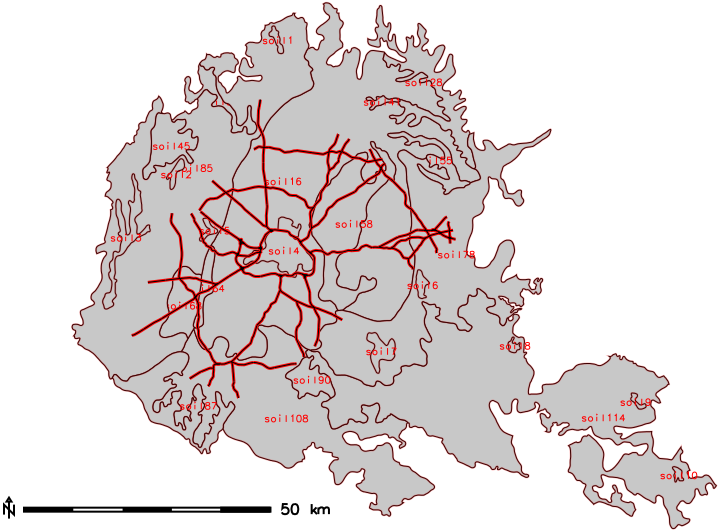
| Fig. 1: Imported features with broken areas | Fig. 2: Lines with the directions | Fig. 3: Imported features with correct areas |
|
|
|
To fix broken areas, original lines have been merged using v.edit according to their categories. Then points have been exported again and they were copied to enclose each area - respecting lines and the directions as might be seen in Fig. 2. In Fig. 3, there is shown that areas fit well too after editing input file.
If it is necessary also to merge some of the layers, then merging rules can be set up:
	v.in.survey input=test_data_small_corrected_soils.dat separator=tab easting=2 northing=3 pt_rules=pt ln_rules=ln poly_rules=poly \
	outdir=NC_test_small_merge merge_lyrs=road,soil
|
Fig. 1: DXF drawing together with the labels (north arrow and scale have been added later) |
|
The colours in DXF drawing have been set up automatically. In this case, labels of roads and elevation labels of soil types have been switched of because of too large amount of the data. Examples of more detailed exports can be seen in (Stopkova, 2016).
WARNINGS
WARNING: There are no layers to merge into <item>.Any imported layer does not match given item referring how to merge layers in script settings.
ERROR MESSAGES
Input data:
ERROR: Too many columns. Use input data in format 'name east north [elev]', please.Current version supports only import of 2D or 3D geometry and point name. Edit input file and run script again.
ERROR: Please rename point in line i according to the script request in format
'lyr_name.vect_type_code.number'.
Point name is expected to provide information in particular format. Edit point name in ith line of the
input file and run script again.
ERROR: Please do not use SQL forbidden characters in your input data. Remove all 'char' from the file.
Any special characters are not allowed in the data. Please use just dots to separate parts of point names. If
necessary, make the names more clear using underscores.
ERROR: Not enough points to make line layer <layer>.
ERROR: Not enough points to make polygon layer <layer>.
These errors may refer to:
- a typographical mistake in particular point's name. Edit point's name in the input file and run script again.
- mixed layers. See (Stopkova, 2016) for more details. Edit point's name in the input file and run script again.
- broken geometry (just one point referring to a line or less than three points referring to a polygon). Please remove these points or edit their vector type (middle part of point name) to refer to a point.
Script settings:
ERROR: Wrong separator type.The separator does not fit the data file. Please set up another type: pipe, comma, space, tab, newline. Default: pipe
ERROR: Vector layer layer is not point, neither line, nor boundary. Please check your input data and rules that
you have typed in.
Vector type information (middle part of the point name) does not match to any of geometry codes that you have
entered. Please compare input settings with point names in the data file, complete input settings (or edit input data)
and run the script again.
ERROR: Please redefine merging option <char>. Different vector types match this rule.
Merging different vector types is not allowed. This might be matter of comparing layer names with too free rules:
| river | river -> river_stream | |
| river_stream_Danube | river_area_Danube | |
| river_stream_Vah | river_stream_Vah | |
| river_stream_Hron | river_stream_Hron |
In the left column, there are summarized line objects that should be merged to one single layers called river. This merge is possible, as all the features are represented by line. In the right column, there are summarized rivers as well. But they cannot be merged, because the Danube river is represented by polygon and the rest of the features are lines. It would be better to use merging criteria river_stream to separate just line object to be merged.
Files:
ERROR: File filename does not exist.Missing input file.
Output layers:
ERROR: Vector layer <layer> exists. Please remove the layer or rename the input points.There is a layer with identical name in the mapset. Overwrite it, rename it or rename the layer in the input file (edit points names). However, this error usually happens if points that belong to several layers are mixed in the file as well. How to prevent this, examples in (Stopkova, 2016) can demonstrate.
Empty layer (not reported in command output): if the layer exists but is empty, please check the input points. This might happened because of wrong point order (especially if the point order has been edited).
DXF conversion:
ERROR: Please set up the drawing units to 'metric' or to 'imperial'.Anything else cannot be accepted (in accordance to DXF settings). Default value: metric.
SEE ALSO
v.in.asciiv.centroids
g.remove
v.db.addtable
v.db.update
v.patch
v.clean
v.out.dxf
Stopkova, E. (in print). Open-source tool for automatic import of coded surveying data to multiple vector layers in GIS environment. In Geoinformatics FCE CTU. Vol. 15, No. 2 (2016). Prague: Czech Technical University, Faculty of Civil Engineering. ISSN 1802-2669. DOI.
AUTHOR
Eva Stopkovafunctions for DXF conversion are taken from (or based on) the module v.out.dxf (Charles Ehlschlaeger and Radim Blazek)
SOURCE CODE
Available at: v.in.survey source code (history)
Latest change: Monday Jun 28 07:54:09 2021 in commit: 1cfc0af029a35a5d6c7dae5ca7204d0eb85dbc55
Note: This document is for an older version of GRASS GIS that will be discontinued soon. You should upgrade, and read the current manual page.
Note: This addon document is for an older version of GRASS GIS that will be discontinued soon. You should upgrade your GRASS GIS installation, and read the current addon manual page.
Main index | Vector index | Topics index | Keywords index | Graphical index | Full index
© 2003-2023 GRASS Development Team, GRASS GIS 7.8.9dev Reference Manual