NAME
r.droka - Calculates run-out distance of a falling rock massKEYWORDS
rock mass, rockfallSYNOPSIS
Flags:
- --overwrite
- Allow output files to overwrite existing files
- --help
- Print usage summary
- --verbose
- Verbose module output
- --quiet
- Quiet module output
- --ui
- Force launching GUI dialog
Parameters:
- dem=string [required]
- Digital Elevation Model
- start=string [required]
- Name of starting points map
- ang=float [required]
- Shadow angle
- red=float [required]
- Reduction value
- Options: 0-1
- Default: 0.9
- m=float [required]
- Value of rock mass (Kg)
- num=integer [required]
- Number of boulders (>=1)
- prefix=name [required]
- Prefix for output raster maps
- n=integer
- Buffer distance (meters)
Table of contents
DESCRIPTION
The intersection between the topographic profile and the line starting from the point of detachment with a certain angle to the horizontal line defines the point of maximum propagation (Evans and Hungr, 1993; Jaboyedoff and Labiouse, 2003). The angle of inclination and the line of propagation are defined as zenith angle and shadow zone. This script defines rockfall zones from a digital elevation model (DEM) and vector layer containing starting point or points.
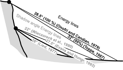
Energy line used for the cone method from the top or the bottom of a cliff (shadow angle), according to various authors (Image from Jaboyedoff and Labiouse, 2003)
INPUT
Digital Elevation Model = name
- Name of elevation raster map
Starting points = name
- Name of vector map containing rockfall source area. It can be one point or more.
Shadow angle = integer
- Angle of inclination that defines the propagation zone. It's calculated from an horizontal plane starting from source point: highest values determine a lowest propagation.
Reduction value = double
- Reduction moltiplicator for velocity. Default value is 0.9
Number of boulders = integer
- For each starting point can be generated other random points used in the computations. By default points are located in a radius from the starting point equal to: (cell size * number of boulders)/2. Insert 1 for use only the original starting point or points. Note that a high number of boulders can make excessively long the calculation times.
Rock mass = double
- Value of rock mass (Kg)
Output prefix = string
- Name of prefix used for output raster maps
Buffer distance = integer
- This value define the radius for randomly generatin boulders starting from starting point. It's in the option dialog window.
OUTPUT
r.droka generates 5 raster maps and a vector map. The names of all output maps start with the prefix defined by the parameter prefix followed by name of map
- prefix_propagation: raster map rapresenting the area of propagation. If are used multiple source points, each pixel show the percentage of passage (%)
- prefix_vel_max: maximum rock-fall translational velocities (m/sec)
- prefix_vel_med: medium rock-fall translational velocities (m/sec)
- prefix_vel_max: medium kinetic energy (kJ)
- prefix_en_max: maximum kinetic energy (kJ)
- prefix_starting: vector map of starting points
REFERENCES
FILIPELLO A., GIULIANI A., MANDRONE G. (2010) - Rock Slopes Failure Susceptibility Analysis: From Remote Sensing Measurements to Geographic Information System Raster Modules. American Journal of Environmental Sciences 6 (6): 489-494, 2010 ISSN 1553-345X 2010 Science Publications.
JABOYEDOFF M., LABIOUSE V. (2003) - Preliminary assessment of rockfall hazard based on GIS Data. Proceeding of the 10th ISRM Congress, South African Inst. Min. Met., Johannesburg, pp: 575-578
EVANS, S.G., HUNGR O. (1993). The assessment of rock fall hazard at the base of the talus slope. Can. Geotech. J., 30: 620-636. DOI: 10.1139/t93-054
SEE ALSO
AUTHORS
Andrea Filipello, University of Turin, Italy
Daniele Strigaro, University of Milan, Italy
SOURCE CODE
Available at: r.droka source code (history)
Main index | Raster index | Topics index | Keywords index | Graphical index | Full index
© 2003-2018 GRASS Development Team, GRASS GIS 7.4.1svn Reference Manual