NAME
r.sentinel.import - Imports Sentinel data downloaded from Copernicus Open Access Hub using r.sentinel.download.KEYWORDS
raster, imagery, sentinel, importSYNOPSIS
Flags:
- -o
- Reproject raster data using r.import if needed
- -l
- Link raster data instead of importing
- -c
- Import cloud masks as vector maps
- --help
- Print usage summary
- --verbose
- Verbose module output
- --quiet
- Quiet module output
- --ui
- Force launching GUI dialog
Parameters:
- input=name [required]
- Name for input directory where downloaded Sentinel data lives
- pattern=string
- File name pattern to import
By default r.sentinel.import imports all Sentinel bands found in input directory by r.import. Note that in the case that spatial reference system of input data differs from GRASS location, the input data are reprojected.
Optionally input data can be linked by r.external when -l is given. Note that linking data requires that input data and GRASS location have the same spatial reference system.
Number of imported Sentinel bands can be optionally reduced by pattern option.
NOTES
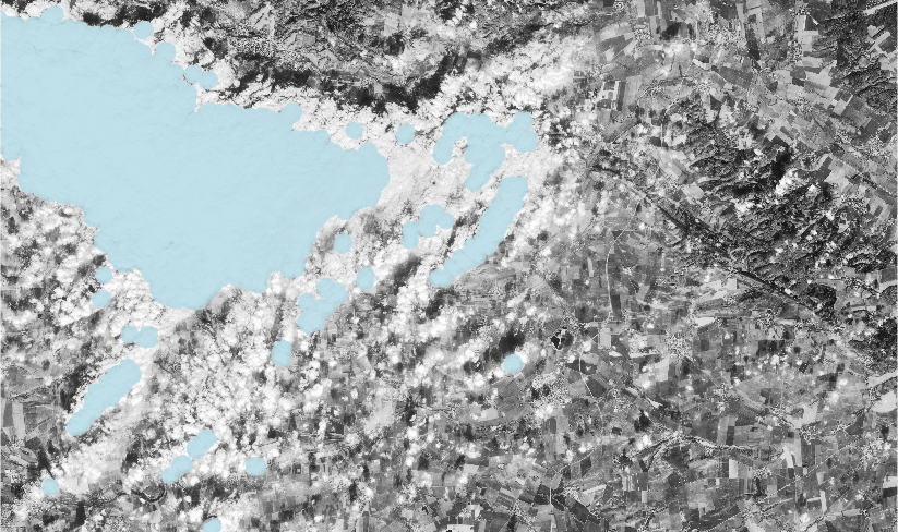
If -c flag is given, than also cloud mask file is imported as vector map if available. Name of created vector map is determined from input Sentinel product.
EXAMPLES
Import all Sentinel bands found in data directory.r.sentinel.import input=data
r.sentinel.import input=data pattern='B0[4|8]'
r.sentinel.import -l -c input=data

Fig: Band 4 with imported cloud mask
SEE ALSO
r.sentinel.download, r.import, r.external, v.importAUTHOR
Martin Landa, GeoForAll Lab, CTU in Prague, Czech Republic with support of OpenGeoLabs companySOURCE CODE
Available at: r.sentinel.import source code (history)
Main index | Raster index | Topics index | Keywords index | Graphical index | Full index
© 2003-2018 GRASS Development Team, GRASS GIS 7.4.1svn Reference Manual