Note: A new GRASS GIS stable version has been released: GRASS GIS 7.8, available here.
Updated manual page: here
NAME
i.tasscap - Performs Tasseled Cap (Kauth Thomas) transformation.KEYWORDS
imagery, transformation, Landsat, MODIS, Tasseled Cap transformationSYNOPSIS
i.tasscap
i.tasscap --helpi.tasscap input=name[,name,...] output=basename sensor=string [--overwrite] [--help] [--verbose] [--quiet] [--ui]
Flags:
- --overwrite
- Allow output files to overwrite existing files
- --help
- Print usage summary
- --verbose
- Verbose module output
- --quiet
- Quiet module output
- --ui
- Force launching GUI dialog
Parameters:
- input=name[,name,...] [required]
- For Landsat4-7: bands 1, 2, 3, 4, 5, 7; for Landsat8: bands 2, 3, 4, 5, 6, 7; for MODIS: bands 1, 2, 3, 4, 5, 6, 7
- output=basename [required]
- Name for output basename raster map(s)
- Name for output basename raster map(s)
- sensor=string [required]
- Satellite sensor
- Options: landsat4_tm, landsat5_tm, landsat7_etm, landsat8_oli, modis
- landsat4_tm: Use transformation rules for Landsat 4 TM
- landsat5_tm: Use transformation rules for Landsat 5 TM
- landsat7_etm: Use transformation rules for Landsat 7 ETM
- landsat8_oli: Use transformation rules for Landsat 8 OLI
- modis: Use transformation rules for MODIS
Table of contents
DESCRIPTION
i.tasscap calculates Tasseled Cap (Kauth Thomas, TC) transformation for Landsat TM data (TM4, TM5, ETM7) and MODIS data. The tasseled cap transformation is effectively a compression method to reduce multiple spectral data into a few bands. The method was originally developed for understanding important phenomena of crop development in spectral space (Kauth and Thomas, 1976).Tasseled cap coefficients for Landsat 7 ETM+ are at-satellite reflectance values (C. Huang et al., 2001), the conversion can be achieved with i.landsat.toar.
The following tasseled cap components are generated:
- tasscap.1: corresponds to brightness,
- tasscap.2: corresponds to greenness,
- tasscap.3: corresponds to wetness,
- tasscap.4: corresponds to atmospheric haze (only selected sensors: Landsat 5,7,8).
EXAMPLE
Calculation of TC maps from North Carolina Landsat 7 ETM scene:# See manual page of i.landsat.toar for preprocessing g.region raster=lsat7_2002_toar.1 -p i.tasscap sensor=landsat7_etm \ input=lsat7_2002_toar.1,lsat7_2002_toar.2,lsat7_2002_toar.3,lsat7_2002_toar.4,lsat7_2002_toar.5,lsat7_2002_toar.7 \ output=lsat7_2002_tasscap
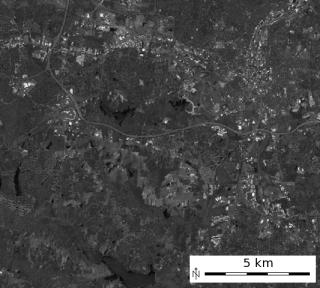
'Brightness' Tasseled Cap component 1 |
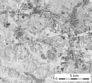
'Greenness' Tasseled Cap component 2 |
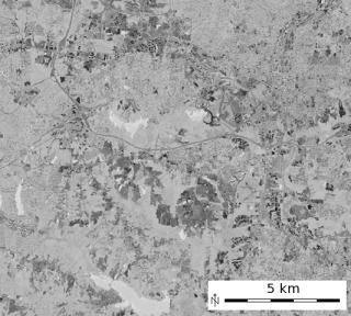
'Wetness' Tasseled Cap component 3 |
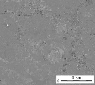
'Atmospheric haze' Tasseled Cap component 4 |
REFERENCES
- LANDSAT-4/LANDSAT-5: TC-factor changed to CRIST et al. 1986, Proc. IGARSS 1986, p.1467
- Crist, E. P., 1985, A TM tasseled cap equivalent transformation for reflectance factor data, Remote Sensing of Environment, 17: 301-306.
- LANDSAT-7: TASSCAP factors cited from:
DERIVATION OF A TASSELED CAP TRANSFORMATION BASED ON LANDSAT 7 AT-SATELLITE REFLECTANCE.
Chengquan Huang, Bruce Wylie, Limin Yang, Collin Homer and Gregory Zylstra Raytheon ITSS,
USGS EROS Data Center Sioux Falls, SD 57198, USA
http://landcover.usgs.gov/pdf/tasseled.pdf
This is published as well in INT. J. OF RS, 2002, VOL 23, NO. 8, 1741-1748. - MODIS Tasselled Cap coefficients - Ref: Lobser & Cohen (2007). MODIS tasselled cap: land cover characteristics expressed through transformed MODIS data. International Journal of Remote Sensing, Volume 28(22), Table 3
SEE ALSO
i.albedo, i.atcorr, i.landsat.toar, i.viAUTHORS
Dr. Agustin Lobo, original script, 1997Markus Neteler, ITC-irst, 2001
Converted to Python by Glynn Clements
Last changed: $Date$
SOURCE CODE
Available at: i.tasscap source code (history)
Note: A new GRASS GIS stable version has been released: GRASS GIS 7.8, available here.
Updated manual page: here
Main index | Imagery index | Topics index | Keywords index | Graphical index | Full index
© 2003-2020 GRASS Development Team, GRASS GIS 7.6.2dev Reference Manual