Note: This document is for an older version of GRASS GIS that has been discontinued. You should upgrade, and read the current manual page.
NAME
g.gui.datacatalog - Tool for browsing, modifying and managing GRASS maps.KEYWORDS
general, GUI, map managementSYNOPSIS
g.gui.datacatalog
g.gui.datacatalog --helpg.gui.datacatalog [--help] [--verbose] [--quiet] [--ui]
Flags:
- --help
- Print usage summary
- --verbose
- Verbose module output
- --quiet
- Quiet module output
- --ui
- Force launching GUI dialog
Table of contents
DESCRIPTION
The Data Catalog is a wxGUI component for browsing, modifying and managing GRASS maps.Data Catalog allows you to:
- browse GRASS locations and mapsets in the current GIS directory
- browse GRASS 2D/3D raster and vector maps
- rename, copy, move and delete GRASS maps including reprojection between different locations
- drag and drop maps for copying and moving
- searching and fitering maps using regular expressions
- display map in current location
- show metadata of maps
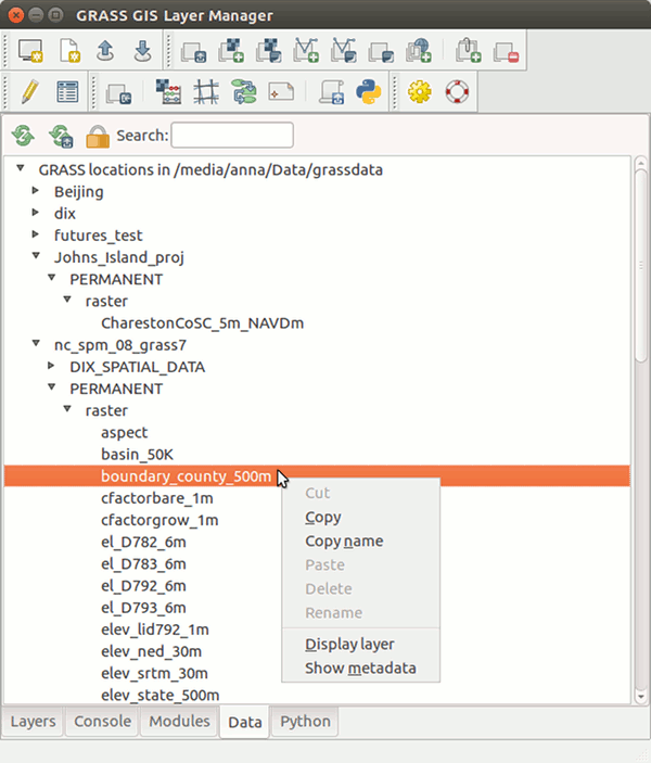
Figure: Data Catalog integrated in wxGUI.
NOTES
Some operations (copying, renaming, deleting) are by default enabled only within the current mapset. To allow changing data outside of your current mapset, you need to press Unlock button in Data Catalog toolbar.WARNING
When renaming, copying or deleting maps outside of Data Catalog, you need to reload the current mapset or entire database, because it is currently not synchronised.SEE ALSO
wxGUIwxGUI components
g.copy, g.rename, g.remove, g.list
AUTHOR
Anna Petrasova, NCSU GeoForAll LaboratoryTereza Fiedlerova, OSGeoREL, Czech Technical University in Prague, Czech Republic
SOURCE CODE
Available at: wxGUI Data Catalog source code (history)
Latest change: Saturday Jul 16 18:18:43 2022 in commit: effc544b795cef89a0c38628eee513eca82c266e
Main index | GUI index | Topics index | Keywords index | Graphical index | Full index
© 2003-2023 GRASS Development Team, GRASS GIS 7.8.9dev Reference Manual