Note: This document is for an older version of GRASS GIS that has been discontinued. You should upgrade, and read the current manual page.
NAME
g.gui.photo2image - Corrects scanning distortions of a paper photo.KEYWORDS
imagery, GUI, aerial, photo, georectification, geometry, GCPSYNOPSIS
Flags:
- --help
- Print usage summary
- --verbose
- Verbose module output
- --quiet
- Quiet module output
- --ui
- Force launching GUI dialog
Parameters:
- group=name [required]
- Name of input imagery group
- raster=name [required]
- Name of input raster map
- camera=string [required]
- The name of the camera (generated in i.ortho.camera)
- The name of the camera (generated in i.ortho.camera)
- order=string [required]
- The rectification order (no of Fiducial=4 -> order=1, no of Fiducial=8 -> order=2)
- The rectification order (no of Fiducial=4 -> order=1, no of Fiducial=8 -> order=2)
- Default: 1
- extension=string [required]
- The name of the output files extension (used in i.rectify)
- The name of the output files extension (used in i.rectify)
- Default: _ip2i_out
Table of contents
DESCRIPTION
This module is based on g.gui.gcp, the GCP manager of GRASS GIS. It is part of i.ortho.photo suite.The aim of this module is to give absolute location values to the fiducial points present (in number of 4 or 8) in a scanned aerial photo.
This is necessary as (manual) scanning introduces distortions, rotations and also may not be limited to scan the boundary of the photo itself. It is thus necessary to give to each fiducial the exact coordinates in mm as given by the aerial photographic instrument design, which is unique per camera.
This module requires you to have made a group with your aerial photo (i.group), a camera description file (i.ortho.target) and use them to launch the module. Additional requirements are the order of rectification (1 if no of Fiducials is 4, 2 if no of Fiducials is 8) and an extension file (if not given, defaults to \$filename_ip2i_out)
An example for Location imagery60:
g.gui.photo2image group=aerial@PERMANENT raster=gs13.1@PERMANENT camera=gscamera order=2 extension=try --o
Screenshot of g.gui.photo2image
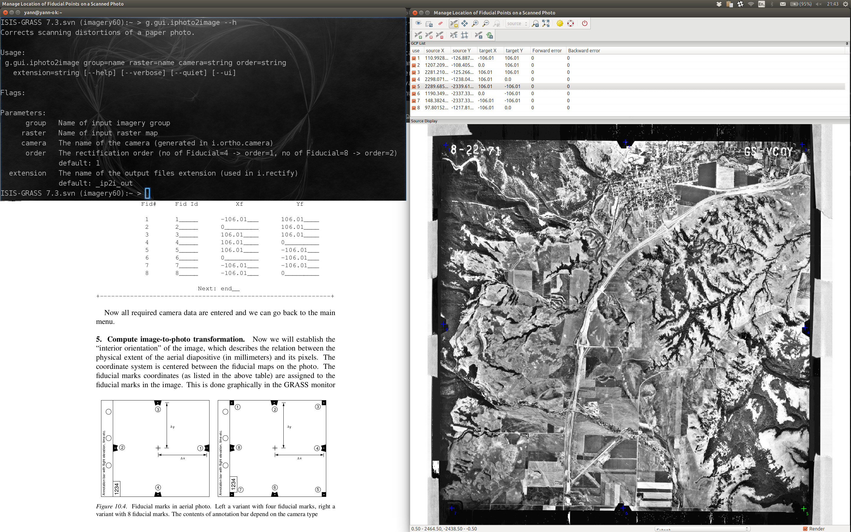
Figure: Screenshot of g.gui.photo2image
For a detailed operation manual please read
wxGUIwxGUI components
See also video tutorials on GRASS Wiki.
SEE ALSO
i.ortho.photo, i.group, i.ortho.camera, i.ortho.target, i.rectify, m.transform, v.rectifyAUTHORS
Markus MetzBased on the Georectifier (GRASS 6.4.0) by Michael Barton
Martin Landa, Czech Technical University in Prague, Czech Republic
SOURCE CODE
Available at: wxGUI GCP Manager for photo to image registration source code (history)
Latest change: Saturday Jul 16 18:18:43 2022 in commit: effc544b795cef89a0c38628eee513eca82c266e
Main index | GUI index | Topics index | Keywords index | Graphical index | Full index
© 2003-2023 GRASS Development Team, GRASS GIS 7.8.9dev Reference Manual