Note: This document is for an older version of GRASS GIS that has been discontinued. You should upgrade, and read the current manual page.
NAME
g.mapsets - Modifies/prints the user's current mapset search path.Affects the user's access to data existing under the other mapsets in the current location.
KEYWORDS
general, settings, search pathSYNOPSIS
Flags:
- -l
- List all available mapsets in alphabetical order
- -p
- Print mapsets in current search path
- -s
- Launch mapset selection GUI dialog
- --help
- Print usage summary
- --verbose
- Verbose module output
- --quiet
- Quiet module output
- --ui
- Force launching GUI dialog
Parameters:
- mapset=name[,name,...] [required]
- Name of mapset (default: current search path)
- Name(s) of existing mapset(s) to add/remove or set
- operation=string [required]
- Operation to be performed
- Options: set, add, remove
- Default: add
- separator=character
- Field separator for printing (-l and -p flags)
- Special characters: pipe, comma, space, tab, newline
- Default: space
Table of contents
DESCRIPTION
For basic information about GRASS mapset, location and data base refer to GRASS Quickstart.A mapset holds a distinct set of data layers, each relevant to the same (or a subset of the same) geographic region, and each drawn in the same map coordinate system. At the outset of every GRASS session, the user identifies a GRASS data base, location, and mapset that are to be the user's current data base, current location, and current mapset for the duration of the session; any maps created by the user during the session will be stored under the current mapset set at the session's outset (see g.mapset [without an "s"] and g.gisenv for changing the mapset with a session).
The user can add, modify, and delete data layers that exist under their current mapset. Although the user can also access (i.e., use) data that are stored under other mapsets in the same GRASS location using the mapname@mapsetname notation or mapset search path, the user can only make permanent changes (create or modify data) located in the current mapset. The user's mapset search path lists the order in which other mapsets in the same GRASS location can be searched and their data accessed by the user. The user can modify the listing and order in which these mapsets are accessed by modifying the mapset search path; this can be done using the g.mapsets command. This program allows the user to use other's relevant map data without altering the original data layer, and without taking up disk space with a copy of the original map. The mapname@mapsetname notation may be used irrespective of the mapset search path, i.e., any map found in another mapset with sufficient g.access privileges may be called in such a manner.
g.mapsets shows the user available mapsets under the current GRASS location, lists mapsets to which the user currently has access, and lists the order in which accessible mapsets will be accessed by GRASS programs searching for data files. The user is then given the opportunity to add or delete mapset names from the search path, or modify the order in which mapsets will be accessed.
When the user specifies the name of a data base element file (e.g., a particular vector map, raster map, imagery group file, etc.) to a GRASS program, the program searches for the named file under each of the mapsets listed in the user's mapset search path in the order listed there until the program finds a file of the given name. Users can also specify a file by its mapset, to make explicit the mapset from which the file is to be drawn; e.g., the command:
g.copy raster=soils@PERMANENT,my_soils
In each location there is the special mapset PERMANENT included in the mapset search path, as this mapset typically contains base maps relevant to many applications. Often, other mapsets which contain sets of interpreted maps will be likewise included in the user's mapset search path. Suppose, for example, that the mapset Soil_Maps contains interpreted soils map layers to which the user wants access. The mapset Soil_Maps should then be included in the user's search path variable.
The mapset search path is saved as part of the current mapset. When the user works with that mapset in subsequent GRASS sessions, the previously saved mapset search path will be used (and will continue to be used until it is modified by the user with g.mapsets).
NOTES
By default g.mapsets adds to the current mapset search path mapsets named by mapset option. Alternatively mapsets can be removed (operation=remove) from the search path or defined by operation=set.Users can restrict others' access to their mapset files through use of g.access. Mapsets to which access is restricted can still be listed in another's mapset search path; however, access to these mapsets will remain restricted.
EXAMPLES
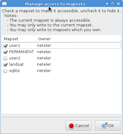
Selecting mapsets with the graphical mapset manager
Using the -s flag, a convenient graphical mapset manager can be opened to select and deselect other mapsets (the actual mapset and the PERMANENT mapset are always selected):g.mapsets -s
Print available mapsets
All available mapsets in the current location can be printed out byg.mapsets -l Available mapsets: PERMANENT user1 user2
Add new mapset
Add mapset 'user2' to the current mapset search pathg.mapsets mapset=user2 operation=add
g.mapsets -p

Accessible mapsets:
user1 user2
Overwrite current search path
Overwrite current search pathg.mapsets mapset=user1,PERMANENT operation=set
Using shortcuts for search path
The current mapset can be defined by a shortcut "." (dot)g.mapsets mapset=.,PERMANENT operation=set
g.mapsets -p

Accessible mapsets:
user1 PERMANENT
SEE ALSO
g.access, g.copy, g.gisenv, g.list, g.mapsetAUTHOR
Michael Shapiro, U.S.Army Construction Engineering Research LaboratoryGreg Koerper, ManTech Environmental Technology, Inc.
Updated to GRASS 7 by Martin Landa, Czech Technical University in Prague, Czech Republic
SOURCE CODE
Available at: g.mapsets source code (history)
Latest change: Wednesday Sep 21 20:58:44 2022 in commit: 13cdec4077e18e93552627735196ff5d1a368188
Main index | General index | Topics index | Keywords index | Graphical index | Full index
© 2003-2023 GRASS Development Team, GRASS GIS 7.8.9dev Reference Manual