Note: This document is for an older version of GRASS GIS that has been discontinued. You should upgrade, and read the current manual page.
NAME
r.patch - Creates a composite raster map layer by using known category values from one (or more) map layer(s) to fill in areas of "no data" in another map layer.KEYWORDS
raster, geometry, mosaicking, merge, patching, aggregation, seriesSYNOPSIS
Flags:
- -z
- Use zero (0) for transparency instead of NULL
- -s
- Do not create color and category files
- --overwrite
- Allow output files to overwrite existing files
- --help
- Print usage summary
- --verbose
- Verbose module output
- --quiet
- Quiet module output
- --ui
- Force launching GUI dialog
Parameters:
- input=name[,name,...] [required]
- Name of raster maps to be patched together
- output=name [required]
- Name for resultant raster map
Table of contents
DESCRIPTION
The GRASS program r.patch allows the user to build a new raster map the size and resolution of the current region by assigning known data values from input raster maps to the cells in this region.In case of overlapping input raster maps this is done by filling in "no data" cells, those that do not yet contain data, contain NULL data, or, optionally contain 0 data, with the data from the first input map. Once this is done the remaining holes are filled in by the next input map, and so on.
In case of adjacent input raster maps the output map contains the map mosaic.
Hence this command is useful for
- making a composite raster map layer from two or more adjacent map layers,
- for filling in "holes" in a raster map layer's data (e.g., in digital elevation data), or
- for updating an older map layer with more recent data.
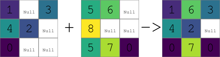
Figure: Result of patching of two raster maps containing NULLs using the default settings.
Stacking order
The first name listed in the string input=name,name,name,... is the name of the first map whose data values will be used to fill in cells in the current region. Then, the second through the last input maps (..., name, name, ...) will be used, in order, to supply data values for the remaining "no data" cells (or cells with value 0 with -z flag).
In other words, the first raster map is used first and if it had some "no data" cells, then second raster map is used for these cells, then the third and so on. So the formal command line syntax can be also written as input=primary,secondary,tertiary,... For two raster maps, the first one can be viewed as the primary one or the default one and the second one as the secondary one or a fallback.
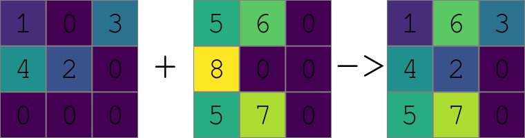
Figure: Result of patching of two raster maps using the -z flag to treat zeros as NULLs. Note the value 1 being preserved from the first raster while the value 6 is taken from the second raster instead of the value 0 from the first raster because zeros are replaced with the -z flag active.
Relation to SQL COALESCE() function
The module is corresponds to the SQL COALESCE() function. This function takes two or more arguments and returns a copy of its first non-NULL argument. If all arguments are NULL, the function returns NULL.The r.patch module iterates over all cells and for each cell of the output raster map uses the first corresponding non-NULL cell in the series of the input raster maps.
Example of filling areas
Below, the raster map layer on the far left is patched with the middle (patching) raster map layer, to produce the composite raster map layer on the right. The example assumes zero values to be treated as NULLs (-z flag).1 1 1 0 2 2 0 0 0 0 1 1 0 0 0 0 1 1 1 1 2 2 0 0 1 1 0 2 2 2 0 0 0 0 1 1 0 0 0 0 1 1 1 2 2 2 0 0 3 3 3 3 2 2 0 0 0 0 0 0 0 0 0 0 3 3 3 3 2 2 0 0 3 3 3 3 0 0 0 0 4 4 4 4 4 4 4 4 3 3 3 3 4 4 4 4 3 3 3 0 0 0 0 0 4 4 4 4 4 4 4 4 3 3 3 4 4 4 4 4 0 0 0 0 0 0 0 0 4 4 4 4 4 4 4 4 4 4 4 4 4 4 4 4
  0 0 1 1 0 0 0 0    1 1 1 0 2 2 0 0    1 1 1 1 2 2 0 0
  0 0 1 1 0 0 0 0    1 1 0 2 2 2 0 0    1 1 1 1 2 2 0 0
  0 0 0 0 0 0 0 0    3 3 3 3 2 2 0 0    3 3 3 3 2 2 0 0
  4 4 4 4 4 4 4 4    3 3 3 3 0 0 0 0    4 4 4 4 4 4 4 4
  4 4 4 4 4 4 4 4    3 3 3 0 0 0 0 0    4 4 4 4 4 4 4 4
  4 4 4 4 4 4 4 4    0 0 0 0 0 0 0 0    4 4 4 4 4 4 4 4
NOTES
Frequently, this program is used to patch together adjacent map layers which have been digitized separately. The program v.mkgrid can be used to make adjacent maps align neatly.The user should check the current geographic region settings before running r.patch, to ensure that the region boundaries encompass all of the data desired to be included in the composite map and to ensure that the region resolution is the resolution of the desired data. To set the geographic region settings to one or several raster maps, the g.region program can be used:
g.region raster=map1[,map2[,...]]
Use of r.patch is generally followed by use of the GRASS programs g.remove and g.rename; g.remove is used to remove the original (un-patched) raster map layers, while g.rename is used to then assign to the newly-created composite (patched) raster map layer the name of the original raster map layer.
r.patch reads the existing category label files and color tables from the input maps and creates these files for the patched, composite output map. This can be quite time consuming for certain maps, especially if there are many different category values across the patched maps. The -s flag allows disabling the reading and creation of these support files, meaning that the output map will have no category labels and no explicit color table.
Number of raster maps to be processed is given by the limit of the operating system. For example, both the hard and soft limits are typically 1024. The soft limit can be changed with e.g. ulimit -n 1500 (UNIX-based operating systems) but not higher than the hard limit. If it is too low, you can as superuser add an entry in
/etc/security/limits.conf
# <domain>      <type>  <item>         <value>
your_username  hard    nofile          1500
Operating systems usually limit the length of the command line which limits the number of input raster maps user can pass to the module using the option input. In that case, r.series can be used instead of r.patch.
EXAMPLES
Example with three maps
The input are three maps called roads, water and forest. Primarily, we want to use the values from roads, then from water and if no other values are available we want to use forest. First we set the computation region assuming that the all three maps fully overlap and have the same resolution (so we can safely use the just the one without further modifications of the region). Then we perform the patching.g.region raster=roads r.patch input=roads,water,forest output=result
Map mosaic example using Bash syntax
Create a list of maps matching a pattern, extend the region to include them all, and patch them together to create a mosaic. Overlapping maps will be used in the order listed.MAPS=`g.list type=raster separator=comma pat="map_*"` g.region raster=$MAPS -p r.patch input=$MAPS output=maps_mosaic
SEE ALSO
g.region, g.remove, g.rename, r.mapcalc, r.support, r.series, v.mkgridHints for large raster data processing
AUTHOR
Michael Shapiro, U.S. Army Construction Engineering Research Laboratory-z flag and performance improvement by Huidae Cho
SOURCE CODE
Available at: r.patch source code (history)
Latest change: Thursday Oct 01 17:35:27 2020 in commit: 744fcaefa6aa37121e72a9530e90b48fa07bef3a
Main index | Raster index | Topics index | Keywords index | Graphical index | Full index
© 2003-2023 GRASS Development Team, GRASS GIS 7.8.9dev Reference Manual