Note: This document is for an older version of GRASS GIS that has been discontinued. You should upgrade, and read the current manual page.
NAME
r.resamp.stats - Resamples raster map layers to a coarser grid using aggregation.KEYWORDS
raster, resample, univariate statistics, aggregationSYNOPSIS
Flags:
- -n
- Propagate NULLs
- -w
- Weight according to area (slower)
- --overwrite
- Allow output files to overwrite existing files
- --help
- Print usage summary
- --verbose
- Verbose module output
- --quiet
- Quiet module output
- --ui
- Force launching GUI dialog
Parameters:
- input=name [required]
- Name of input raster map
- output=name [required]
- Name for output raster map
- method=string
- Aggregation method
- Options: average, median, mode, minimum, maximum, range, quart1, quart3, perc90, sum, variance, stddev, quantile, count, diversity
- Default: average
- quantile=float
- Quantile to calculate for method=quantile
- Options: 0.0-1.0
- Default: 0.5
Table of contents
DESCRIPTION
r.resamp.stats fills a grid cell (raster) matrix with aggregated values generated from a set of input layer data points.
Without the -w switch, the aggregate is computed over all of the input cells whose centers lie within the output cell.
With the -w switch, the aggregate uses the values from all input cells which intersect the output cell, weighted according to the proportion of the source cell which lies inside the output cell. This is slower, but produces a more accurate result.
NOTES
Resampling modules (r.resample, r.resamp.stats, r.resamp.interp, r.resamp.rst) resample the map to match the current region settings.
The notion of weighting doesn't make any sense for the min and max aggregates. However, the -w flag still has significance in that, when multiple destination cells overlap a source cell, the source cell is included in the calculation of all of the destination cells.
EXAMPLE
Resample elevation raster map to a lower resolution (from 6m to 20m; North Carolina sample dataset):
g.region raster=el_D782_6m -p
g.region res=20 -ap
# from 6m to 20m: weighted resampling -w
r.resamp.stats -w input=el_D782_6m output=el_D782_20m
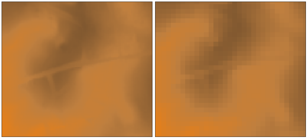
Resampling of 6m DEM (left) to 20m DEM (right) with weighted resampling (subset)
SEE ALSO
g.region, r.resample, r.resamp.rst, r.resamp.filter, r.resamp.interp, r.neighborsOverview: Interpolation and Resampling in GRASS GIS
Examples how statistical functions are applied can be found in the r.neighbors module documentation.
AUTHOR
Glynn ClementsSOURCE CODE
Available at: r.resamp.stats source code (history)
Latest change: Monday Nov 18 20:15:32 2019 in commit: 1a1d107e4f6e1b846f9841c2c6fabf015c5f720d
Main index | Raster index | Topics index | Keywords index | Graphical index | Full index
© 2003-2023 GRASS Development Team, GRASS GIS 7.8.9dev Reference Manual