Note: This document is for an older version of GRASS GIS that has been discontinued. You should upgrade, and read the current manual page.
NAME
r.texture - Generate images with textural features from a raster map.KEYWORDS
raster, algebra, statistics, textureSYNOPSIS
Flags:
- -s
- Separate output for each angle (0, 45, 90, 135)
- Angles are counterclockwise from east: 0 is East to West, 45 is North-East to South-West
- -a
- Calculate all textural measurements
- -n
- Allow NULL cells in a moving window
- This will also avoid cropping along edges of the current region
- --overwrite
- Allow output files to overwrite existing files
- --help
- Print usage summary
- --verbose
- Verbose module output
- --quiet
- Quiet module output
- --ui
- Force launching GUI dialog
Parameters:
- input=name [required]
- Name of input raster map
- output=basename [required]
- Name for output basename raster map(s)
- size=value
- The size of moving window (odd and >= 3)
- Default: 3
- distance=value
- The distance between two samples (>= 1)
- The distance must be smaller than the size of the moving window
- Default: 1
- method=string[,string,...]
- Textural measurement method
- Options: asm, contrast, corr, var, idm, sa, sv, se, entr, dv, de, moc1, moc2
Table of contents
DESCRIPTION
r.texture creates raster maps with textural features from a user-specified raster map layer. The module calculates textural features based on spatial dependence matrices at 0, 45, 90, and 135 degrees.In order to take into account the scale of the texture to be measured, r.texture allows the user to define the size of the moving window and the distance at which to compare pixel grey values. By default the module averages the results over the 4 orientations, but the user can also request output of the texture variables in 4 different orientations (flag -s). Please note that angles are defined in degrees of east and they increase counterclockwise, so 0 is East - West, 45 is North-East - South-West, 90 is North - South, 135 is North-West - South-East.
The user can either chose one or several texture measures (see below for their description) using the method parameter, or can request the creating of maps for all available methods with the -a.
r.texture assumes grey levels ranging from 0 to 255 as input. The input is automatically rescaled to 0 to 255 if the input map range is outside of this range. In order to reduce noise in the input data (thus generally reinforcing the textural features), and to speed up processing, it is recommended that the user recode the data using equal-probability quantization. Quantization rules for r.recode can be generated with r.quantile -r using e.g 16 or 32 quantiles (see example below).
NOTES
Texture is a feature of specific land cover classes in satellite imagery. It is particularly useful in situations where spectral differences between classes are small, but classes are distinguishable by their organisation on the ground, often opposing natural to human-made spaces: cultivated fields vs meadows or golf courses, palm tree plantations vs natural rain forest, but texture can also be a natural phenomen: dune fields, different canopies due to different tree species. The usefulness and use of texture is highly dependent on the resolution of satellite imagery and on the scale of the human intervention or the phenomenon that created the texture (also see the discussion of scale dependency below). The user should observe the phenomenon visually in order to determine an adequat setting of the size parameter.
The output of r.texture can constitute very useful additional variables as input for image classification or image segmentation (object recognition). It can be used in supervised classification algorithms such as i.maxlik or i.smap, or for the identification of objects in i.segment, and/or for the characterization of these objects and thus, for example, as one of the raster inputs of the i.segment.stats addon.
In general, several variables constitute texture: differences in grey level values, coarseness as scale of grey level differences, presence or lack of directionality and regular patterns. A texture can be characterized by tone (grey level intensity properties) and structure (spatial relationships). Since textures are highly scale dependent, hierarchical textures may occur.
r.texture uses the common texture model based on the so-called grey level co-occurrence matrix as described by Haralick et al (1973). This matrix is a two-dimensional histogram of grey levels for a pair of pixels which are separated by a fixed spatial relationship. The matrix approximates the joint probability distribution of a pair of pixels. Several texture measures are directly computed from the grey level co-occurrence matrix.
The following part offers brief explanations of the Haralick et al texture measures (after Jensen 1996).
First-order statistics in the spatial domain
- Sum Average (SA)
- Entropy (ENT): This measure analyses the randomness. It is high when the values of the moving window have similar values. It is low when the values are close to either 0 or 1 (i.e. when the pixels in the local window are uniform).
- Difference Entropy (DE)
- Sum Entropy (SE)
- Variance (VAR): A measure of gray tone variance within the moving window (second-order moment about the mean)
- Difference Variance (DV)
- Sum Variance (SV)
Second-order statistics in the spatial domain
The second-order statistics texture model is based on the so-called grey level co-occurrence matrices (GLCM; after Haralick 1979).- Angular Second Moment (ASM, also called Uniformity):
This is a measure of local homogeneity and the opposite of Entropy.
High values of ASM occur when the pixels in the moving window are
very similar.
Note: The square root of the ASM is sometimes used as a texture measure, and is called Energy. - Inverse Difference Moment (IDM, also called Homogeneity): This measure relates inversely to the contrast measure. It is a direct measure of the local homogeneity of a digital image. Low values are associated with low homogeneity and vice versa.
- Contrast (CON): This measure analyses the image contrast (locally gray-level variations) as the linear dependency of grey levels of neighboring pixels (similarity). Typically high, when the scale of local texture is larger than the distance.
- Correlation (COR): This measure analyses the linear dependency of grey levels of neighboring pixels. Typically high, when the scale of local texture is larger than the distance.
- Information Measures of Correlation (MOC)
- Maximal Correlation Coefficient (MCC)
The computational region should be set to the input map with g.region raster=<input map>, or aligned to the input map with g.region align=<input map> if only a subregion should be analyzed.
Note that the output of r.texture will always be smaller than the current region as only cells for which there are no null cells and for which all cells of the moving window are within the current region will contain a value. The output will thus appear cropped at the margins.
Importantly, the input raster map cannot have more than 255 categories.
EXAMPLE
Calculation of Angular Second Moment of B/W orthophoto (North Carolina data set):g.region raster=ortho_2001_t792_1m -p # set grey level color table 0% black 100% white r.colors ortho_2001_t792_1m color=grey # extract grey levels r.mapcalc "ortho_2001_t792_1m.greylevel = ortho_2001_t792_1m" # texture analysis r.texture ortho_2001_t792_1m.greylevel output=ortho_texture method=asm -s # display g.region n=221461 s=221094 w=638279 e=638694 d.shade color=ortho_texture_ASM_0 shade=ortho_2001_t792_1m
g.region -p raster=ortho_2001_t792_1m

# enter as one line or with \
r.quantile input=ortho_2001_t792_1m quantiles=16 -r | r.recode \
           input=ortho_2001_t792_1m output=ortho_2001_t792_1m_q16 rules=-
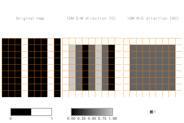
Second example: analysis of IDM (homogeneity) on a simple raster with North-South line pattern.
# import raster
r.in.ascii in=- output=lines << EOF
north: 9
south: 0
east: 9
west: 0
rows: 9
cols: 9
0 0 0 1 0 0 0 1 0
0 0 0 1 0 0 0 1 0
0 0 0 1 0 0 0 1 0
0 0 0 1 0 0 0 1 0
0 0 0 1 0 0 0 1 0
0 0 0 1 0 0 0 1 0
0 0 0 1 0 0 0 1 0
0 0 0 1 0 0 0 1 0
0 0 0 1 0 0 0 1 0
EOF

# adjust region to raster
g.region raster=lines

# calculate IDM (homogeneity) in all directions
r.texture -s lines method=idm output=text_lines
The following image shows the original map, the result in East-West direction and the result in North-South direction, showing how texture can depend on direction, with texture perfectly homogeneous (value=1) in the North-South direction, but quite heterogeneous in East-West direction, except for those areas where there are three columns of equal values (as size=3). The overlaid grid highlights that the texture measures output maps are cropped at the margins.
IDM textures according to direction
KNOWN ISSUES
The program can run incredibly slow for large raster maps and large moving windows (size option).REFERENCES
The algorithm was implemented after Haralick et al., 1973 and 1979.The original code was taken by permission from pgmtexture, part of PBMPLUS (Copyright 1991, Jef Poskanser and Texas Agricultural Experiment Station, employer for hire of James Darrell McCauley). Manual page of pgmtexture. Over the years, the source code of r.texture was further improved.
- Haralick, R.M., K. Shanmugam, and I. Dinstein (1973). Textural features for image classification. IEEE Transactions on Systems, Man, and Cybernetics, SMC-3(6):610-621.
- Bouman, C. A., Shapiro, M. (1994). A Multiscale Random Field Model for Bayesian Image Segmentation, IEEE Trans. on Image Processing, vol. 3, no. 2.
- Jensen, J.R. (1996). Introductory digital image processing. Prentice Hall. ISBN 0-13-205840-5
- Haralick, R. (May 1979). Statistical and structural approaches to texture, Proceedings of the IEEE, vol. 67, No.5, pp. 786-804
- Hall-Beyer, M. (2007). The GLCM Tutorial Home Page (Grey-Level Co-occurrence Matrix texture measurements). University of Calgary, Canada
SEE ALSO
i.maxlik, i.gensig, i.smap, i.gensigset, i.segment.stats, i.pca, r.neighbors, r.rescaleAUTHORS
G. Antoniol - RCOST (Research Centre on Software Technology - Viale Traiano - 82100 Benevento)C. Basco - RCOST (Research Centre on Software Technology - Viale Traiano - 82100 Benevento)
M. Ceccarelli - Facolta di Scienze, Universita del Sannio, Benevento
Markus Metz (correction and optimization of the initial version)
Moritz Lennert (documentation)
SOURCE CODE
Available at: r.texture source code (history)
Latest change: Tuesday Aug 01 09:43:33 2023 in commit: f30418c95f5484b3384e553b5ee7549fc556591f
Main index | Raster index | Topics index | Keywords index | Graphical index | Full index
© 2003-2023 GRASS Development Team, GRASS GIS 7.8.9dev Reference Manual