Note: This document is for an older version of GRASS GIS that has been discontinued. You should upgrade, and read the current manual page.

NAME
r3.in.ascii - Converts a 3D ASCII raster text file into a (binary) 3D raster map.KEYWORDS
raster3d, import, voxel, conversion, ASCIISYNOPSIS
Flags:
- --overwrite
- Allow output files to overwrite existing files
- --help
- Print usage summary
- --verbose
- Verbose module output
- --quiet
- Quiet module output
- --ui
- Force launching GUI dialog
Parameters:
- input=name [required]
- Name of input file to be imported
- '-' for standard input
- output=name [required]
- Name for output 3D raster map
- null_value=string
- String representing NULL value data cell (use 'none' if no such value)
- Default: *
- type=string
- Data type used in the output raster3d map
- Options: default, double, float
- Default: default
- precision=string
- Number of digits used as mantissa in the internal map storage, 0 -23 for float, 0 - 52 for double, max or default
- Default: default
- compression=string
- The compression method used in the output raster3d map
- Options: default, zip, none
- Default: default
- tiledimension=XxYxZ
- The dimensions of the tiles used in the output raster3d map (XxYxZ or default: 16x16x8)
- Default: default
DESCRIPTION
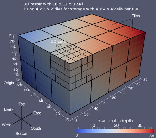
r3.in.ascii allows a user to create a (binary) GRASS 3D raster map layer from a 3D ASCII raster input file.The tiledimension parameter defines the dimension of the tiles used in the output file. The format is: XxYxZ
The nv parameter specifies which value to convert to NULL-value. If the specified value is none, no conversion is performed. Default is none.
NOTES
The data is automatically imported into the correct internal coordinate system, that is visualized in the following picture, independently from the specified ordering in the ASCII input file:
NOTES
The format of the 3D ASCII file:version: "grass7" order: "nsbt" or "nstb" or "snbt" or "sntb" north: floating point south: floating point east: floating point west: floating point top: floating point bottom: floating point rows: integer cols: integer levels: integer
The version and order options are not mandatory. In case no version and order option is specified, the default GRASS 6 ASCII format is assumed.
This header is followed by the cell values in floating point format organized in rows with constant col and level coordinate. The rows are organized by constant level coordinate. Individual cell values are separated by space or CR.
EXAMPLES
4x3x2 sample. Note in case no specific ordering is specified in the input file the upper-left (NW) corner of the bottom level comes first. The according order option is: nsbt for north -> south, bottom -> top ordering. This is identical with r.in.ascii for single level data. So the y coordinate is 0 at the northern edge. north: 3.0south: 0.0
east: 4.0
west: 0.0
top: 2.0
bottom: 0.0
rows: 3
cols: 4
levels: 2
w111x1,y1,z1 w211x2,y1,z1 w311x3,y1,z1 w411x4,y1,z1
w121x1,y2,z1 w221x2,y2,z1 w321x3,y2,z1 w421x4,y2,z1
w131x1,y3,z1 w231x2,y3,z1 w331x3,y3,z1 w431x4,y3,z1
w112x1,y1,z2 w212x2,y1,z2 w312x3,y1,z2 w412x4,y1,z2
w122x1,y2,z2 w222x2,y2,z2 w322x3,y2,z2 w422x4,y2,z2
w132x1,y3,z2 w232x2,y3,z2 w332x3,y3,z2 w432x4,y3,z2
Note that unit tests for r3.in.ascii are implemented in the test.r3.out.ascii.sh script located in the r3.out.ascii directory.
EXAMPLES
Please refer to the detailed examples in r3.out.ascii.AUTHORS
Roman Waupotitsch, Michael Shapiro, Helena Mitasova, Bill Brown, Lubos Mitas, Jaro Hofierka, Sören GebbertSEE ALSO
r.in.ascii, r3.out.ascii, v.to.rast3, g.regionSOURCE CODE
Available at: r3.in.ascii source code (history)
Latest change: Monday Nov 18 20:15:32 2019 in commit: 1a1d107e4f6e1b846f9841c2c6fabf015c5f720d
Main index | 3D raster index | Topics index | Keywords index | Graphical index | Full index
© 2003-2023 GRASS Development Team, GRASS GIS 7.8.9dev Reference Manual