r.forestfrag
Computes the forest fragmentation index (Riitters et al. 2000)
r.forestfrag [-rtsa] input=name output=name [size=number] [pf=name] [pff=name] [memory=memory in MB] [nprocs=integer] [window=integer] [--overwrite] [--verbose] [--quiet] [--qq] [--ui]
Example:
r.forestfrag input=name output=name
grass.tools.Tools.r_forestfrag(input, output, size=3, pf=None, pff=None, memory=300, nprocs=0, window=None, flags=None, overwrite=None, verbose=None, quiet=None, superquiet=None)
Example:
tools = Tools()
tools.r_forestfrag(input="name", output="name")
This grass.tools API is experimental in version 8.5 and expected to be stable in version 8.6.
grass.script.run_command("r.forestfrag", input, output, size=3, pf=None, pff=None, memory=300, nprocs=0, window=None, flags=None, overwrite=None, verbose=None, quiet=None, superquiet=None)
Example:
gs.run_command("r.forestfrag", input="name", output="name")
Parameters
input=name [required]
Name of forest raster map (where forest=1, non-forest=0)
output=name [required]
Name for output raster map
size=number
Moving window size (odd number)
Allowed values: 3-
Default: 3
pf=name
Name for output Pf (forest area density) raster map
Proportion of area which is forested (amount of forest)
pff=name
Name for output Pff (forest connectivity) raster map
Conditional probability that neighboring cell is forest
memory=memory in MB
Maximum memory to be used (in MB)
Cache size for raster rows
Default: 300
nprocs=integer
Number of threads for parallel computing
0: use OpenMP default; >0: use nprocs; <0: use MAX-nprocs
Default: 0
window=integer
This option is deprecated, use the option size instead
Allowed values: 3-
-r
Set computational region to input raster map
-t
Keep Pf and Pff maps
-s
Run r.report on output map
-a
Trim the output map to avoid border effects
--overwrite
Allow output files to overwrite existing files
--help
Print usage summary
--verbose
Verbose module output
--quiet
Quiet module output
--qq
Very quiet module output
--ui
Force launching GUI dialog
input : str | np.ndarray, required
Name of forest raster map (where forest=1, non-forest=0)
Used as: input, raster, name
output : str | type(np.ndarray) | type(np.array) | type(gs.array.array), required
Name for output raster map
Used as: output, raster, name
size : int, optional
Moving window size (odd number)
Used as: number
Allowed values: 3-
Default: 3
pf : str | type(np.ndarray) | type(np.array) | type(gs.array.array), optional
Name for output Pf (forest area density) raster map
Proportion of area which is forested (amount of forest)
Used as: output, raster, name
pff : str | type(np.ndarray) | type(np.array) | type(gs.array.array), optional
Name for output Pff (forest connectivity) raster map
Conditional probability that neighboring cell is forest
Used as: output, raster, name
memory : int, optional
Maximum memory to be used (in MB)
Cache size for raster rows
Used as: memory in MB
Default: 300
nprocs : int, optional
Number of threads for parallel computing
0: use OpenMP default; >0: use nprocs; <0: use MAX-nprocs
Default: 0
window : int, optional
This option is deprecated, use the option size instead
Allowed values: 3-
flags : str, optional
Allowed values: r, t, s, a
r
Set computational region to input raster map
t
Keep Pf and Pff maps
s
Run r.report on output map
a
Trim the output map to avoid border effects
overwrite : bool, optional
Allow output files to overwrite existing files
Default: None
verbose : bool, optional
Verbose module output
Default: None
quiet : bool, optional
Quiet module output
Default: None
superquiet : bool, optional
Very quiet module output
Default: None
Returns:
result : grass.tools.support.ToolResult | np.ndarray | tuple[np.ndarray] | None
If the tool produces text as standard output, a ToolResult object will be returned. Otherwise, None will be returned. If an array type (e.g., np.ndarray) is used for one of the raster outputs, the result will be an array and will have the shape corresponding to the computational region. If an array type is used for more than one raster output, the result will be a tuple of arrays.
Raises:
grass.tools.ToolError: When the tool ended with an error.
input : str, required
Name of forest raster map (where forest=1, non-forest=0)
Used as: input, raster, name
output : str, required
Name for output raster map
Used as: output, raster, name
size : int, optional
Moving window size (odd number)
Used as: number
Allowed values: 3-
Default: 3
pf : str, optional
Name for output Pf (forest area density) raster map
Proportion of area which is forested (amount of forest)
Used as: output, raster, name
pff : str, optional
Name for output Pff (forest connectivity) raster map
Conditional probability that neighboring cell is forest
Used as: output, raster, name
memory : int, optional
Maximum memory to be used (in MB)
Cache size for raster rows
Used as: memory in MB
Default: 300
nprocs : int, optional
Number of threads for parallel computing
0: use OpenMP default; >0: use nprocs; <0: use MAX-nprocs
Default: 0
window : int, optional
This option is deprecated, use the option size instead
Allowed values: 3-
flags : str, optional
Allowed values: r, t, s, a
r
Set computational region to input raster map
t
Keep Pf and Pff maps
s
Run r.report on output map
a
Trim the output map to avoid border effects
overwrite : bool, optional
Allow output files to overwrite existing files
Default: None
verbose : bool, optional
Verbose module output
Default: None
quiet : bool, optional
Quiet module output
Default: None
superquiet : bool, optional
Very quiet module output
Default: None
DESCRIPTION
r.forestfrag Computes the forest fragmentation following the methodology proposed by Riitters et al. (2000). See this article for a detailed explanation.
It follows a "sliding window" algorithm with overlapping windows. The amount of forest and its occurrence as adjacent forest pixels within fixed-area "moving-windows" surrounding each forest pixel is measured. The window size is user-defined. The result is stored at the location of the center pixel. Thus, a pixel value in the derived map refers to "between-pixel" fragmentation around the corresponding forest location.
As input it requires a binary map with (1) forest and (0) non-forest. Obviously, one can replace forest any other land cover type. If one wants to exclude the influence of a specific land cover type, e.g., water bodies, it should be classified as no-data (NA) in the input map. See e.g., blog post.
Let Pf be the proportion of pixels in the window that are forested. Define Pff (strictly) as the proportion of all adjacent (cardinal directions only) pixel pairs that include at least one forest pixel, for which both pixels are forested. Pff thus (roughly) estimates the conditional probability that, given a pixel of forest, its neighbor is also forest. The classification model then identifies six fragmentation categories as:
interior:       Pf = 1.0
patch:          Pf < 0.4
transitional:   0.4 ≤ Pf < 0.6
edge:           Pf ≥ 0.6 and Pf - Pff < 0
perforated:     Pf ≥ 0.6 and Pf - Pff > 0
undetermined:   Pf ≥ 0.6 and Pf = Pff
NOTES
- The moving window size is user-defined (default=3) and must be an odd number. If an even number is given, the function will stop with an error message.
- No-data cells are ignored. This means that statistics at the raster edges are based on fewer cells (smaller) moving windows. If this is a problem, the user can choose to have the output raster trimmed with a number of raster cells equal to 1/2 * the size of the moving window.
- The function respects the region. However, the user has the option to set the region to match the input layer.
EXAMPLE
In the North Carolina sample Location, set the computational region to match the land classification raster map:
g.region raster=landclass96
Then mark all cells which are forest as 1 and everything else as zero:
r.mapcalc "forest = if(landclass96 == 5, 1, 0)"
Use the new forest presence raster map to compute the forest fragmentation index with window size 7:
r.forestfrag input=forest output=fragmentation window=7
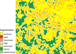
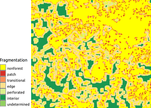
Two forest fragmentation indices with window size 7 (left) and 11 (right) show how increasing window size increases the amount of edges.
SEE ALSO
The addon is based on the r.forestfrag.sh script, with as extra options user-defined moving window size, option to trim the region (by default it respects the region) and a better handling of no-data cells.
REFERENCES
Riitters, K., J. Wickham, R. O'Neill, B. Jones, and E. Smith. 2000. Global-scale patterns of forest fragmentation. Conservation Ecology 4(2): 3. [online] URL: https://www.consecol.org/vol4/iss2/art3/
AUTHORS
Emmanuel Sambale (original shell version)
Stefan Sylla (original shell version)
Paulo van Breugel (Python version, user-defined moving window size)
Vaclav Petras (major code clean up)
SOURCE CODE
Available at: r.forestfrag source code
(history)
Latest change: Wednesday Mar 11 08:17:30 2026 in commit 2a14bbb