NAME
r.out.kde - Exports raster with variable transparency into an image fileKEYWORDS
raster, kernel density, visualization, transparency, heatmapSYNOPSIS
r.out.kde
r.out.kde --helpr.out.kde input=name background=name output=name [method=string] [--overwrite] [--help] [--verbose] [--quiet] [--ui]
Flags:
- --overwrite
- Allow output files to overwrite existing files
- --help
- Print usage summary
- --verbose
- Verbose module output
- --quiet
- Quiet module output
- --ui
- Force launching GUI dialog
Parameters:
- input=name [required]
- Raster map to be rendered with semi-transparency
- background=name [required]
- Background raster map
- output=name [required]
- Rendered output file
- method=string
- Method to scale transparency
- Options: linear, logistic
Table of contents
DESCRIPTION
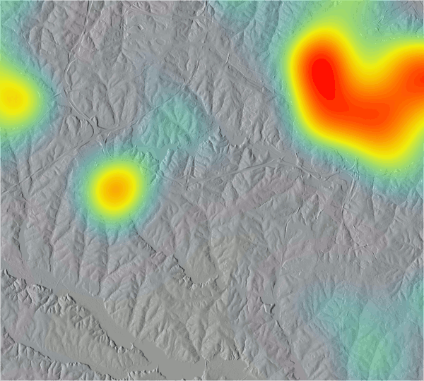
r.out.kde creates an image file (e.g., PNG, JPG, or GIF) where the input raster is rendered on top of background raster with varying transparency based on the values of the input raster. This can be used for example for visualization of kernel density estimate (KDE).With logistic method, values are scaled so that lower values are more transparent and higher values are more opaque than with linear scaling.
This module requires Python Imaging Library (already required for GRASS GIS).
EXAMPLE
In this example, we visualize KDE of schools on top of shaded relief map.g.region raster=elevation # create background map r.relief input=elevation output=relief # compute kernel density estimate v.kernel input=schools_wake output=schools_density radius=4000 multiplier=1000000 r.colors map=schools_density color=bcyr r.out.kde input=schools_density background=relief method=logistic output=output.png
SEE ALSO
d.rast, v.kernelLogistic function
AUTHOR
Anna Petrasova, NCSU GeoForAll labSOURCE CODE
Available at: r.out.kde source code (history)
Latest change: Thu Feb 3 09:32:35 2022 in commit: f17c792f5de56c64ecfbe63ec315307872cf9d5c
Main index | Raster index | Topics index | Keywords index | Graphical index | Full index
© 2003-2022 GRASS Development Team, GRASS GIS 8.0.3dev Reference Manual