NAME
i.albedo - Computes broad band albedo from surface reflectance.KEYWORDS
imagery, albedo, reflectance, satellite, Landsat, ASTER, AVHRR, MODISSYNOPSIS
i.albedo
i.albedo --helpi.albedo [-mnl8acd] input=name[,name,...] output=name [--overwrite] [--help] [--verbose] [--quiet] [--ui]
Flags:
- -m
- MODIS (7 input bands:1,2,3,4,5,6,7)
- -n
- NOAA AVHRR (2 input bands:1,2)
- -l
- Landsat 5+7 (6 input bands:1,2,3,4,5,7)
- -8
- Landsat 8 (7 input bands:1,2,3,4,5,6,7)
- -a
- ASTER (6 input bands:1,3,5,6,8,9)
- -c
- Aggressive mode (Landsat)
- Albedo dry run to calculate some water to beach/sand/desert stretching, a kind of simple atmospheric correction
- -d
- Soft mode (MODIS)
- Albedo dry run to calculate some water to beach/sand/desert stretching, a kind of simple atmospheric correction
- --overwrite
- Allow output files to overwrite existing files
- --help
- Print usage summary
- --verbose
- Verbose module output
- --quiet
- Quiet module output
- --ui
- Force launching GUI dialog
Parameters:
- input=name[,name,...] [required]
- Name of input raster map
- output=name [required]
- Name for output raster map
Table of contents
DESCRIPTION
i.albedo calculates the albedo, that is the Shortwave surface reflectance in the range of 0.3-3 micro-meters. It takes as input individual bands of surface reflectance originating from MODIS, AVHRR, Landsat or Aster satellite sensors and calculates the albedo for those. This is a precursor to r.sun and any energy-balance processing.NOTES
It uses for Landsat 8 the weighted average reflectance (temporary solution until an algorithm is found).It assumes MODIS product surface reflectance in [0;10000].
EXAMPLE
The following example creates the raster map "albedo_lsat7_1987" from the LANDSAT-TM5 bands in the North Carolina dataset:g.region raster=lsat5_1987_10 -p i.albedo -l input=lsat5_1987_10,lsat5_1987_20,lsat5_1987_30,lsat5_1987_40,lsat5_1987_50,lsat5_1987_70 output=albedo_lsat7_1987
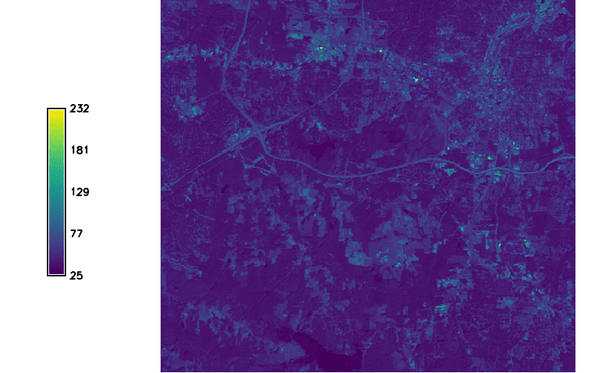
Figure: Resulting albedo map from LANDSAT 5
The following example creates the raster map "albedo_lsat7_2000" from the LANDSAT-TM7 bands in the North Carolina dataset:
g.region raster=lsat7_2000_10 -p
i.albedo -l input=lsat7_2000_10,lsat7_2000_20,lsat7_2000_30,lsat7_2000_40,lsat7_2000_50,lsat7_2000_70 output=albedo_lsat7_2000
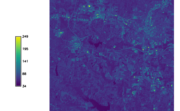
Figure: Resulting albedo map from LANDSAT 7
TODO
Maybe change input requirement of MODIS to [0.0-1.0]?References
For a 2 band determination of the Aster BB Albedo see the following:Salleh and Chan, 2014. Land Surface Albedo Determination: Remote Sensing and Statistical Validation. in proceedings of FIG 2014 (PDF)
SEE ALSO
r.sun, i.viAUTHOR
Yann CheminSOURCE CODE
Available at: i.albedo source code (history)
Latest change: Thu Feb 3 11:10:06 2022 in commit: 73413160a81ed43e7a5ca0dc16f0b56e450e9fef
Main index | Imagery index | Topics index | Keywords index | Graphical index | Full index
© 2003-2022 GRASS Development Team, GRASS GIS 8.0.3dev Reference Manual