NAME
i.pca - Principal components analysis (PCA) for image processing.KEYWORDS
imagery, transformation, PCA, principal components analysisSYNOPSIS
Flags:
- -n
- Normalize (center and scale) input maps
- Default: center only
- -f
- Output will be filtered input bands
- Apply inverse PCA after PCA
- --overwrite
- Allow output files to overwrite existing files
- --help
- Print usage summary
- --verbose
- Verbose module output
- --quiet
- Quiet module output
- --ui
- Force launching GUI dialog
Parameters:
- input=name[,name,...] [required]
- Name of two or more input raster maps or imagery group
- output=basename [required]
- Name for output basename raster map(s)
- A numerical suffix will be added for each component map
- rescale=min,max
- Rescaling range for output maps
- For no rescaling use 0,0
- Default: 0,255
- percent=integer
- Cumulative percent importance for filtering
- Options: 50-99
- Default: 99
Table of contents
DESCRIPTION
i.pca is an image processing program based on the algorithm provided by Vali (1990), that processes n (n >= 2) input raster map layers and produces n output raster map layers containing the principal components of the input data in decreasing order of variance ("contrast"). The output raster map layers are assigned names with .1, .2, ... .n suffixes. The numbers used as suffix correspond to percent importance with .1 being the scores of the principal component with the highest importance.The current geographic region definition and MASK settings are respected when reading the input raster map layers. When the rescale option is used, the output files are rescaled to fit the min,max range.
The order of the input bands does not matter for the output maps (PC scores), but does matter for the vectors (loadings), since each loading refers to a specific input band.
If the output is not rescaled (rescale=0,0, the output raster maps will be of type DCELL, otherwise the output raster maps will be of type CELL.
By default, the values of the input raster maps are centered for each map separately with x - mean. With -n, the input raster maps are normalized for each map separately with (x - mean) / stddev. Normalizing is highly recommended when the input raster maps have different units, e.g. represent different environmental parameters.
The -f flag, together with the percent option, can be used to remove noise from input bands. Input bands will be recalculated from a subset of the principal components (inverse PCA). The subset is selected by using only the most important (highest eigenvalue) principal components which explain together percent percent variance observed in the input bands.
NOTES
Richards (1986) gives a good example of the application of principal components analysis (PCA) to a time series of LANDSAT images of a burned region in Australia.Eigenvalue and eigenvector information is stored in the output maps' history files. View with r.info.
EXAMPLE
PCA calculation using Landsat7 imagery in the North Carolina sample dataset:
g.region raster=lsat7_2002_10 -p
i.pca in=lsat7_2002_10,lsat7_2002_20,lsat7_2002_30,lsat7_2002_40,lsat7_2002_50,lsat7_2002_70 \
    out=lsat7_2002_pca

r.info -h lsat7_2002_pca.1
   Eigen values, (vectors), and [percent importance]:
   PC1   4334.35 ( 0.2824, 0.3342, 0.5092,-0.0087, 0.5264, 0.5217) [83.04%]
   PC2    588.31 ( 0.2541, 0.1885, 0.2923,-0.7428,-0.5110,-0.0403) [11.27%]
   PC3    239.22 ( 0.3801, 0.3819, 0.2681, 0.6238,-0.4000,-0.2980) [ 4.58%]
   PC4     32.85 ( 0.1752,-0.0191,-0.4053, 0.1593,-0.4435, 0.7632) [ 0.63%]
   PC5     20.73 (-0.6170,-0.2514, 0.6059, 0.1734,-0.3235, 0.2330) [ 0.40%]
   PC6      4.08 (-0.5475, 0.8021,-0.2282,-0.0607,-0.0208, 0.0252) [ 0.08%]

d.mon wx0
d.rast lsat7_2002_pca.1
# ...
d.rast lsat7_2002_pca.6
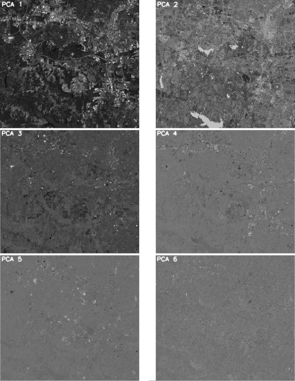
Resulting PCA maps calculated from the Landsat7 imagery (NC, USA)
SEE ALSO
Richards, John A., Remote Sensing Digital Image Analysis, Springer-Verlag, 1986.Vali, Ali R., Personal communication, Space Research Center, University of Texas, Austin, 1990.
i.cca,
g.gui.iclass,
i.fft,
i.ifft,
m.eigensystem,
r.covar,
r.mapcalc
Principal Components Analysis article
(GRASS Wiki)
Major modifications for GRASS 4.1 were made by Rewritten for GRASS 6.x and major modifications by
Available at:
i.pca source code
(history)
Latest change: Thu Feb 3 11:10:06 2022 in commit: 73413160a81ed43e7a5ca0dc16f0b56e450e9fef
Main index |
Imagery index |
Topics index |
Keywords index |
Graphical index |
Full index
© 2003-2022
GRASS Development Team,
GRASS GIS 8.0.3dev Reference Manual
AUTHORS
David Satnik, GIS Laboratory
Olga Waupotitsch and
Michael Shapiro,
U.S.Army Construction Engineering
Research Laboratory
Brad DouglasSOURCE CODE