NAME
i.spectral - Displays spectral response at user specified locations in group or images.KEYWORDS
imagery, querying, raster, multispectralSYNOPSIS
i.spectral
i.spectral --helpi.spectral [-cgt] [group=name] [subgroup=name] [raster=name[,name,...]] coordinates=east,north[,east,north,...] [output=name] [format=string] [--overwrite] [--help] [--verbose] [--quiet] [--ui]
Flags:
- -c
- Show sampling coordinates instead of numbering in the legend (valid for -g flag)
- -g
- Use gnuplot for display
- -t
- output to text file
- --overwrite
- Allow output files to overwrite existing files
- --help
- Print usage summary
- --verbose
- Verbose module output
- --quiet
- Quiet module output
- --ui
- Force launching GUI dialog
Parameters:
- group=name
- Name of input imagery group
- subgroup=name
- Name of input imagery subgroup
- raster=name[,name,...]
- Name of input raster map(s)
- coordinates=east,north[,east,north,...] [required]
- Coordinates
- output=name
- Name for output image is valid for -g (or text file for -t flag)
- format=string
- Graphics format for output file (valid for -g flag)
- Options: png, eps, svg
- Default: png
Table of contents
DESCRIPTION
i.spectral displays spectral response at user specified locations in images.NOTES
This script requires the launch of one of the supported monitors (cairo, png, ps) or gnuplot to be installed.EXAMPLE
Analysis of LANDSAT TM7 channels (North Carolina dataset):
g.region raster=lsat7_2002_10 -p
i.spectral -g raster=lsat7_2002_10,lsat7_2002_20,lsat7_2002_30,lsat7_2002_40,lsat7_2002_50,lsat7_2002_70 \
           coordinates=636069,215440,637958,223393,633277,223605
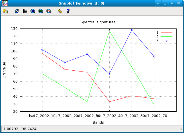
Spectral plot of 3 different land cover types: (1) water, (2) green vegetation, and (3) highway
North Carolina sample dataset:
g.region raster=lsat7_2002_10 -p
LIST=`g.list type=raster pattern="lsat7_2002_[1-5,7]0" separator=","`
d.mon start=cairo output=plot.png
i.spectral raster=$LIST coordinates=637502.25,221744.25
d.mon stop=cairo
SEE ALSO
d.where, r.what, Cairo driver, PNG driver, PS driver (Postscript)AUTHORS
Markus NetelerFrancesco Pirotti
SOURCE CODE
Available at: i.spectral source code (history)
Latest change: Thu Feb 3 11:10:06 2022 in commit: 73413160a81ed43e7a5ca0dc16f0b56e450e9fef
Main index | Imagery index | Topics index | Keywords index | Graphical index | Full index
© 2003-2022 GRASS Development Team, GRASS GIS 8.0.3dev Reference Manual