NAME
r.li.cwed - Calculates contrast weighted edge density index on a raster mapKEYWORDS
raster, landscape structure analysis, patch indexSYNOPSIS
r.li.cwed
r.li.cwed --helpr.li.cwed input=name config=name path=name output=name [--overwrite] [--help] [--verbose] [--quiet] [--ui]
Flags:
- --overwrite
- Allow output files to overwrite existing files
- --help
- Print usage summary
- --verbose
- Verbose module output
- --quiet
- Quiet module output
- --ui
- Force launching GUI dialog
Parameters:
- input=name [required]
- Name of input raster map
- config=name [required]
- Configuration file
- path=name [required]
- Name of file that contains the weight to calculate the index
- output=name [required]
- Name for output raster map
Table of contents
DESCRIPTION
r.li.cwed (contrast weighted edge density) calculates the edge density between patch types specified: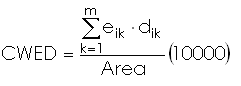
with:
- k: attribute
- m: number of non-null attributes in the sampling area
- eik: total length of edge in landscape between patch types i and k
- dik: dissimilarity (edge contrast weight) between patch types i and k
- Area: total landscape area
The input file contains a row for each couple of patch type that we want to consider in the calculation. Each row must be saved using this syntax:
patchType1,patchType2,dissimilarityBetweenPatchType1andPatchType2
NOTES
Do not use absolute path names for the config and output file/map parameters. If the "moving window" method was selected in g.gui.rlisetup, then the output will be a raster map, otherwise an ASCII file will be generated in the folder C:\Users\userxy\AppData\Roaming\GRASS8\r.li\output\ (MS-Windows) or $HOME/.grass8/r.li/output/ (GNU/Linux).
If the sample area contains only NULL values it is considered to
have 0 patch and CWED=0. If Area is 0 r.li.cwed returns -1.
This is only possible if the map is masked.
If you want to change these -1 values to NULL, run subsequently on the resulting map:
r.null setnull=-1 input=my_map
EXAMPLES
To calculate the contrast weighted edge density index on map my_map, using my_conf configuration file (previously defined with g.gui.rlisetup) and saving results in my_out, run:
r.li.cwed input=my_map conf=my_conf output=my_out \
          path=/path/to/weights.csv
Example for input "weights.csv" file:
12,16,0.65
44,123,0.32
56,12,0.54
23,66,0.99
SEE ALSO
r.li - package overviewg.gui.rlisetup
REFERENCES
McGarigal, K., and B. J. Marks. 1995. FRAGSTATS: spatial pattern analysis program for quantifying landscape structure. USDA For. Serv. Gen. Tech. Rep. PNW-351. (PDF)AUTHORS
Serena Pallecchi student of Computer Science University of Pisa (Italy).Commission from Faunalia Pontedera (PI), Italy (www.faunalia.it)
Markus Metz
SOURCE CODE
Available at: r.li.cwed source code (history)
Latest change: Thu Feb 3 11:10:06 2022 in commit: 73413160a81ed43e7a5ca0dc16f0b56e450e9fef
Main index | Raster index | Topics index | Keywords index | Graphical index | Full index
© 2003-2022 GRASS Development Team, GRASS GIS 8.0.3dev Reference Manual