NAME
r3.to.rast - Converts 3D raster maps to 2D raster mapsKEYWORDS
raster3d, conversion, raster, voxelSYNOPSIS
r3.to.rast
r3.to.rast --helpr3.to.rast [-mr] input=string output=string [type=string] [multiply=float] [add=float] [--overwrite] [--help] [--verbose] [--quiet] [--ui]
Flags:
- -m
- Use 3D raster mask (if exists) with input map
- -r
- Use the same resolution as the input 3D raster map for the 2D output maps, independent of the current region settings
- --overwrite
- Allow output files to overwrite existing files
- --help
- Print usage summary
- --verbose
- Verbose module output
- --quiet
- Quiet module output
- --ui
- Force launching GUI dialog
Parameters:
- input=string [required]
- 3D raster map(s) to be converted to 2D raster slices
- output=string [required]
- Basename for resultant raster slice maps
- type=string
- Type of raster map to be created
- Storage type for resultant raster map
- Options: CELL, FCELL, DCELL
- CELL: Integer
- FCELL: Single precision floating point
- DCELL: Double precision floating point
- multiply=float
- Value to multiply the raster values with
- Coefficient a in the equation y = ax + b
- add=float
- Value to add to the raster values
- Coefficient b in the equation y = ax + b
Table of contents
DESCRIPTION
Converts one 3D raster map into several 2D raster maps (depends on depths). If the 2D and 3D region settings are different, the 3D resolution will be adjusted to the 2D resolution (the depths are not touched). The user can force r3.to.rast to use the 2D resolution of the input 3D raster map for the output maps, independently from the current region settings.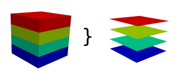
Map type conversions
Type of resulting 2D raster maps is determined by the type of the input 3D raster, i.e. 3D raster of type DCELL (double) will result in DCELL 2D rasters. A specific type for 2D rasters can be requested using the type option.The type option is especially advantageous when the 3D raster map stores categories (which need to be stored as floating point numbers) and the 2D raster map should be also categorical, i.e. use integers. The type is set to CELL in this case.
Modifying the values
The values in the 3D raster map can be modified prior to storing in the 2D raster map. The values can be scaled using the option multiply and a constant value can be added using the option add. The new value is computed using the following equation:y = ax + bwhere x is the original value, a is the value of multiply option, b is the value of add option, and y is the new value. When multiply is not provided, the value of a is 1. When add is not provided, the value of b is 0.
NOTES
Every slice of the 3D raster map is copied to one 2D raster map. The maps are named like output_slicenumber. Slices are counted from bottom to the top, so the bottom slice has number 1.The number of slices is equal to the number of depths.
To round floating point values to integers when using type=CELL, the add option should be set to 0.5.
SEE ALSO
r3.cross.rast, r3.out.vtk, r3.out.ascii, g.regionAUTHORS
Sören Gebbert Vaclav Petras, NCSU GeoForAll LabSOURCE CODE
Available at: r3.to.rast source code (history)
Latest change: Thu Feb 3 11:10:06 2022 in commit: 73413160a81ed43e7a5ca0dc16f0b56e450e9fef
Main index | 3D raster index | Topics index | Keywords index | Graphical index | Full index
© 2003-2022 GRASS Development Team, GRASS GIS 8.0.3dev Reference Manual