Note: This document is for an older version of GRASS GIS that will be discontinued soon. You should upgrade, and read the current manual page.
NAME
r.green.hydro.delplants - Delete segments where there is an existing plantKEYWORDS
SYNOPSIS
r.green.hydro.delplants
r.green.hydro.delplants --helpr.green.hydro.delplants [-d] hydro=name [hydro_layer=string] river=name output_streams=string [output_plants=string] [hydro_kind_intake=string] [hydro_kind_turbine=string] elevation=name [other=name] [other_layer=name] [other_kind_intake=string] [other_kind_turbine=string] [--overwrite] [--help] [--verbose] [--quiet] [--ui]
Flags:
- -d
- Debug with intermediate maps
- --overwrite
- Allow output files to overwrite existing files
- --help
- Print usage summary
- --verbose
- Verbose module output
- --quiet
- Quiet module output
- --ui
- Force launching GUI dialog
Parameters:
- hydro=name [required]
- Name of the vector map with the points (intake and restitution) of hydropower plants
- Or data source for direct OGR access
- hydro_layer=string
- Name of the vector map layer of the hydropower plants, with the following attributes: kind_label (intake/restitution), discharge [m3/s], id_point, id_plant
- Vector features can have category values in different layers. This number determines which layer to use. When used with direct OGR access this is the layer name.
- Default: 1
- river=name [required]
- Name of the vector map with the streams
- Or data source for direct OGR access
- output_streams=string [required]
- Name of the vector map with the stream segments without plants
- output_plants=string
- Name of the vector map with the stream segments of the existing plants
- hydro_kind_intake=string
- Value contained in the column kind_label that indicates the plant is an intake
- Default: intake
- hydro_kind_turbine=string
- Value contained in the column kind_label that indicates the plant is a restitution
- Default: restitution
- elevation=name [required]
- Name of input elevation raster map
- other=name
- Name of the vector map with points (intake and restitution) of other plants such as irrigation, acqueducts, etc.
- Or data source for direct OGR access
- other_layer=name
- Name of the vector map layer of other plants, with the following attributes: kind_label (intake/restitution), discharge [m3/s], id_point, id_plant
- Or data source for direct OGR access
- Default: 1
- other_kind_intake=string
- Value contained in the column kind_label that indicates the plant is an intake
- Default: intake
- other_kind_turbine=string
- Value contained in the column kind_label that indicates the plant is a restitution
- Default: restitution
Table of contents
DESCRIPTION
r.green.hydro.delplants deletes segments of river where there is an existing plant.NOTES
This command is used to select the segments of river which are not already exploited by a plant or another structure.The required inputs are the elevation raster map, the map with the streams and the one with the intakes and restitution of the existing plants. In option, it is possible to add the map with the intakes and restitution of the other structures such aqueducts or irrigation in order to delete these segments too.
It is necessary to verify in "Optional" that the intakes and restitution are well reported in the table of the input maps (hydro and other).
EXAMPLE
This example is based on the case-study of Mis valley in Belluno province, Veneto, Italy.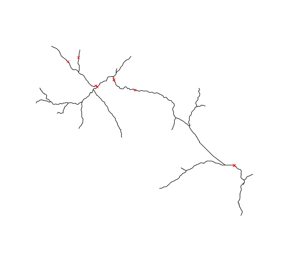
Input vector maps : streams of Mis Valley in black and intakes and restitution of existing plants in red
We use the following code to compute the available streams and obtain the next map :
r.green.hydro.delplants hydro=existingplants river=streams output=availablestreams elevation=elevation

d.vect map=existingplants color=red
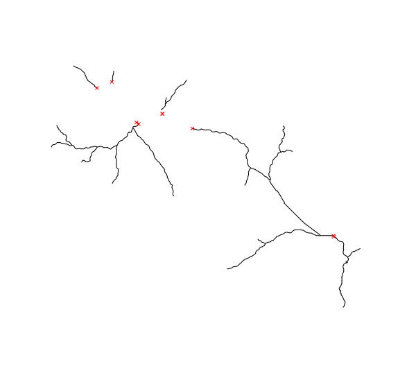
Output vector map in black : streams of Mis Valley without the existing plants (intakes and restitution of existing plants are added there in red)
SEE ALSO
r.green.hydro.discharger.green.hydro.financial
r.green.hydro.theoretical
r.green.hydro.optimal
r.green.hydro.recommended
r.green.hydro.structure
r.green.hydro.technical
AUTHORS
Giulia Garegnani and Pietro Zambelli (Eurac Research, Bolzano, Italy), Manual written by Julie Gros.SOURCE CODE
Available at: r.green.hydro.delplants source code (history)
Latest change: Monday Jan 30 19:52:26 2023 in commit: cac8d9d848299297977d1315b7e90cc3f7698730
Note: This document is for an older version of GRASS GIS that will be discontinued soon. You should upgrade, and read the current manual page.
Main index | Raster index | Topics index | Keywords index | Graphical index | Full index
© 2003-2023 GRASS Development Team, GRASS GIS 8.2.2dev Reference Manual