Note: This document is for an older version of GRASS GIS that will be discontinued soon. You should upgrade, and read the current manual page.
NAME
r.in.ahn - Imports the 0.5 meter resolution dtm or dsm from the AHN (Actueel Hoogtebestand Nederland (AHN), version 4.KEYWORDS
dem, raster, importSYNOPSIS
Flags:
- -t
- Download whole tiles
- Download the selected product for the AHN tile that overlap with the current region. If enabled, a vector layer with the bounds of the AHN tiles will be saved, using the output name with as suffix _tiles
- -g
- Set to original computational region
- After downloading and importing the requested layer, set the region back to the original computation region.
- --overwrite
- Allow output files to overwrite existing files
- --help
- Print usage summary
- --verbose
- Verbose module output
- --quiet
- Quiet module output
- --ui
- Force launching GUI dialog
Parameters:
- product=string [required]
- product
- Choose which product to download (dsm or dtm)
- Options: dsm, dtm
- output=name [required]
- Name for output raster map
Table of contents
DESCRIPTION
r.in.ahn imports the Actueel Hoogtebestand Nederland (AHN, version 4) for the current region. The AHN is a digital elevation model (DEM) of the Netherlands with a resolution of of 0.5 meter.There are two different layers available: the digital terrain model (DTM) and a digital surface model (DSM). The user needs to select which to download. The selected product will be downloaded for the computation region. However, note that the region will adjusted to ensure that the imported raster layer neatly aligns with and has the same resolution (0.5 meter) as the original AHN data. The resulting will always have the same or a larger extent than the original computation region. If you want to store the current computational region, make sure to first save it using g.region.
The AHN can also be downloaded in map sheets (tiles) of 6.5 by 5 kilometer. To download the area covered by one or more of these tiles, the user can set the -t flag. This wil to download the area for the tiles that overlap with the current computational region.
NOTE
This location only works in a location with the project 'RD New' (EPSG:28992). Attempts to run it in a location with another CRS will result in an error message.The region will be adjusted to ensure that the imported raster layer neatly aligns with and has the same resolution (0.5 meter) as the original AHN data. The user can set the -g flag to return the region to the original computation region after the data is imported.
The addon uses the r.in.wcs addon in the background, so the user will first need to install this addon.
EXAMPLE
Example 1
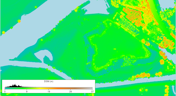
Import the DTM for Fort Crèvecoeur, an fortress where the river Old Dieze flows into the Maas river.
# Set the region for Fort Crèvecoeur
g.region n=416562 s=415957 w=145900 e=147003 res=0.5

# Download the DSM
r.in.ahn product=dsm output=dsm_crevecoeur
Example 2
Import the DTM for the tile that overlaps with the current region. Do this by setting the -t flag.
# Set the region for Fort Crèvecoeur
g.region n=416562 s=415957 w=145900 e=147003 res=0.5

# Download the DSM
r.in.ahn -t product=dsm output=dsm_crevecoeur2
The result will be a raster layer dsm_crevecoeur2 and a vector layer dsm_crevecoeur2_tiles

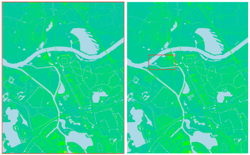
Figure: DSM map of Fort Crèvecoeur. Left shows the extent (red outline) after running example 2. The extent equals the extent of the area (tile) for which the data was downloaded. Right shows the extent (red outline) after running example 3. In this case, the extent is the same as before running the example because the -g flag was set.
Example 3
Set the -t flag to import the DTM for the tile that overlaps with the current region. Set the -g flag to keep the current computation region after importing the requested data. Note, the imported data will still have the resolution of, and will be aligned to, the original AHN data.
# Set the region for Fort Crèvecoeur
g.region n=416562 s=415957 w=145900 e=147003 res=0.5

# Download the DSM
r.in.ahn -t -g product=dsm output=dsm_crevecoeur3
The result will be a raster layer dsm_crevecoeur3 and a vector layer dsm_crevecoeur3_tiles
REFERENCES
See the AHN webpage for more information about the AHN data (in Dutch).AUTHORS
Paulo van Breugel | HAS green academy, University of Applied Sciences | Climate-robust Landscapes research group | Innovative Bio-Monitoring research group | Contact: Ecodiv.earthSOURCE CODE
Available at: r.in.ahn source code (history)
Latest change: Monday Jun 24 08:16:48 2024 in commit: 8939a985d18de5366340b88037ab0fe3a0814c9b
Note: This document is for an older version of GRASS GIS that will be discontinued soon. You should upgrade, and read the current manual page.
Main index | Raster index | Topics index | Keywords index | Graphical index | Full index
© 2003-2023 GRASS Development Team, GRASS GIS 8.2.2dev Reference Manual
