Note: This document is for an older version of GRASS GIS that will be discontinued soon. You should upgrade, and read the current manual page.
NAME
r.to.vect.lines - Convert raster rows to vector lines.KEYWORDS
raster, conversion, wigglesSYNOPSIS
Flags:
- -v
- Sample vertically (default is to sample horizontally)
- --overwrite
- Allow output files to overwrite existing files
- --help
- Print usage summary
- --verbose
- Verbose module output
- --quiet
- Quiet module output
- --ui
- Force launching GUI dialog
Parameters:
- input=name [required]
- Name of input raster map
- output=name [required]
- Name for output vector map
- skip=integer
- Sample every Nth grid row
- Options: 1-100000
- Default: 10
NOTES
Extracts rows from a raster map as 3D vector lines.Reads a raster map, writes to a vector map.
Doesn't check if output map already exists. (fixme)
The category given to the line refers to the row number. (starting with category 0!)
Nulls within a row are skipped, so holes will be filled by a straight line. (fixme) Nulls at the ends of lines are not included in the output line.
Nulls are not handled very well and may sneak through as very negative numbers. (fixme)
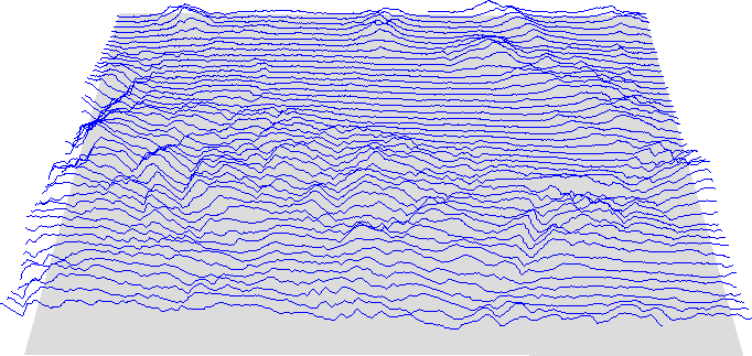
EXAMPLE
Display a wiggle plot in NVIZ:(Spearfish dataset)
g.region raster=elevation.dem
r.to.vect.lines.py in=elevation.dem out=wiggle_lines
eval `v.info -g wiggle_lines`
r.mapcalc "floor = $bottom"
nviz elev=floor vector=wiggle_lines

# alternative
m.nviz.image elevation_map=floor vline=wiggle_lines resolution_fine=1 \
  zexag=20 out=wiggle.png perspective=5
SEE ALSO
r.to.vect, v.in.linesAUTHOR
Hamish BowmanDept. of Geology
University of Otago
Dunedin, New Zealand
SOURCE CODE
Available at: r.to.vect.lines source code (history)
Latest change: Thursday Feb 03 09:32:35 2022 in commit: f17c792f5de56c64ecfbe63ec315307872cf9d5c
Note: This document is for an older version of GRASS GIS that will be discontinued soon. You should upgrade, and read the current manual page.
Main index | Raster index | Topics index | Keywords index | Graphical index | Full index
© 2003-2023 GRASS Development Team, GRASS GIS 8.2.2dev Reference Manual