Note: This document is for an older version of GRASS GIS that will be discontinued soon. You should upgrade, and read the current manual page.
NAME
i.tasscap - Performs Tasseled Cap (Kauth Thomas) transformation.KEYWORDS
imagery, transformation, Landsat, MODIS, Worldview, Sentinel, Tasseled Cap transformationSYNOPSIS
Flags:
- --overwrite
- Allow output files to overwrite existing files
- --help
- Print usage summary
- --verbose
- Verbose module output
- --quiet
- Quiet module output
- --ui
- Force launching GUI dialog
Parameters:
- input=name[,name,...] [required]
- For Landsat4-7: bands 1, 2, 3, 4, 5, 7; for Landsat8: bands 2, 3, 4, 5, 6, 7; for MODIS: bands 1, 2, 3, 4, 5, 6, 7; for Sentinel-2: bands 1 to 12, 8A; for Worldview-2: bands 1, 2, 3, 4, 5, 6, 7, 8
- output=basename [required]
- basename for output raster map(s)
- Name for output basename raster map(s)
- sensor=string [required]
- Satellite sensor
- Options: landsat4_tm, landsat5_tm, landsat7_etm, landsat8_oli, modis, sentinel2, worldview2
Table of contents
DESCRIPTION
i.tasscap calculates Tasseled Cap (Kauth Thomas, TC) transformation for Landsat TM data (TM4, TM5, ETM7), MODIS and Sentinel-2 data. The tasseled cap transformation is effectively a compression method to reduce multiple spectral data into a few bands. The method was originally developed for understanding important phenomena of crop development in spectral space (Kauth and Thomas, 1976).Tasseled cap coefficients for Landsat 7 ETM+ are at-satellite reflectance values (C. Huang et al., 2001), the conversion can be achieved with i.landsat.toar.
The following tasseled cap components are generated:
- tasscap.1: corresponds to brightness,
- tasscap.2: corresponds to greenness,
- tasscap.3: corresponds to wetness,
- tasscap.4: corresponds to atmospheric haze (only selected sensors: Landsat 5,7,8).
EXAMPLE
Calculation of TC maps from North Carolina Landsat 7 ETM scene:# See manual page of i.landsat.toar for pre-processing g.region raster=lsat7_2002_toar.1 -p i.tasscap sensor=landsat7_etm \ input=lsat7_2002_toar.1,lsat7_2002_toar.2,lsat7_2002_toar.3,lsat7_2002_toar.4,lsat7_2002_toar.5,lsat7_2002_toar.7 \ output=lsat7_2002_tasscap
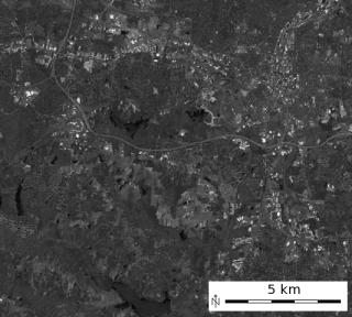
'Brightness' Tasseled Cap component 1 |
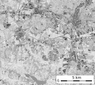
'Greenness' Tasseled Cap component 2 |
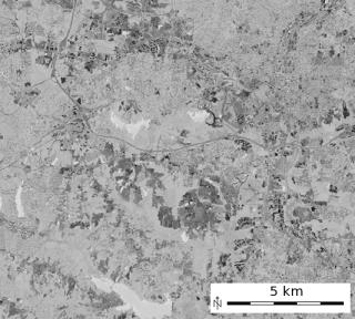
'Wetness' Tasseled Cap component 3 |
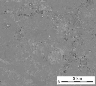
'Atmospheric haze' Tasseled Cap component 4 |
REFERENCES
- LANDSAT-4/LANDSAT-5: TC-factor changed to CRIST et al. 1986, Proc. IGARSS 1986, p.1467
- Crist, E. P., 1985, A TM tasseled cap equivalent transformation for reflectance factor data, Remote Sensing of Environment, 17: 301-306.
- LANDSAT-7: TASSCAP factors cited from: DERIVATION OF A TASSELED CAP TRANSFORMATION BASED ON LANDSAT 7 AT-SATELLITE REFLECTANCE. Chengquan Huang, Bruce Wylie, Limin Yang, Collin Homer and Gregory Zylstra Raytheon ITSS, USGS EROS Data Center Sioux Falls, SD 57198, USA (http://landcover.usgs.gov/pdf/tasseled.pdf). This is published as well in INT. J. OF RS, 2002, VOL 23, NO. 8, 1741-1748.
- MODIS Tasseled Cap coefficients - Ref: Lobser & Cohen (2007). MODIS tasseled cap: land cover characteristics expressed through transformed MODIS data. International Journal of Remote Sensing, Volume 28(22), Table 3
- Sentinel-2 Tasseled Cap coefficients - Ref: Nedkov, R. (2017). Orthogonal transformation of segmented images from the satellite Sentinel-2. Comptes rendus de l'Académie bulgare des sciences, 70:687-692.
- Yarbrough, L., Navulur, R., 2014, Presentation of the Kauth-Thomas transform for WorldView-2 reflectance data. Remote Sensing Letters. 5. DOI: 10.1080/2150704X.2014.885148.
SEE ALSO
i.albedo, i.atcorr, i.landsat.toar, i.viAUTHORS
Dr. Agustin Lobo, original script, 1997Markus Neteler, ITC-irst, 2001
Converted to Python by Glynn Clements
Code improvements by Leonardo Perathoner
Sentinel-2 support by Veronica Andreo
Worldview-2 support by Markus Neteler
SOURCE CODE
Available at: i.tasscap source code (history)
Latest change: Thursday Feb 03 11:10:06 2022 in commit: 547ff44e6aecfb4c9cbf6a4717fc14e521bec0be
Note: This document is for an older version of GRASS GIS that will be discontinued soon. You should upgrade, and read the current manual page.
Main index | Imagery index | Topics index | Keywords index | Graphical index | Full index
© 2003-2023 GRASS Development Team, GRASS GIS 8.2.2dev Reference Manual