Note: This document is for an older version of GRASS GIS that will be discontinued soon. You should upgrade, and read the current manual page.
NAME
r.plane - Creates raster plane map given dip (inclination), aspect (azimuth) and one point.KEYWORDS
raster, elevationSYNOPSIS
Flags:
- --overwrite
- Allow output files to overwrite existing files
- --help
- Print usage summary
- --verbose
- Verbose module output
- --quiet
- Quiet module output
- --ui
- Force launching GUI dialog
Parameters:
- output=name [required]
- Name for output raster map
- dip=float [required]
- Dip of plane in degrees
- Default: 0.0
- azimuth=float [required]
- Azimuth of the plane in degrees
- Default: 0.0
- easting=float [required]
- Easting coordinate of a point on the plane
- northing=float [required]
- Northing coordinate of a point on the plane
- elevation=float [required]
- Elevation coordinate of a point on the plane
- type=string
- Type of raster map to be created
- Storage type for resultant raster map
- Options: CELL, FCELL, DCELL
- Default: FCELL
- CELL: Integer
- FCELL: Single precision floating point
- DCELL: Double precision floating point
Table of contents
DESCRIPTION
r.plane creates a tilted plane raster map given user-specified parameters for inclination, azimuth, and the geographic location of a point on the plane.The angle orientations of the azimuth parameter increase counter-clockwise, i.e., 0 degree = N, 45 degree = NW, 90 degree = W etc.
Increasing values of the dip parameter progressively lower (or dip) the northern half of the plane, and incline the southern half, assuming the azimuth parameter is held constant at 0 degrees.
NOTES
g.region -c provides the easting and northing coordinates for the center of the current region.CELL (integer) maps take less disk space than FCELLs (floating point), which in turn take up less space than DCELLs (double precision floating point).
EXAMPLE
A tilted plane in the North Carolina sample dataset region:
# set computational region
g.region raster=elev_lid792_1m -p

# get center coordinates as an example
g.region -c
# get terrain height at point
r.what map=elev_lid792_1m coordinates=638650.0,220375.0
# shows elevation: 116.7734

# generate tilted plane
r.plane myplane30 dip=30 az=75 east=638650.0 north=220375.0 \
        elev=116.7734 type=FCELL
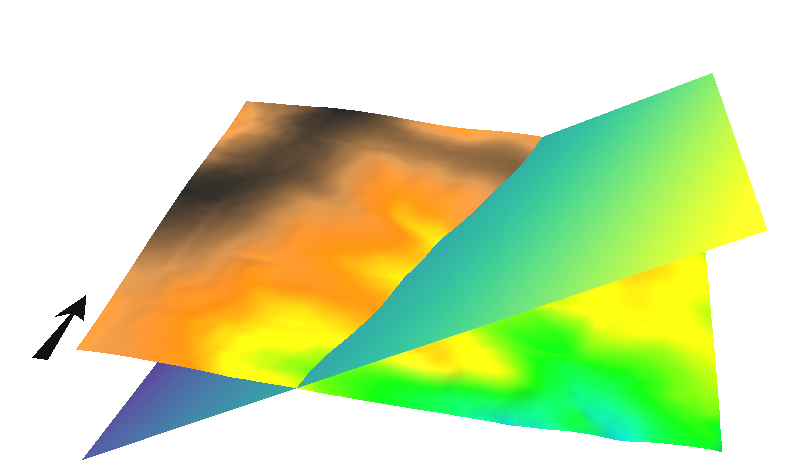
Figure: Tilted plane shown in NVIZ along with elevation map
AUTHORS
Stefan Jäger (1994), University of Heidelberg during a stay at USGSUpdated to GRASS 5.7 by Michael Barton, Arizona State University
Full rewrite for GRASS 7 by Glynn Clements
SOURCE CODE
Available at: r.plane source code (history)
Latest change: Thursday Feb 03 11:10:06 2022 in commit: 547ff44e6aecfb4c9cbf6a4717fc14e521bec0be
Note: This document is for an older version of GRASS GIS that will be discontinued soon. You should upgrade, and read the current manual page.
Main index | Raster index | Topics index | Keywords index | Graphical index | Full index
© 2003-2023 GRASS Development Team, GRASS GIS 8.2.2dev Reference Manual