Note: This document is for an older version of GRASS GIS that has been discontinued. You should upgrade, and read the current manual page.

NAME
r.param.scale - Extracts terrain parameters from a DEM.Uses a multi-scale approach by taking fitting quadratic parameters to any size window (via least squares).
KEYWORDS
raster, geomorphology, terrain, elevation, landformSYNOPSIS
r.param.scale
r.param.scale --helpr.param.scale [-c] input=name output=name [slope_tolerance=float] [curvature_tolerance=float] [size=integer] [method=string] [exponent=float] [zscale=float] [--overwrite] [--help] [--verbose] [--quiet] [--ui]
Flags:
- -c
- Constrain model through central window cell
- --overwrite
- Allow output files to overwrite existing files
- --help
- Print usage summary
- --verbose
- Verbose module output
- --quiet
- Quiet module output
- --ui
- Force launching GUI dialog
Parameters:
- input=name [required]
- Name of input raster map
- output=name [required]
- Name for output raster map containing morphometric parameter
- slope_tolerance=float
- Slope tolerance that defines a 'flat' surface (degrees)
- Default: 1.0
- curvature_tolerance=float
- Curvature tolerance that defines 'planar' surface
- Default: 0.0001
- size=integer
- Size of processing window (odd number only)
- Options: 3-499
- Default: 3
- method=string
- Morphometric parameter in 'size' window to calculate
- Options: elev, slope, aspect, profc, planc, longc, crosc, minic, maxic, feature
- Default: elev
- exponent=float
- Exponent for distance weighting (0.0-4.0)
- Default: 0.0
- zscale=float
- Vertical scaling factor
- Default: 1.0
Table of contents
DESCRIPTION
r.param.scale extracts terrain parameters from a digital elevation model. Uses a multi-scale approach by fitting a bivariate quadratic polynomial to a given window size using least squares.The module calculates the following parameters (terminology is from Wood, 1996 with related terminology used in other GRASS modules listed in brackets):
- elev: Generalised elevation value (for resampling purposes at different scale)
- slope: Magnitude of maximum gradient (steepest slope angle)
- aspect: Direction of maximum gradient (steepest slope direction=flow direction)
- profc: profile curvature (curvature intersecting with the plane defined by Z axis and maximum gradient direction). Positive values describe convex profile curvature, negative values concave profile curvature.
- planc: plan curvature (horizontal curvature, intersecting with the XY plane)
- longc: longitudinal curvature (profile curvature intersecting with the plane defined by the surface normal and maximum gradient direction)
- crosc: cross-sectional curvature (tangential curvature intersecting with the plane defined by the surface normal and a tangent to the contour - perpendicular to maximum gradient direction)
- maxic: maximum curvature (can be in any direction)
- minic: minimum curvature (in direction perpendicular to the direction of of maximum curvature)
- feature: Morphometric features: peaks, ridges, passes, channels, pits and planes
NOTES
In r.param.scale the direction of maximum gradient (considered downslope) is stored as (West is 0 degree, East is +/- 180 degree):- 0..+180 degree from West to North to East
- 0..-180 degree from West to South to East
EXAMPLE
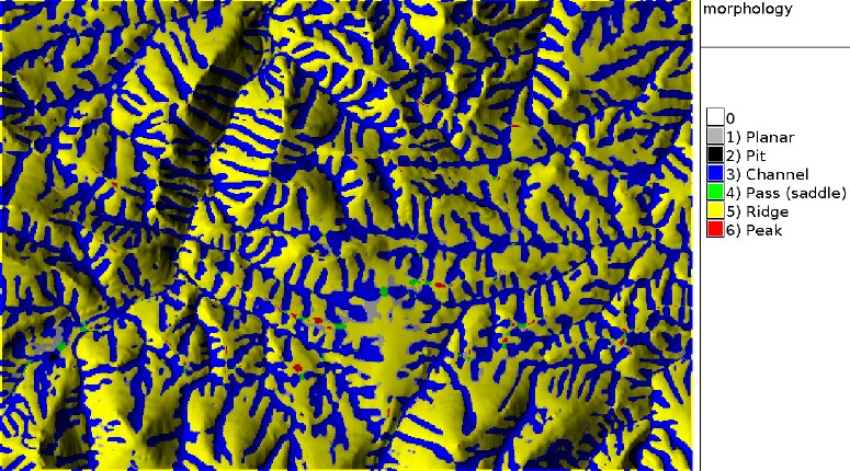
The next commands will create a geomorphological map of the Spearfish sample dataset region:g.region raster=elevation.10m -p r.param.scale in=elevation.10m output=morphology method=feature size=9
TODO
Fix bug when `constrain through central cell' option selected. Create color tables for all output files (presently only on features).REFERENCES
- Wood, J. (1996): The Geomorphological characterisation of
Digital Elevation Models. Diss., Department of Geography, University
of Leicester, U.K
online at: http://hdl.handle.net/2381/34503 - Java Code in LandSerf that implements the same procedure
SEE ALSO
r.geomorphon, r.slope.aspectAUTHORS
Jo Wood - ASSIST's homeUpdate to FP 3/2002: L. Potrich, M. Neteler, S. Menegon (ITC-irst)
SOURCE CODE
Available at: r.param.scale source code (history)
Latest change: Saturday Mar 18 23:15:29 2023 in commit: 0fbe28fa58870681d8852e2787cfac330cf9a9b7
Main index | Raster index | Topics index | Keywords index | Graphical index | Full index
© 2003-2024 GRASS Development Team, GRASS GIS 8.3.3dev Reference Manual
