Note: This document is for an older version of GRASS GIS that has been discontinued. You should upgrade, and read the current manual page.
NAME
v.label.sa - Create optimally placed labels for vector map(s)KEYWORDS
vector, paint labelsSYNOPSIS
v.label.sa
v.label.sa --helpv.label.sa map=name [type=string[,string,...]] [layer=string] column=string labels=name font=string [size=float] [isize=float] [charset=string] [color=string] [hcolor=string] [hwidth=float] [background=string] [opaque=yes|no] [border=string] [width=float] [--help] [--verbose] [--quiet] [--ui]
Flags:
- --help
- Print usage summary
- --verbose
- Verbose module output
- --quiet
- Quiet module output
- --ui
- Force launching GUI dialog
Parameters:
- map=name [required]
- Name of vector map
- Or data source for direct OGR access
- type=string[,string,...]
- Input feature type
- Options: point, line, area
- Default: point,line,area
- layer=string
- Layer number or name
- Vector features can have category values in different layers. This number determines which layer to use. When used with direct OGR access this is the layer name.
- Default: 1
- column=string [required]
- Name of attribute column to be used for labels
- labels=name [required]
- Name for new paint-label file
- font=string [required]
- Name of TrueType font (as listed in the fontcap)
- size=float
- Label size (in map-units)
- Default: 100
- isize=float
- Icon size of point features (in map-units)
- Default: 10
- charset=string
- Character encoding (default: UTF-8)
- Default: UTF-8
- color=string
- Text color
- Options: aqua, black, blue, brown, cyan, gray, green, grey, indigo, magenta, orange, purple, red, violet, white, yellow
- Default: black
- hcolor=string
- Highlight color for text
- Options: none, aqua, black, blue, brown, cyan, gray, green, grey, indigo, magenta, orange, purple, red, violet, white, yellow
- Default: none
- hwidth=float
- Width of highlight coloring
- Default: 0
- background=string
- Background color
- Options: none, aqua, black, blue, brown, cyan, gray, green, grey, indigo, magenta, orange, purple, red, violet, white, yellow
- Default: none
- opaque=yes|no
- Opaque to vector (only relevant if background color is selected)
- Options: yes, no
- Default: yes
- border=string
- Border color
- Options: none, aqua, black, blue, brown, cyan, gray, green, grey, indigo, magenta, orange, purple, red, violet, white, yellow
- Default: none
- width=float
- Border width (only for ps.map output)
- Default: 0
Table of contents
DESCRIPTION
v.label.sa makes a label-file from a GRASS vector map with labels created from attributes in the attached table. The labels are placed in as optimal place as possible. The label file has the same syntax as the one created by v.labelEXAMPLE
North Carolina example:
# get font names:
d.font -L

v.label.sa roadsmajor labels=roads_labels column=ROAD_NAME color=red \
           background=white size=250 font=Vera

# set region:
g.region raster=lsat7_2002_10 -p

# display:
d.rgb b=lsat7_2002_10 g=lsat7_2002_20 r=lsat7_2002_30
d.vect roadsmajor col=yellow
d.labels roads_labels
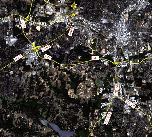
Road labeling with v.label.sa (Raleigh, North Carolina, USA, area)
REFERENCES
Edmondson, Christensen, Marks and Shieber: A General Cartographic Labeling Algorithm, Cartographica, Vol. 33, No. 4, Winter 1996, pp. 13-23 The algorithm works by the principle of Simulated Annealing.SEE ALSO
d.labeld.labels
ps.map Wikipedia article on simulated annealing
AUTHOR
Wolf BergenheimSOURCE CODE
Available at: v.label.sa source code (history)
Latest change: Wednesday Mar 08 22:55:13 2023 in commit: 22b69f88e539740227f4417a47e4b81447a3ab67
Main index | Vector index | Topics index | Keywords index | Graphical index | Full index
© 2003-2024 GRASS Development Team, GRASS GIS 8.3.3dev Reference Manual