g.gui.datacatalog
Tool for browsing, modifying and managing GRASS maps.
g.gui.datacatalog [--verbose] [--quiet] [--qq] [--ui]
Example:
g.gui.datacatalog
grass.tools.Tools.g_gui_datacatalog( verbose=None, quiet=None, superquiet=None)
Example:
tools = Tools()
tools.g_gui_datacatalog()
This grass.tools API is experimental in version 8.5 and expected to be stable in version 8.6.
grass.script.run_command("g.gui.datacatalog", verbose=None, quiet=None, superquiet=None)
Example:
gs.run_command("g.gui.datacatalog")
Parameters
--help
Print usage summary
--verbose
Verbose module output
--quiet
Quiet module output
--qq
Very quiet module output
--ui
Force launching GUI dialog
verbose : bool, optional
Verbose module output
Default: None
quiet : bool, optional
Quiet module output
Default: None
superquiet : bool, optional
Very quiet module output
Default: None
Returns:
result : grass.tools.support.ToolResult | None
If the tool produces text as standard output, a ToolResult object will be returned. Otherwise, None will be returned.
Raises:
grass.tools.ToolError: When the tool ended with an error.
verbose : bool, optional
Verbose module output
Default: None
quiet : bool, optional
Quiet module output
Default: None
superquiet : bool, optional
Very quiet module output
Default: None
DESCRIPTION
The Data Catalog is a wxGUI component for browsing, modifying and managing GRASS maps.
Data Catalog allows you to:
- browse GRASS projects and mapsets in the current GIS directory
- browse GRASS 2D/3D raster and vector maps
- rename, copy, move and delete GRASS maps including reprojection between different projects
- set labels for a GRASS database (directory with GRASS projects) with long paths for easier identification
- drag and drop maps for copying and moving
- searching and filtering maps using regular expressions
- display map in current project
- show metadata of maps
Note that projects are called locations at some places and in old documentation.
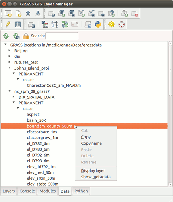
Figure: Data Catalog integrated in wxGUI.
NOTES
Some operations (copying, renaming, deleting) are by default enabled only within the current mapset. To allow changing data outside of your current mapset, you need to press Unlock button in Data Catalog toolbar.
WARNING
When renaming, copying or deleting maps outside of Data Catalog, you need to reload the current mapset or entire database, because it is currently not synchronized.
SEE ALSO
g.copy, g.rename, g.remove, g.list
AUTHORS
Anna Petrasova, NCSU GeoForAll Laboratory
Tereza Fiedlerova, OSGeoREL, Czech Technical University in Prague, Czech
Republic
SOURCE CODE
Available at: g.gui.datacatalog source code
(history)
Latest change: Saturday Jun 13 11:50:54 2026 in commit 6106e16