r.fill.dir
Filters and generates a depressionless elevation map and a flow direction map from a given elevation raster map.
r.fill.dir [-f] input=name output=name direction=name [areas=name] [format=string] [--overwrite] [--verbose] [--quiet] [--qq] [--ui]
Example:
r.fill.dir input=name output=name direction=name
grass.tools.Tools.r_fill_dir(input, output, direction, areas=None, format="grass", flags=None, overwrite=None, verbose=None, quiet=None, superquiet=None)
Example:
tools = Tools()
tools.r_fill_dir(input="name", output="name", direction="name")
This grass.tools API is experimental in version 8.5 and expected to be stable in version 8.6.
grass.script.run_command("r.fill.dir", input, output, direction, areas=None, format="grass", flags=None, overwrite=None, verbose=None, quiet=None, superquiet=None)
Example:
gs.run_command("r.fill.dir", input="name", output="name", direction="name")
Parameters
input=name [required]
Name of input elevation raster map
output=name [required]
Name for output depressionless elevation raster map
direction=name [required]
Name for output flow direction map for depressionless elevation raster map
areas=name
Name for output raster map of problem areas
format=string
Aspect direction format
Allowed values: agnps, answers, grass
Default: grass
-f
Find unresolved areas only
--overwrite
Allow output files to overwrite existing files
--help
Print usage summary
--verbose
Verbose module output
--quiet
Quiet module output
--qq
Very quiet module output
--ui
Force launching GUI dialog
input : str | np.ndarray, required
Name of input elevation raster map
Used as: input, raster, name
output : str | type(np.ndarray) | type(np.array) | type(gs.array.array), required
Name for output depressionless elevation raster map
Used as: output, raster, name
direction : str | type(np.ndarray) | type(np.array) | type(gs.array.array), required
Name for output flow direction map for depressionless elevation raster map
Used as: output, raster, name
areas : str | type(np.ndarray) | type(np.array) | type(gs.array.array), optional
Name for output raster map of problem areas
Used as: output, raster, name
format : str, optional
Aspect direction format
Allowed values: agnps, answers, grass
Default: grass
flags : str, optional
Allowed values: f
f
Find unresolved areas only
overwrite : bool, optional
Allow output files to overwrite existing files
Default: None
verbose : bool, optional
Verbose module output
Default: None
quiet : bool, optional
Quiet module output
Default: None
superquiet : bool, optional
Very quiet module output
Default: None
Returns:
result : grass.tools.support.ToolResult | np.ndarray | tuple[np.ndarray] | None
If the tool produces text as standard output, a ToolResult object will be returned. Otherwise, None will be returned. If an array type (e.g., np.ndarray) is used for one of the raster outputs, the result will be an array and will have the shape corresponding to the computational region. If an array type is used for more than one raster output, the result will be a tuple of arrays.
Raises:
grass.tools.ToolError: When the tool ended with an error.
input : str, required
Name of input elevation raster map
Used as: input, raster, name
output : str, required
Name for output depressionless elevation raster map
Used as: output, raster, name
direction : str, required
Name for output flow direction map for depressionless elevation raster map
Used as: output, raster, name
areas : str, optional
Name for output raster map of problem areas
Used as: output, raster, name
format : str, optional
Aspect direction format
Allowed values: agnps, answers, grass
Default: grass
flags : str, optional
Allowed values: f
f
Find unresolved areas only
overwrite : bool, optional
Allow output files to overwrite existing files
Default: None
verbose : bool, optional
Verbose module output
Default: None
quiet : bool, optional
Quiet module output
Default: None
superquiet : bool, optional
Very quiet module output
Default: None
DESCRIPTION
r.fill.dir filters and generates a depressionless elevation map and a flow direction map from a given raster elevation map. The method adopted to filter the elevation map and rectify it is based on the paper titled "Extracting topographic structure from digital elevation model data for geographic information system analysis" by S.K. Jenson and J.O. Domingue (1988).
The procedure takes an elevation layer as input and initially fills all the depressions with one pass across the layer. Next, the flow direction algorithm tries to find a unique direction for each cell. If the watershed program detects areas with pothholes, it delineates this area from the rest of the area and once again the depressions are filled using the neighborhood technique used by the flow direction routine. The final output will be a depressionless elevation layer and a unique flow direction layer.
This (D8) flow algorithm performs as follows: At each raster cell the code determines the slope to each of the 8 surrounding cells and assigns the flow direction to the highest slope out of the cell. If there is more than one equal, non-zero slope then the code picks one direction based on preferences that are hard-coded into the program. If the highest slope is flat and in more than one direction then the code first tries to select an alternative based on flow directions in the adjacent cells. r.fill.dir iterates that process, effectively propagating flow directions from areas where the directions are known into the area where the flow direction cannot otherwise be resolved.
The format parameter is the type of format at which the user wishes to create the flow direction map. The flow direction map can be encoded in GRASS aspect format, ANSWERS (Beasley et.al, 1982), or AGNPS (Young et.al, 1985) format, so that it can be readily used as input to other GRASS modules or the aforementioned hydrological models. The grass format gives the same category values as r.slope.aspect gives for aspect, i.e. angles in degrees counter-clockwise from east in 45 degree increments. The agnps format gives category values from 1-8, with 1 facing north and increasing values in the clockwise direction. The answers format gives category values from 0-360 degrees, with 0 (represented as 360) facing east and values increasing in the counter-clockwise direction at 45 degree increments. In all cases, NULL (no data) values are used for cells where direction cannot be determined.
In case of local problems, those unfilled areas can be stored optionally. Each unfilled area in this maps is numbered. The -f flag instructs the program to fill single-cell pits but otherwise to just find the undrained areas and exit. With the -f flag set the program writes an elevation map with just single-cell pits filled, a direction map with unresolved problems and a map of the undrained areas that were found but not filled. This option was included because filling DEMs was often not the best way to solve a drainage problem. These options let the user get a partially-fixed elevation map, identify the remaining problems and fix the problems appropriately.
In some cases it may be necessary to run r.fill.dir repeatedly (using output from one run as input to the next run) before all of problem areas are filled.
The resulting depressionless elevation raster map can further be processed to derive slopes and other attributes required by other hydrological models.
As any GRASS module, r.fill.dir respects the computational region settings. Thus, the module can be used to generate a flow direction map for any sub-area within the full raster map layer. Also, r.fill.dir will take into account an active raster mask.
NOTES
- The r.fill.dir module can be used not only to fill depression, but also to detect water bodies or potential water bodies based on the nature of the terrain and the digital elevation model used.
- Not all depressions are errors in digital elevation models. In fact, many are wetlands and as Jenkins and McCauley (2006) note careless use of depression filling may lead to unintended consequences such as loss of wetlands.
- Although many hydrological algorithms require depression filling, advanced algorithms such as those implemented in r.watershed and r.sim.water do not require depressionless digital elevation model to work.
- The flow direction map can be visualized with d.rast.arrow.
EXAMPLES
Generic example: create a depressionless (sinkless) elevation map ansi.fill.elev and a flow direction map ansi.asp for the type "grass":
r.fill.dir input=ansi.elev output=ansi.fill.elev direction=ansi.asp
North Carolina sample dataset example: The LiDAR derived 1m elevation map is sink-filled. The outcome are a depressionless elevation map, the flow direction map and an error map.
# set computational region to elevation map
g.region raster=elev_lid792_1m -p
# generate depressionless DEM and related maps
r.fill.dir input=elev_lid792_1m output=elev_lid792_1m_filled \
           direction=elev_lid792_1m_dir areas=elev_lid792_1m_error

# generate elevation map of pixelwise differences to see obtained terrain alterations
r.mapcalc "elev_lid792_1m_diff = elev_lid792_1m_filled - elev_lid792_1m"
r.colors elev_lid792_1m_diff color=differences

# assess univariate statistics of differences
r.univar -e elev_lid792_1m_diff

# vectorize filled areas (here all fills are of positive value, see r.univar output)
r.mapcalc "elev_lid792_1m_fill_area = if(elev_lid792_1m_diff > 0.0, 1, null() )"
r.to.vect input=elev_lid792_1m_fill_area output=elev_lid792_1m_fill_area type=area

# generate shaded terrain for better visibility of results
r.relief input=elev_lid792_1m_filled output=elev_lid792_1m_filled_shade

d.mon wx0
d.shade shade=elev_lid792_1m_filled_shade color=elev_lid792_1m_filled
d.vect elev_lid792_1m_fill_area type=boundary color=red
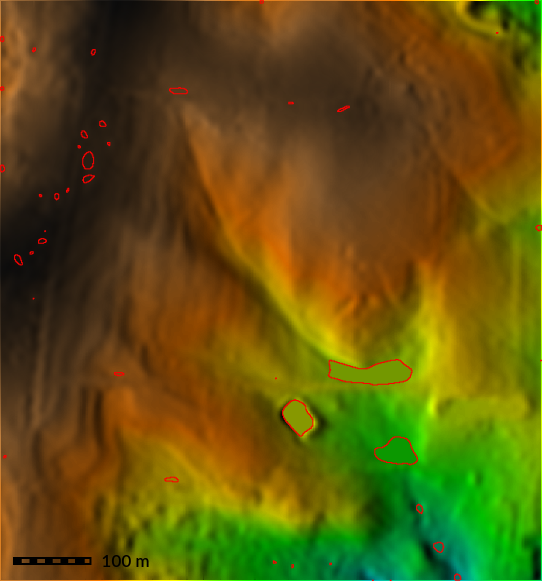
Figure: Sink-filled DEM (shown as shaded terrain) with areas of filling
shown as vector polygons
REFERENCES
- Beasley, D.B. and L.F. Huggins. 1982. ANSWERS (areal nonpoint source watershed environmental response simulation): User's manual. U.S. EPA-905/9-82-001, Chicago, IL, 54 p.
- Jenkins, D. G., and McCauley, L. A. 2006. GIS, SINKS, FILL, and disappearing wetlands: unintended consequences in algorithm development and use. In Proceedings of the 2006 ACM symposium on applied computing (pp. 277-282).
- Jenson, S.K., and J.O. Domingue. 1988. Extracting topographic structure from digital elevation model data for geographic information system analysis. Photogram. Engr. and Remote Sens. 54: 1593-1600.
- Young, R.A., C.A. Onstad, D.D. Bosch and W.P. Anderson. 1985. Agricultural nonpoint surface pollution models (AGNPS) I and II model documentation. St. Paul: Minn. Pollution control Agency and Washington D.C., USDA-Agricultural Research Service.
SEE ALSO
d.rast.arrow, d.shade, g.region, r.fillnulls, r.relief, r.slope.aspect
AUTHORS
Fortran version: Raghavan Srinivasan, Agricultural Engineering
Department, Purdue University
Rewrite to C with enhancements: Roger S. Miller
SOURCE CODE
Available at: r.fill.dir source code
(history)
Latest change: Friday Apr 17 01:04:26 2026 in commit 5a31d54