r.geomorphon
Calculates geomorphons (terrain forms) and associated geometry using machine vision approach.
r.geomorphon [-me] elevation=name [forms=name] [ternary=name] [positive=name] [negative=name] [intensity=name] [exposition=name] [range=name] [variance=name] [elongation=name] [azimuth=name] [extend=name] [width=name] search=integer skip=integer flat=float dist=float [comparison=string] [coordinates=east,north] [profiledata=name] [profileformat=string] [--overwrite] [--verbose] [--quiet] [--qq] [--ui]
Example:
r.geomorphon elevation=name search=3 skip=0 flat=1 dist=0
grass.tools.Tools.r_geomorphon(elevation, forms=None, ternary=None, positive=None, negative=None, intensity=None, exposition=None, range=None, variance=None, elongation=None, azimuth=None, extend=None, width=None, search=3, skip=0, flat=1, dist=0, comparison="anglev1", coordinates=None, profiledata=None, profileformat=None, flags=None, overwrite=None, verbose=None, quiet=None, superquiet=None)
Example:
tools = Tools()
tools.r_geomorphon(elevation="name", search=3, skip=0, flat=1, dist=0)
This grass.tools API is experimental in version 8.5 and expected to be stable in version 8.6.
grass.script.run_command("r.geomorphon", elevation, forms=None, ternary=None, positive=None, negative=None, intensity=None, exposition=None, range=None, variance=None, elongation=None, azimuth=None, extend=None, width=None, search=3, skip=0, flat=1, dist=0, comparison="anglev1", coordinates=None, profiledata=None, profileformat=None, flags=None, overwrite=None, verbose=None, quiet=None, superquiet=None)
Example:
gs.run_command("r.geomorphon", elevation="name", search=3, skip=0, flat=1, dist=0)
Parameters
elevation=name [required]
Name of input elevation raster map
forms=name
Most common geomorphic forms
ternary=name
Code of ternary patterns
positive=name
Code of binary positive patterns
negative=name
Code of binary negative patterns
intensity=name
Rasters containing mean relative elevation of the form
exposition=name
Rasters containing maximum difference between extend and central cell
range=name
Rasters containing difference between max and min elevation of the form extend
variance=name
Rasters containing variance of form boundary
elongation=name
Rasters containing local elongation
azimuth=name
Rasters containing local azimuth of the elongation
extend=name
Rasters containing local extend (area) of the form
width=name
Rasters containing local width of the form
search=integer [required]
Outer search radius
Default: 3
skip=integer [required]
Inner search radius
Default: 0
flat=float [required]
Flatness threshold (degrees)
Default: 1
dist=float [required]
Flatness distance, zero for none
Default: 0
comparison=string
Comparison mode for zenith/nadir line-of-sight search
Allowed values: anglev1, anglev2, anglev2_distance
Default: anglev1
coordinates=east,north
Coordinates to profile
profiledata=name
Profile output file name ("-" for stdout)
profileformat=string
Profile output format
Allowed values: json, yaml, xml
-m
Use meters to define search units (default is cells)
-e
Use extended form correction
--overwrite
Allow output files to overwrite existing files
--help
Print usage summary
--verbose
Verbose module output
--quiet
Quiet module output
--qq
Very quiet module output
--ui
Force launching GUI dialog
elevation : str | np.ndarray, required
Name of input elevation raster map
Used as: input, raster, name
forms : str | type(np.ndarray) | type(np.array) | type(gs.array.array), optional
Most common geomorphic forms
Used as: output, raster, name
ternary : str | type(np.ndarray) | type(np.array) | type(gs.array.array), optional
Code of ternary patterns
Used as: output, raster, name
positive : str | type(np.ndarray) | type(np.array) | type(gs.array.array), optional
Code of binary positive patterns
Used as: output, raster, name
negative : str | type(np.ndarray) | type(np.array) | type(gs.array.array), optional
Code of binary negative patterns
Used as: output, raster, name
intensity : str | type(np.ndarray) | type(np.array) | type(gs.array.array), optional
Rasters containing mean relative elevation of the form
Used as: output, raster, name
exposition : str | type(np.ndarray) | type(np.array) | type(gs.array.array), optional
Rasters containing maximum difference between extend and central cell
Used as: output, raster, name
range : str | type(np.ndarray) | type(np.array) | type(gs.array.array), optional
Rasters containing difference between max and min elevation of the form extend
Used as: output, raster, name
variance : str | type(np.ndarray) | type(np.array) | type(gs.array.array), optional
Rasters containing variance of form boundary
Used as: output, raster, name
elongation : str | type(np.ndarray) | type(np.array) | type(gs.array.array), optional
Rasters containing local elongation
Used as: output, raster, name
azimuth : str | type(np.ndarray) | type(np.array) | type(gs.array.array), optional
Rasters containing local azimuth of the elongation
Used as: output, raster, name
extend : str | type(np.ndarray) | type(np.array) | type(gs.array.array), optional
Rasters containing local extend (area) of the form
Used as: output, raster, name
width : str | type(np.ndarray) | type(np.array) | type(gs.array.array), optional
Rasters containing local width of the form
Used as: output, raster, name
search : int, required
Outer search radius
Default: 3
skip : int, required
Inner search radius
Default: 0
flat : float, required
Flatness threshold (degrees)
Default: 1
dist : float, required
Flatness distance, zero for none
Default: 0
comparison : str, optional
Comparison mode for zenith/nadir line-of-sight search
Allowed values: anglev1, anglev2, anglev2_distance
Default: anglev1
coordinates : tuple[float, float] | list[float] | str, optional
Coordinates to profile
Used as: input, coords, east,north
profiledata : str, optional
Profile output file name ("-" for stdout)
Used as: output, file, name
profileformat : str, optional
Profile output format
Allowed values: json, yaml, xml
flags : str, optional
Allowed values: m, e
m
Use meters to define search units (default is cells)
e
Use extended form correction
overwrite : bool, optional
Allow output files to overwrite existing files
Default: None
verbose : bool, optional
Verbose module output
Default: None
quiet : bool, optional
Quiet module output
Default: None
superquiet : bool, optional
Very quiet module output
Default: None
Returns:
result : grass.tools.support.ToolResult | np.ndarray | tuple[np.ndarray] | None
If the tool produces text as standard output, a ToolResult object will be returned. Otherwise, None will be returned. If an array type (e.g., np.ndarray) is used for one of the raster outputs, the result will be an array and will have the shape corresponding to the computational region. If an array type is used for more than one raster output, the result will be a tuple of arrays.
Raises:
grass.tools.ToolError: When the tool ended with an error.
elevation : str, required
Name of input elevation raster map
Used as: input, raster, name
forms : str, optional
Most common geomorphic forms
Used as: output, raster, name
ternary : str, optional
Code of ternary patterns
Used as: output, raster, name
positive : str, optional
Code of binary positive patterns
Used as: output, raster, name
negative : str, optional
Code of binary negative patterns
Used as: output, raster, name
intensity : str, optional
Rasters containing mean relative elevation of the form
Used as: output, raster, name
exposition : str, optional
Rasters containing maximum difference between extend and central cell
Used as: output, raster, name
range : str, optional
Rasters containing difference between max and min elevation of the form extend
Used as: output, raster, name
variance : str, optional
Rasters containing variance of form boundary
Used as: output, raster, name
elongation : str, optional
Rasters containing local elongation
Used as: output, raster, name
azimuth : str, optional
Rasters containing local azimuth of the elongation
Used as: output, raster, name
extend : str, optional
Rasters containing local extend (area) of the form
Used as: output, raster, name
width : str, optional
Rasters containing local width of the form
Used as: output, raster, name
search : int, required
Outer search radius
Default: 3
skip : int, required
Inner search radius
Default: 0
flat : float, required
Flatness threshold (degrees)
Default: 1
dist : float, required
Flatness distance, zero for none
Default: 0
comparison : str, optional
Comparison mode for zenith/nadir line-of-sight search
Allowed values: anglev1, anglev2, anglev2_distance
Default: anglev1
coordinates : tuple[float, float] | list[float] | str, optional
Coordinates to profile
Used as: input, coords, east,north
profiledata : str, optional
Profile output file name ("-" for stdout)
Used as: output, file, name
profileformat : str, optional
Profile output format
Allowed values: json, yaml, xml
flags : str, optional
Allowed values: m, e
m
Use meters to define search units (default is cells)
e
Use extended form correction
overwrite : bool, optional
Allow output files to overwrite existing files
Default: None
verbose : bool, optional
Verbose module output
Default: None
quiet : bool, optional
Quiet module output
Default: None
superquiet : bool, optional
Very quiet module output
Default: None
DESCRIPTION
r.geomorphon calculates terrain forms using machine-vison technique called geomorphons.
What is geomorphon
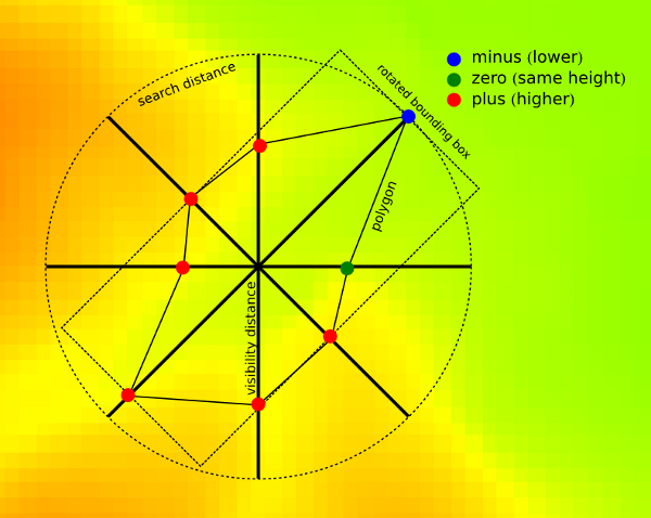
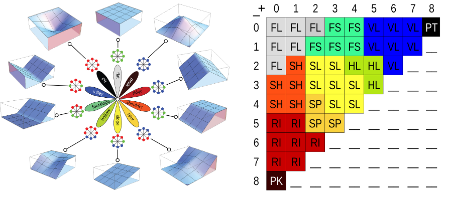
Geomorphon is a new concept of presentation and analysis of terrain forms. This concept utilises 8-tuple pattern of the visibility neighbourhood and breaks well known limitation of standard calculus approach where all terrain forms cannot be detected in a single window size. The pattern arises from a comparison of a focus pixel with its eight neighbors starting from the one located to the east and continuing counterclockwise producing ternary operator. For example, a tuple {+,-,-,-,0,+,+,+} describes one possible pattern of relative measures {higher, lower, lower, lower, equal, higher, higher, higher} for pixels surrounding the focus pixel. It is important to stress that the visibility neighbors are not necessarily an immediate neighbors of the focus pixel in the grid, but the pixels determined from the line-of-sight principle along the eight principal directions. This principle relates surface relief and horizontal distance by means of so-called zenith and nadir angles along the eight principal compass directions. The ternary operator converts the information contained in all the pairs of zenith and nadir angles into the ternary pattern (8-tuple). The result depends on the values of two parameters: search radius (L) and relief threshold (d). The search radius is the maximum allowable distance for calculation of zenith and nadir angles. The relief threshold is a minimum value of difference between LOSs angle (zenith and nadir) that is considered significantly different from the horizon. Two lines-of-sight are necessary due to zenith LOS only, does not detect positive forms correctly.
There are 3**8 = 6561 possible ternary patterns (8-tuples). By removing all patterns that are the result of either rotation or reflection of other patterns, a set of 498 patterns remains, referred to as geomorphons. This is a comprehensive and exhaustive set of idealized landforms that are independent of the size, relief, and orientation of the actual landform.
Form recognition depends on two free parameters: Search radius and flatness threshold. Using larger values of L and is tantamount to terrain classification from a higher and wider perspective, whereas using smaller values of L and is tantamount to terrain classification from a local point of view. A character of the map depends on the value of L. Using small value of L results in the map that correctly identifies landforms if their size is smaller than L; landforms having larger sizes are broken down into components. Using larger values of L allows simultaneous identification of landforms on variety of sizes in expense of recognition smaller, second-order forms. There are two additional parameters: skip radius used to eliminate impact of small irregularities. On the contrary flatness distance eliminates the impact of very high distance (in meters) of search radius which may not detect elevation difference if this is at very far distance. Important especially with low resolution DEMS.
OPTIONS
-m
All distance parameters (search, skip, flat distances) are supplied as
meters instead of cells (default). To avoid situation when supplied
distances is smaller than one cell program first check if supplied
distance is longer than one cell in both NS and WE directions. For
LatLong projection only NS distance checked, because in latitude angular
unit comprise always bigger or equal distance than longitude one. If
distance is supplied in cells, For all projections is recalculated into
meters according formula:
number_of_cells*resolution_along_NS_direction. It is important if
geomorphons are calculated for large areas in LatLong projection.
elevation
Digital elevation model. Data can be of any type and any projection.
During calculation DEM is stored as floating point raster.
search
Determines length on the geodesic distances in all eight directions
where line-of-sight is calculated. To speed up calculation is determines
only these cells which centers falls into the distance.
skip
Determines length on the geodesic distances at the beginning of
calculation all eight directions where line-of-sight is yet calculated.
To speed up calculation this distance is always recalculated into number
of cell which are skipped at the beginning of every line-of-sight and is
equal in all direction. This parameter eliminates forms of very small
extend, smaller than skip parameter.
flat
The difference (in degrees) between zenith and nadir line-of-sight which
indicate flat direction. If higher threshold produce more flat maps. If
resolution of the map is low (more than 1 km per cell) threshold should
be very small (much smaller than 1 degree) because on such distance 1
degree of difference means several meters of high difference.
dist
Flat distance. This is additional parameter defining the distance above
which the threshold starts to decrease to avoid problems with
pseudo-flat line-of-sights if real elevation difference appears on the
distance where its value is higher (TO BE CORRECTED).
comparison
Comparison mode for zenith/nadir line-of-sight search. "anglev1" is the
original r.geomorphon comparison mode. "anglev2" is an improved mode,
which better handles angle thresholds and zenith/nadir angles that are
exactly equal. "anglev2_distance" in addition to that takes the
zenith/nadir distances into account when the angles are exactly equal.
forms
Returns geomorphic map with 10 most popular terrestrial forms. Legend
for forms, its definition by the number of + and - and its idealized
visualisation are presented at the image.
Forms represented by geomorphons
ternary
returns code of one of 498 unique ternary patterns for every cell. The
code is a decimal representation of 8-tuple minimalised patterns written
in ternary system. Full list of patterns is available in source code
directory as patterns.txt. This map can be used to create alternative
form classification using supervised approach.
positive and negative
returns codes binary patterns for zenith (positive) and nadir (negative)
line of sights. The code is a decimal representation of 8-tuple
minimalised patterns written in binary system. Full list of patterns is
available in source code directory as patterns.txt.
coordinates
The central point of a single geomorphon to profile. The central point
must be within the computational region, which should be large enough to
accommodate the search radius. Setting the region larger than that will
not produce more accurate data, but in the current implementation will
slow the computation down. For the best results remember to align the
region to the raster cells. Profiling is mutually exclusive with any
raster outputs, but other parameters and flags (such as elevation,
search, comparison, -m and -e) work as usual.
profiledata
The output file name for the complete profile data, "-" means to write
to the standard output. The data is in a machine-readable format and it
includes assorted values describing the computation context and
parameters, as well as its intermediate and final results.
profileformat
Format of the profile data: "json", "yaml" or "xml".
NOTE: parameters below are experimental. The usefulness of these parameters are currently under investigation.
intensity
returns average difference between central cell of geomorphon and eight
cells in visibility neighbourhood. This parameter shows local (as is
visible) exposition/abasement of the form in the terrain.
range
returns difference between minimum and maximum values of visibility
neighbourhood.
variance
returns variance (difference between particular values and mean value)
of visibility neighbourhood.
extend
returns area of the polygon created by the 8 points where line-of-sight
cuts the terrain (see image in description section).
azimuth
returns orientation of the polygon constituting geomorphon. This
orientation is currently calculated as a orientation of least square fit
line to the eight verticles of this polygon.
elongation
returns proportion between sides of the bounding box rectangle
calculated for geomorphon rotated to fit least square line.
width
returns length of the shorter side of the bounding box rectangle
calculated for geomorphon rotated to fit least square line.
NOTES
From computational point of view there are no limitations of input DEM and free parameters used in calculation. However, in practice there are some issues on DEM resolution and search radius. Low resolution DEM especially above 1 km per cell requires smaller than default flatness threshold. On the other hand, only forms with high local elevation difference will be detected correctly. It results from fact that on very high distance (of order of kilometers or higher) even relatively high elevation difference will be recognized as flat. For example at the distance of 8 km (8 cells with 1 km resolution DEM) an relative elevation difference of at least 136 m is required to be noticed as non-flat. Flatness distance threshold may be helpful to avoid this problem.
EXAMPLES
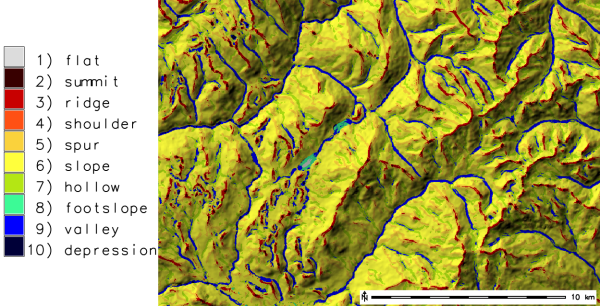
Geomorphon calculation: extraction of terrestrial landforms
Geomorphon calculation example using the EU DEM 25m:
g.region raster=eu_dem_25m -p
r.geomorphon elevation=eu_dem_25m forms=eu_dem_25m_geomorph

# verify terrestrial landforms found in DEM
r.category eu_dem_25m_geomorph
 1  flat
 2  peak
 3  ridge
 4  shoulder
 5  spur
 6  slope
 7  hollow
 8  footslope
 9  valley
 10 pit
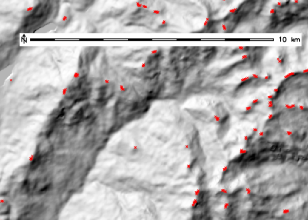
Extraction of peaks
Using the resulting terrestrial landforms map, single landforms can be extracted, e.g. the peaks, and converted into a vector point map:
r.mapcalc expression="eu_dem_25m_peaks = if(eu_dem_25m_geomorph == 2, 1, null())"
r.thin input=eu_dem_25m_peaks output=eu_dem_25m_peaks_thinned
r.to.vect input=eu_dem_25m_peaks_thinned output=eu_dem_25m_peaks type=point
v.info input=eu_dem_25m_peaks
REFERENCES
- Stepinski, T., Jasiewicz, J., 2011, Geomorphons - a new approach to classification of landform, in : Eds: Hengl, T., Evans, I.S., Wilson, J.P., and Gould, M., Proceedings of Geomorphometry 2011, Redlands, 109-112 (PDF)
- Jasiewicz, J., Stepinski, T., 2013, Geomorphons - a pattern recognition approach to classification and mapping of landforms, Geomorphology, vol. 182, 147-156 (DOI: 10.1016/j.geomorph.2012.11.005)
SEE ALSO
AUTHORS
Jarek Jasiewicz, Tomek Stepinski (merit contribution)
SOURCE CODE
Available at: r.geomorphon source code
(history)
Latest change: Tuesday May 19 03:13:35 2026 in commit df7adb5