r.fuzzy.set
Calculate membership value of any raster map according to a user's rules.
r.fuzzy.set input=name output=name points=string [,string,...] [side=string] [boundary=string] [shape=float] [height=float] [--overwrite] [--verbose] [--quiet] [--qq] [--ui]
Example:
r.fuzzy.set input=name output=name points=a,b[,c,d]
grass.tools.Tools.r_fuzzy_set(input, output, points="a,b[,c,d]", side="both", boundary="S-shaped", shape=0., height=1., overwrite=None, verbose=None, quiet=None, superquiet=None)
Example:
tools = Tools()
tools.r_fuzzy_set(input="name", output="name", points="a,b[,c,d]")
This grass.tools API is experimental in version 8.5 and expected to be stable in version 8.6.
grass.script.run_command("r.fuzzy.set", input, output, points="a,b[,c,d]", side="both", boundary="S-shaped", shape=0., height=1., overwrite=None, verbose=None, quiet=None, superquiet=None)
Example:
gs.run_command("r.fuzzy.set", input="name", output="name", points="a,b[,c,d]")
Parameters
input=name [required]
Raster map to be fuzzified
output=name [required]
Membership map
points=string [,string,...] [required]
Inflection points: a,b[,c,d]
Default: a,b[,c,d]
side=string
Fuzzy range
Allowed values: both, left, right
Default: both
boundary=string
Type of fuzzy boundaries
Allowed values: Linear, S-shaped, J-shaped, G-shaped
Default: S-shaped
shape=float
Shape modifier: -1 to 1
Allowed values: -1-1
Default: 0.
height=float
Membership height: 0 to 1
Allowed values: 0-1
Default: 1.
--overwrite
Allow output files to overwrite existing files
--help
Print usage summary
--verbose
Verbose module output
--quiet
Quiet module output
--qq
Very quiet module output
--ui
Force launching GUI dialog
input : str | np.ndarray, required
Raster map to be fuzzified
Used as: input, raster, name
output : str | type(np.ndarray) | type(np.array) | type(gs.array.array), required
Membership map
Used as: output, raster, name
points : str | list[str], required
Inflection points: a,b[,c,d]
Default: a,b[,c,d]
side : str, optional
Fuzzy range
Allowed values: both, left, right
Default: both
boundary : str, optional
Type of fuzzy boundaries
Allowed values: Linear, S-shaped, J-shaped, G-shaped
Default: S-shaped
shape : float, optional
Shape modifier: -1 to 1
Allowed values: -1-1
Default: 0.
height : float, optional
Membership height: 0 to 1
Allowed values: 0-1
Default: 1.
overwrite : bool, optional
Allow output files to overwrite existing files
Default: None
verbose : bool, optional
Verbose module output
Default: None
quiet : bool, optional
Quiet module output
Default: None
superquiet : bool, optional
Very quiet module output
Default: None
Returns:
result : grass.tools.support.ToolResult | np.ndarray | tuple[np.ndarray] | None
If the tool produces text as standard output, a ToolResult object will be returned. Otherwise, None will be returned. If an array type (e.g., np.ndarray) is used for one of the raster outputs, the result will be an array and will have the shape corresponding to the computational region. If an array type is used for more than one raster output, the result will be a tuple of arrays.
Raises:
grass.tools.ToolError: When the tool ended with an error.
input : str, required
Raster map to be fuzzified
Used as: input, raster, name
output : str, required
Membership map
Used as: output, raster, name
points : str | list[str], required
Inflection points: a,b[,c,d]
Default: a,b[,c,d]
side : str, optional
Fuzzy range
Allowed values: both, left, right
Default: both
boundary : str, optional
Type of fuzzy boundaries
Allowed values: Linear, S-shaped, J-shaped, G-shaped
Default: S-shaped
shape : float, optional
Shape modifier: -1 to 1
Allowed values: -1-1
Default: 0.
height : float, optional
Membership height: 0 to 1
Allowed values: 0-1
Default: 1.
overwrite : bool, optional
Allow output files to overwrite existing files
Default: None
verbose : bool, optional
Verbose module output
Default: None
quiet : bool, optional
Quiet module output
Default: None
superquiet : bool, optional
Very quiet module output
Default: None
OPTIONS
-
input
Name of input raster map to be fuzzified. This map may be of any type and may require null values. -
points
A list containing 4 (A,B,C,D) or 2 (A,B) points defining set boundaries as defined in Figure 1. Points do not have to be in map range, but this may lead to only 0 or 1 membership for the whole map. For side parameter "both", range between A and D defines base, and the range between B and C defines the core of the fuzzy set. Between A and B and between C and D are the set's boundaries. If side is "both", points requires 4 points, or else 2 points.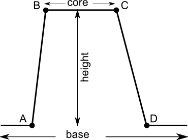
Figure 1: Fuzzy set definition -
side
Option indicates if set is fuzzified of both sides (both), left or right side. See description for details.
OUTPUTS
- output
Map containing membership value of original map. Map is alvays of type FCELLS and contains values from 0 (no membership) to 1 (full membership). Values between 0 and 1 indicate partial membership
FUZZY SET PARAMETERS
-
boundary
Parameter defined the shape of the fuzzy boundary. The default and most popular is S-shaped, linear, J-shaped and G-shaped boundaries are also available. The same boundaries are applied to the both sides. The available options are illustrated in Figure 2.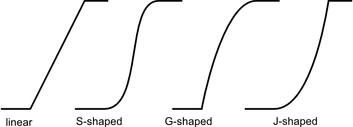
Figure 2: Boundary definition for boundary parameter values "Linear", "S-shaped", "G-shaped", and "J-shaped" -
shape
Optional shape modifier. Range from -1 to 1. The default value is 0 and should not be changed in most of the time. The negative values indicate more dilatant set, the positive values more concentrate set. See NOTES for details.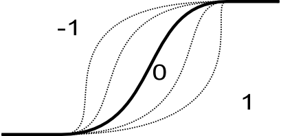
Figure 3: Impact of shape parameter on shape boundary -
height
Optional height modifier. Range from 0 to 1. The default value is 1 and indicates full membership. If height is less than one, the maximum membership is equal to height. See Figure 1: Fuzzy set definition.
DESCRIPTION
Definition of fuzzy set
Fuzzy sets are sets whose elements have degrees of membership. Zadeh (1965) introduced fuzzy sets as an extension of the classical notion of sets. Classical membership of elements in a set are binary terms: an element either belongs or does not belong to the set. Fuzzy set theory use the gradual assessment of the membership of elements in a set. A membership function is valued in the real unit interval [0, 1]. Classical sets are special cases of the membership functions of fuzzy sets, if the latter only takes values 0 or 1. Classical sets are in fuzzy set theory usually called crisp sets. Fuzzy set theory can be used in a wide range of domains in which information is imprecise, including many GIS operations.
NOTES
Calculation of boundary shape
Depending on type of the boundary, different equations are used to determine its shape:
Linear: the membership is calculated according following equation:
value  <=  A -> x = 0
A < value > B -> x = (value-A)/(B-A)
B <= value >= C -> x = 1
C < value > D -> x = (D-value)/(D-C)
value >= D -> x = 0

where x: membership
S-shaped: the membership is calculated according following equation:
sin(x * Pi/2)^m (for positive shape parameter)
1-cos(x * Pi/2)^m (for negative shape parameter)

where x: membership, and
m = 2^exp(2 * |shape|)
For default shape=0, m = 2 (most common parameter for that equation).
G-shaped: the membership is calculated according following equation:
tan(x * Pi/4)^1/m

where x: membership, and
m = 2^exp(-2 * shape) (for negative shape parameter)
m = 2^(1-shape) (for positive shape parameter)
For default shape=0, m = 2 (most common parameter for that equation).
J shaped: it uses following equations:
tan(x * Pi/4)^m

where x: membership, and
m = 2^exp(2 * shape) (for positive shape parameter)
m = 2^(1+shape) (for negative shape parameter)
For default shape=0, m = 2 (most common parameter for that equation).
SEE ALSO
r.fuzzy.logic, r.fuzzy.system, r.mapcalc
REFERENCES
- Jasiewicz, J. (2011). A new GRASS GIS fuzzy inference system for massive data analysis. Computers & Geosciences (37) 1525-1531. DOI https://doi.org/10.1016/j.cageo.2010.09.008
- Zadeh, L.A. (1965). "Fuzzy sets". Information and Control 8 (3): 338–353. https://doi.org/10.1016/S0019-9958(65)90241-X.
- Novák, Vilém (1989). Fuzzy Sets and Their Applications. Bristol: Adam Hilger. ISBN 0-85274-583-4.
- Klir, George J.; Yuan, Bo (1995). Fuzzy sets and fuzzy logic: theory and applications. Upper Saddle River, NJ: Prentice Hall PTR. ISBN 0-13-101171-5.
- Klir, George J.; St Clair, Ute H.; Yuan, Bo (1997). Fuzzy set theory: foundations and applications. Englewood Cliffs, NJ: Prentice Hall. ISBN 0133410587.
- Meyer D, Hornik K (2009a). Generalized and Customizable Sets in R. Journal of Statistical Software, 31(2), 1-27. DOI https://doi.org/10.18637/jss.v031.i02
- Meyer D, Hornik K (2009b). sets: Sets, Generalized Sets, and Customizable Sets. R\~package version\~1.0, URL https://cran.r-project.org/package=sets.
AUTHOR
Jarek Jasiewicz
SOURCE CODE
Available at: r.fuzzy.set source code
(history)
Latest change: Wednesday Mar 11 08:17:30 2026 in commit 2a14bbb