NAME
r.watersheds - Delineates a large number of watersheds using the Memory-Efficient Watershed Delineation (MESHED) OpenMP parallel algorithm by Cho (2025).KEYWORDS
raster, hydrology, watershed delineationSYNOPSIS
Flags:
- -m
- Use less memory
- --overwrite
- Allow output files to overwrite existing files
- --help
- Print usage summary
- --verbose
- Verbose module output
- --quiet
- Quiet module output
- --ui
- Force launching GUI dialog
Parameters:
- direction=name [required]
- Name of input direction raster map
- format=string [required]
- Format of input direction raster map
- Options: auto, degree, 45degree, power2
- Default: auto
- auto: auto-detect direction format
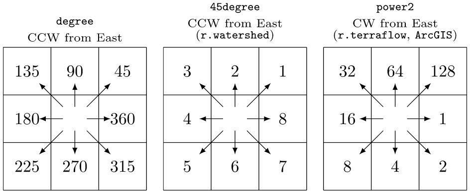
- degree: degrees CCW from East
- 45degree: degrees CCW from East divided by 45 (e.g. r.watershed)
- power2: powers of 2 CW from East (e.g., r.terraflow, ArcGIS)
- outlets=name [required]
- Name of input outlets vector map
- Or data source for direct OGR access
- layer=string
- Layer number or name
- Vector features can have category values in different layers. This number determines which layer to use. When used with direct OGR access this is the layer name.
- Default: 1
- column=name
- Name of attribute column for watershed IDs (using a non-default column is slower)
- Default: cat
- output=name [required]
- Name for output watersheds raster map
Table of contents
DESCRIPTION
r.watersheds delineates a large number of watersheds from a flow direction raster map and an outlets vector map using the Memory-Efficient Watershed Delineation (MESHED) OpenMP parallel algorithm by Cho (2025).NOTES
r.watersheds uses a flow direction raster map and an outlets vector map to delineate a large number of watersheds in parallel using OpenMP.The module recognizes three different formats of flow directions:

For comparisons, using an i7-1370P CPU with 64GB memory and a 30-meter flow direction map for the entire Texas (1.8 billion cells), r.watersheds took 1 minute 27 seconds to delineate the entire state using 60,993 outlet cells draining away (see below how to extract draining cells) while r.stream.basins 5 minutes 28 seconds, both using the category column. However, r.watersheds with a non-category column took 6 minutes 21 seconds because of heavy database queries.
EXAMPLES
These examples use the North Carolina sample dataset.Calculate flow accumulation using r.watershed and delineate all watersheds from draining cells using r.watersheds:
# set computational region
g.region -ap raster=elevation

# calculate drainage directions using r.watershed
r.watershed -s elevation=elevation drainage=drain

# extract draining cells
r.mapcalc ex="dcells=if(\
        (isnull(drain[-1,-1])&&abs(drain)==3)||\
        (isnull(drain[-1,0])&&abs(drain)==2)||\
        (isnull(drain[-1,1])&&abs(drain)==1)||\
        (isnull(drain[0,-1])&&abs(drain)==4)||\
        (isnull(drain[0,1])&&abs(drain)==8)||\
        (isnull(drain[1,-1])&&abs(drain)==5)||\
        (isnull(drain[1,0])&&abs(drain)==6)||\
        (isnull(drain[1,1])&&abs(drain)==7),1,null())"
r.to.vect input=dcells type=point output=dcells

# delineate all watersheds using r.watersheds
r.watersheds dir=drain outlets=dcells output=wsheds nprocs=$(nproc)

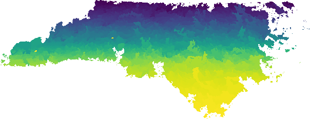
Perform the same analysis for 10,938 bridges in North Carolina:
# set computational region
g.region -ap raster=elev_state_500m

# calculate drainage directions using r.watershed
r.watershed -s elevation=elev_state_500m drainage=drain_state

# delineate all watersheds using r.watersheds
r.watersheds dir=drain_state outlets=bridges output=bridge_wsheds nproc=$(nproc)

SEE ALSO
r.flowaccumulation, r.accumulate, r.watershed, r.stream.extract, r.stream.distanceREFERENCES
Huidae Cho, January 2025. Avoid Backtracking and Burn Your Inputs: CONUS-Scale Watershed Delineation Using OpenMP. Environmental Modelling & Software 183, 106244. doi:10.1016/j.envsoft.2024.106244.AUTHOR
Huidae Cho, New Mexico State UniversitySOURCE CODE
Available at: r.watersheds source code (history)
Latest change: Sunday Dec 08 00:14:19 2024 in commit: f77724eed755334eb548323f6ad6fdf36bbef9fb
Main index | Raster index | Topics index | Keywords index | Graphical index | Full index
© 2003-2025 GRASS Development Team, GRASS GIS 8.4.1dev Reference Manual