d.vect.thematic
Displays a thematic vector map in the active graphics frame.
d.vect.thematic [-lnes] map=name [layer=string] column=name [breaks=string [,string,...]] [algorithm=string] [nclasses=integer] colors=string [,string,...] [where=sql_query] [boundary_width=integer] [boundary_color=name] [icon=string] [size=float] [icon_line=string] [icon_area=string] [legend_title=string] [legendfile=name] [--overwrite] [--verbose] [--quiet] [--qq] [--ui]
Example:
d.vect.thematic map=name column=name algorithm=int colors=string
grass.tools.Tools.d_vect_thematic(map, layer="1", column, breaks=None, algorithm=None, nclasses=None, colors, where=None, boundary_width=1, boundary_color="black", icon="basic/x", size=5, icon_line="legend/line", icon_area="legend/area", legend_title=None, legendfile=None, flags=None, overwrite=None, verbose=None, quiet=None, superquiet=None)
Example:
tools = Tools()
tools.d_vect_thematic(map="name", column="name", algorithm="int", colors="string")
This grass.tools API is experimental in version 8.5 and expected to be stable in version 8.6.
grass.script.run_command("d.vect.thematic", map, layer="1", column, breaks=None, algorithm=None, nclasses=None, colors, where=None, boundary_width=1, boundary_color="black", icon="basic/x", size=5, icon_line="legend/line", icon_area="legend/area", legend_title=None, legendfile=None, flags=None, overwrite=None, verbose=None, quiet=None, superquiet=None)
Example:
gs.run_command("d.vect.thematic", map="name", column="name", algorithm="int", colors="string")
Parameters
map=name [required]
Name of vector map
Or data source for direct OGR access
layer=string
Layer number or name
Layer number. If -1, all layers are displayed.
Default: 1
column=name [required]
Name of attribute column to be classified
breaks=string [,string,...]
Class breaks, without minimum and maximum
algorithm=string
Algorithm to use for classification
Allowed values: int, std, qua, equ, dis
int: simple intervals
std: standard deviations
qua: quantiles
equ: equiprobable (normal distribution)
dis: discontinuities
nclasses=integer
Number of classes to define
colors=string [,string,...] [required]
Colors (one per class)
where=sql_query
WHERE conditions of SQL statement without 'where' keyword
Example: income < 1000 and population >= 10000
boundary_width=integer
Boundary width
Default: 1
boundary_color=name
Boundary color
Either a standard color name, R:G:B triplet, or "none"
Default: black
icon=string
Point and centroid symbol
Allowed values: basic/arrow, basic/arrow1, basic/arrow2, basic/arrow3, basic/box, basic/circle, basic/cross1, basic/cross2, basic/cross3, basic/diamond, basic/hexagon, basic/marker, basic/octagon, basic/pin, basic/pin_dot, basic/point, basic/pushpin, basic/star, basic/triangle, basic/x, demo/muchomurka, demo/smrk, extra/4pt_star, extra/adcp, extra/airport, extra/alpha_flag, extra/bridge, extra/dim_arrow, extra/dive_flag, extra/fiducial, extra/fish, extra/half-box, extra/half-circle, extra/offbox_ne, extra/offbox_nw, extra/offbox_se, extra/offbox_sw, extra/pentagon, extra/ping, extra/ring, extra/simple_zia, extra/target, geology/circle_cross, geology/half-arrow_left, geology/half-arrow_right, geology/strike_box, geology/strike_circle, geology/strike_cleavage, geology/strike_half-bowtie, geology/strike_line, geology/strike_parallel, geology/strike_triangle, legend/area, legend/area_curved, legend/line, legend/line_crooked, n_arrows/basic_compass, n_arrows/fancy_compass, n_arrows/n_arrow1a, n_arrows/n_arrow1b, n_arrows/n_arrow2, n_arrows/n_arrow3, n_arrows/n_arrow4, n_arrows/n_arrow5, n_arrows/n_arrow6, n_arrows/n_arrow7a, n_arrows/n_arrow7b, n_arrows/n_arrow8a, n_arrows/n_arrow8b, n_arrows/n_arrow9
Default: basic/x
size=float
Symbol size
Default: 5
icon_line=string
Legend symbol for lines
Allowed values: basic/arrow, basic/arrow1, basic/arrow2, basic/arrow3, basic/box, basic/circle, basic/cross1, basic/cross2, basic/cross3, basic/diamond, basic/hexagon, basic/marker, basic/octagon, basic/pin, basic/pin_dot, basic/point, basic/pushpin, basic/star, basic/triangle, basic/x, demo/muchomurka, demo/smrk, extra/4pt_star, extra/adcp, extra/airport, extra/alpha_flag, extra/bridge, extra/dim_arrow, extra/dive_flag, extra/fiducial, extra/fish, extra/half-box, extra/half-circle, extra/offbox_ne, extra/offbox_nw, extra/offbox_se, extra/offbox_sw, extra/pentagon, extra/ping, extra/ring, extra/simple_zia, extra/target, geology/circle_cross, geology/half-arrow_left, geology/half-arrow_right, geology/strike_box, geology/strike_circle, geology/strike_cleavage, geology/strike_half-bowtie, geology/strike_line, geology/strike_parallel, geology/strike_triangle, legend/area, legend/area_curved, legend/line, legend/line_crooked, n_arrows/basic_compass, n_arrows/fancy_compass, n_arrows/n_arrow1a, n_arrows/n_arrow1b, n_arrows/n_arrow2, n_arrows/n_arrow3, n_arrows/n_arrow4, n_arrows/n_arrow5, n_arrows/n_arrow6, n_arrows/n_arrow7a, n_arrows/n_arrow7b, n_arrows/n_arrow8a, n_arrows/n_arrow8b, n_arrows/n_arrow9
Default: legend/line
icon_area=string
Legend symbol for areas
Allowed values: basic/arrow, basic/arrow1, basic/arrow2, basic/arrow3, basic/box, basic/circle, basic/cross1, basic/cross2, basic/cross3, basic/diamond, basic/hexagon, basic/marker, basic/octagon, basic/pin, basic/pin_dot, basic/point, basic/pushpin, basic/star, basic/triangle, basic/x, demo/muchomurka, demo/smrk, extra/4pt_star, extra/adcp, extra/airport, extra/alpha_flag, extra/bridge, extra/dim_arrow, extra/dive_flag, extra/fiducial, extra/fish, extra/half-box, extra/half-circle, extra/offbox_ne, extra/offbox_nw, extra/offbox_se, extra/offbox_sw, extra/pentagon, extra/ping, extra/ring, extra/simple_zia, extra/target, geology/circle_cross, geology/half-arrow_left, geology/half-arrow_right, geology/strike_box, geology/strike_circle, geology/strike_cleavage, geology/strike_half-bowtie, geology/strike_line, geology/strike_parallel, geology/strike_triangle, legend/area, legend/area_curved, legend/line, legend/line_crooked, n_arrows/basic_compass, n_arrows/fancy_compass, n_arrows/n_arrow1a, n_arrows/n_arrow1b, n_arrows/n_arrow2, n_arrows/n_arrow3, n_arrows/n_arrow4, n_arrows/n_arrow5, n_arrows/n_arrow6, n_arrows/n_arrow7a, n_arrows/n_arrow7b, n_arrows/n_arrow8a, n_arrows/n_arrow8b, n_arrows/n_arrow9
Default: legend/area
legend_title=string
Thematic map title
legendfile=name
[DEPRECATED] Output legend file
-l
Create legend information and send to stdout
-n
Do not draw map, only output the legend information
-e
[DEPRECATED] When printing legend info, include extended statistical info from classification algorithm
-s
Do not show this layer in vector legend
--overwrite
Allow output files to overwrite existing files
--help
Print usage summary
--verbose
Verbose module output
--quiet
Quiet module output
--qq
Very quiet module output
--ui
Force launching GUI dialog
map : str, required
Name of vector map
Or data source for direct OGR access
Used as: input, vector, name
layer : str, optional
Layer number or name
Layer number. If -1, all layers are displayed.
Used as: input, layer
Default: 1
column : str, required
Name of attribute column to be classified
Used as: input, dbcolumn, name
breaks : str | list[str], optional
Class breaks, without minimum and maximum
algorithm : str, optional
Algorithm to use for classification
Allowed values: int, std, qua, equ, dis
int: simple intervals
std: standard deviations
qua: quantiles
equ: equiprobable (normal distribution)
dis: discontinuities
nclasses : int, optional
Number of classes to define
colors : str | list[str], required
Colors (one per class)
Used as: color
where : str, optional
WHERE conditions of SQL statement without 'where' keyword
Example: income < 1000 and population >= 10000
Used as: input, sql_query, sql_query
boundary_width : int, optional
Boundary width
Default: 1
boundary_color : str, optional
Boundary color
Either a standard color name, R:G:B triplet, or "none"
Used as: input, color, name
Default: black
icon : str, optional
Point and centroid symbol
Allowed values: basic/arrow, basic/arrow1, basic/arrow2, basic/arrow3, basic/box, basic/circle, basic/cross1, basic/cross2, basic/cross3, basic/diamond, basic/hexagon, basic/marker, basic/octagon, basic/pin, basic/pin_dot, basic/point, basic/pushpin, basic/star, basic/triangle, basic/x, demo/muchomurka, demo/smrk, extra/4pt_star, extra/adcp, extra/airport, extra/alpha_flag, extra/bridge, extra/dim_arrow, extra/dive_flag, extra/fiducial, extra/fish, extra/half-box, extra/half-circle, extra/offbox_ne, extra/offbox_nw, extra/offbox_se, extra/offbox_sw, extra/pentagon, extra/ping, extra/ring, extra/simple_zia, extra/target, geology/circle_cross, geology/half-arrow_left, geology/half-arrow_right, geology/strike_box, geology/strike_circle, geology/strike_cleavage, geology/strike_half-bowtie, geology/strike_line, geology/strike_parallel, geology/strike_triangle, legend/area, legend/area_curved, legend/line, legend/line_crooked, n_arrows/basic_compass, n_arrows/fancy_compass, n_arrows/n_arrow1a, n_arrows/n_arrow1b, n_arrows/n_arrow2, n_arrows/n_arrow3, n_arrows/n_arrow4, n_arrows/n_arrow5, n_arrows/n_arrow6, n_arrows/n_arrow7a, n_arrows/n_arrow7b, n_arrows/n_arrow8a, n_arrows/n_arrow8b, n_arrows/n_arrow9
Default: basic/x
size : float, optional
Symbol size
Default: 5
icon_line : str, optional
Legend symbol for lines
Allowed values: basic/arrow, basic/arrow1, basic/arrow2, basic/arrow3, basic/box, basic/circle, basic/cross1, basic/cross2, basic/cross3, basic/diamond, basic/hexagon, basic/marker, basic/octagon, basic/pin, basic/pin_dot, basic/point, basic/pushpin, basic/star, basic/triangle, basic/x, demo/muchomurka, demo/smrk, extra/4pt_star, extra/adcp, extra/airport, extra/alpha_flag, extra/bridge, extra/dim_arrow, extra/dive_flag, extra/fiducial, extra/fish, extra/half-box, extra/half-circle, extra/offbox_ne, extra/offbox_nw, extra/offbox_se, extra/offbox_sw, extra/pentagon, extra/ping, extra/ring, extra/simple_zia, extra/target, geology/circle_cross, geology/half-arrow_left, geology/half-arrow_right, geology/strike_box, geology/strike_circle, geology/strike_cleavage, geology/strike_half-bowtie, geology/strike_line, geology/strike_parallel, geology/strike_triangle, legend/area, legend/area_curved, legend/line, legend/line_crooked, n_arrows/basic_compass, n_arrows/fancy_compass, n_arrows/n_arrow1a, n_arrows/n_arrow1b, n_arrows/n_arrow2, n_arrows/n_arrow3, n_arrows/n_arrow4, n_arrows/n_arrow5, n_arrows/n_arrow6, n_arrows/n_arrow7a, n_arrows/n_arrow7b, n_arrows/n_arrow8a, n_arrows/n_arrow8b, n_arrows/n_arrow9
Default: legend/line
icon_area : str, optional
Legend symbol for areas
Allowed values: basic/arrow, basic/arrow1, basic/arrow2, basic/arrow3, basic/box, basic/circle, basic/cross1, basic/cross2, basic/cross3, basic/diamond, basic/hexagon, basic/marker, basic/octagon, basic/pin, basic/pin_dot, basic/point, basic/pushpin, basic/star, basic/triangle, basic/x, demo/muchomurka, demo/smrk, extra/4pt_star, extra/adcp, extra/airport, extra/alpha_flag, extra/bridge, extra/dim_arrow, extra/dive_flag, extra/fiducial, extra/fish, extra/half-box, extra/half-circle, extra/offbox_ne, extra/offbox_nw, extra/offbox_se, extra/offbox_sw, extra/pentagon, extra/ping, extra/ring, extra/simple_zia, extra/target, geology/circle_cross, geology/half-arrow_left, geology/half-arrow_right, geology/strike_box, geology/strike_circle, geology/strike_cleavage, geology/strike_half-bowtie, geology/strike_line, geology/strike_parallel, geology/strike_triangle, legend/area, legend/area_curved, legend/line, legend/line_crooked, n_arrows/basic_compass, n_arrows/fancy_compass, n_arrows/n_arrow1a, n_arrows/n_arrow1b, n_arrows/n_arrow2, n_arrows/n_arrow3, n_arrows/n_arrow4, n_arrows/n_arrow5, n_arrows/n_arrow6, n_arrows/n_arrow7a, n_arrows/n_arrow7b, n_arrows/n_arrow8a, n_arrows/n_arrow8b, n_arrows/n_arrow9
Default: legend/area
legend_title : str, optional
Thematic map title
legendfile : str, optional
[DEPRECATED] Output legend file
Used as: output, file, name
flags : str, optional
Allowed values: l, n, e, s
l
Create legend information and send to stdout
n
Do not draw map, only output the legend information
e
[DEPRECATED] When printing legend info, include extended statistical info from classification algorithm
s
Do not show this layer in vector legend
overwrite : bool, optional
Allow output files to overwrite existing files
Default: None
verbose : bool, optional
Verbose module output
Default: None
quiet : bool, optional
Quiet module output
Default: None
superquiet : bool, optional
Very quiet module output
Default: None
Returns:
result : grass.tools.support.ToolResult | None
If the tool produces text as standard output, a ToolResult object will be returned. Otherwise, None will be returned.
Raises:
grass.tools.ToolError: When the tool ended with an error.
map : str, required
Name of vector map
Or data source for direct OGR access
Used as: input, vector, name
layer : str, optional
Layer number or name
Layer number. If -1, all layers are displayed.
Used as: input, layer
Default: 1
column : str, required
Name of attribute column to be classified
Used as: input, dbcolumn, name
breaks : str | list[str], optional
Class breaks, without minimum and maximum
algorithm : str, optional
Algorithm to use for classification
Allowed values: int, std, qua, equ, dis
int: simple intervals
std: standard deviations
qua: quantiles
equ: equiprobable (normal distribution)
dis: discontinuities
nclasses : int, optional
Number of classes to define
colors : str | list[str], required
Colors (one per class)
Used as: color
where : str, optional
WHERE conditions of SQL statement without 'where' keyword
Example: income < 1000 and population >= 10000
Used as: input, sql_query, sql_query
boundary_width : int, optional
Boundary width
Default: 1
boundary_color : str, optional
Boundary color
Either a standard color name, R:G:B triplet, or "none"
Used as: input, color, name
Default: black
icon : str, optional
Point and centroid symbol
Allowed values: basic/arrow, basic/arrow1, basic/arrow2, basic/arrow3, basic/box, basic/circle, basic/cross1, basic/cross2, basic/cross3, basic/diamond, basic/hexagon, basic/marker, basic/octagon, basic/pin, basic/pin_dot, basic/point, basic/pushpin, basic/star, basic/triangle, basic/x, demo/muchomurka, demo/smrk, extra/4pt_star, extra/adcp, extra/airport, extra/alpha_flag, extra/bridge, extra/dim_arrow, extra/dive_flag, extra/fiducial, extra/fish, extra/half-box, extra/half-circle, extra/offbox_ne, extra/offbox_nw, extra/offbox_se, extra/offbox_sw, extra/pentagon, extra/ping, extra/ring, extra/simple_zia, extra/target, geology/circle_cross, geology/half-arrow_left, geology/half-arrow_right, geology/strike_box, geology/strike_circle, geology/strike_cleavage, geology/strike_half-bowtie, geology/strike_line, geology/strike_parallel, geology/strike_triangle, legend/area, legend/area_curved, legend/line, legend/line_crooked, n_arrows/basic_compass, n_arrows/fancy_compass, n_arrows/n_arrow1a, n_arrows/n_arrow1b, n_arrows/n_arrow2, n_arrows/n_arrow3, n_arrows/n_arrow4, n_arrows/n_arrow5, n_arrows/n_arrow6, n_arrows/n_arrow7a, n_arrows/n_arrow7b, n_arrows/n_arrow8a, n_arrows/n_arrow8b, n_arrows/n_arrow9
Default: basic/x
size : float, optional
Symbol size
Default: 5
icon_line : str, optional
Legend symbol for lines
Allowed values: basic/arrow, basic/arrow1, basic/arrow2, basic/arrow3, basic/box, basic/circle, basic/cross1, basic/cross2, basic/cross3, basic/diamond, basic/hexagon, basic/marker, basic/octagon, basic/pin, basic/pin_dot, basic/point, basic/pushpin, basic/star, basic/triangle, basic/x, demo/muchomurka, demo/smrk, extra/4pt_star, extra/adcp, extra/airport, extra/alpha_flag, extra/bridge, extra/dim_arrow, extra/dive_flag, extra/fiducial, extra/fish, extra/half-box, extra/half-circle, extra/offbox_ne, extra/offbox_nw, extra/offbox_se, extra/offbox_sw, extra/pentagon, extra/ping, extra/ring, extra/simple_zia, extra/target, geology/circle_cross, geology/half-arrow_left, geology/half-arrow_right, geology/strike_box, geology/strike_circle, geology/strike_cleavage, geology/strike_half-bowtie, geology/strike_line, geology/strike_parallel, geology/strike_triangle, legend/area, legend/area_curved, legend/line, legend/line_crooked, n_arrows/basic_compass, n_arrows/fancy_compass, n_arrows/n_arrow1a, n_arrows/n_arrow1b, n_arrows/n_arrow2, n_arrows/n_arrow3, n_arrows/n_arrow4, n_arrows/n_arrow5, n_arrows/n_arrow6, n_arrows/n_arrow7a, n_arrows/n_arrow7b, n_arrows/n_arrow8a, n_arrows/n_arrow8b, n_arrows/n_arrow9
Default: legend/line
icon_area : str, optional
Legend symbol for areas
Allowed values: basic/arrow, basic/arrow1, basic/arrow2, basic/arrow3, basic/box, basic/circle, basic/cross1, basic/cross2, basic/cross3, basic/diamond, basic/hexagon, basic/marker, basic/octagon, basic/pin, basic/pin_dot, basic/point, basic/pushpin, basic/star, basic/triangle, basic/x, demo/muchomurka, demo/smrk, extra/4pt_star, extra/adcp, extra/airport, extra/alpha_flag, extra/bridge, extra/dim_arrow, extra/dive_flag, extra/fiducial, extra/fish, extra/half-box, extra/half-circle, extra/offbox_ne, extra/offbox_nw, extra/offbox_se, extra/offbox_sw, extra/pentagon, extra/ping, extra/ring, extra/simple_zia, extra/target, geology/circle_cross, geology/half-arrow_left, geology/half-arrow_right, geology/strike_box, geology/strike_circle, geology/strike_cleavage, geology/strike_half-bowtie, geology/strike_line, geology/strike_parallel, geology/strike_triangle, legend/area, legend/area_curved, legend/line, legend/line_crooked, n_arrows/basic_compass, n_arrows/fancy_compass, n_arrows/n_arrow1a, n_arrows/n_arrow1b, n_arrows/n_arrow2, n_arrows/n_arrow3, n_arrows/n_arrow4, n_arrows/n_arrow5, n_arrows/n_arrow6, n_arrows/n_arrow7a, n_arrows/n_arrow7b, n_arrows/n_arrow8a, n_arrows/n_arrow8b, n_arrows/n_arrow9
Default: legend/area
legend_title : str, optional
Thematic map title
legendfile : str, optional
[DEPRECATED] Output legend file
Used as: output, file, name
flags : str, optional
Allowed values: l, n, e, s
l
Create legend information and send to stdout
n
Do not draw map, only output the legend information
e
[DEPRECATED] When printing legend info, include extended statistical info from classification algorithm
s
Do not show this layer in vector legend
overwrite : bool, optional
Allow output files to overwrite existing files
Default: None
verbose : bool, optional
Verbose module output
Default: None
quiet : bool, optional
Quiet module output
Default: None
superquiet : bool, optional
Very quiet module output
Default: None
DESCRIPTION
d.vect.thematic draws thematic choropleth vector maps based on an attribute column or an expression involving several columns. It takes a list of class breaks (excluding the minimum and maximum values) and a list of colors to apply to the classes (has to be the number of class breaks + 1).
Instead of a list of class breaks, the user can also chose a classification algorithm and a number of classes (nbclasses). See the v.class for more information on these different algorithms.
NOTES
The -l flag instructs the module to print legend information in vector legend format as described in d.legend.vect to standard output for further use in graphical software. When combined with the verbose flag, the legend information will be extended with some additional statistical information. If the -n flag is set, the module will only print the legend information without drawing the map.
Option legendfile, is deprecated, instead use the GRASS_LEGEND_FILE environmental variable (see d.legend.vect) to save legend into a file. Flag -e is deprecated, instead use verbose flag.
EXAMPLES
Thematic map with classes
d.vect.thematic -l map=communes3 column=pop \
  breaks=111393.250000,222785.500000,334177.750000 \
  colors="255:0:0,0:255:0,0:0:255,0,0,0"
Thematic map with calculated class breaks
The following example uses a calculated attribute (density = pop/area)
and the standard deviation algorithm to calculate class breaks for 5
classes:
d.vect.thematic -l map=communes2 column=pop/area algorithm=std \
  nbclasses=5 colors="0:0:255,50:100:255,255:100:50,255:0:0,156:0:0"
Thematic map with legend
Example for the North Carolina sample dataset, colorizing basin polygons by average elevation and displaying school capacity:
# create watersheds from elevation map
g.region raster=elevation
r.watershed elevation=elevation threshold=10000 basin=basins_10k

# convert raster to vector
r.to.vect input=basins_10k output=basins_10k type=area column=basin_num

# upload raster statistics to each polygon in vector map
v.rast.stats map=basins_10k raster=elevation column_prefix=elev

# open a graphical display
d.mon wx0

# draw thematic polygons and specify legend title
d.vect.thematic map=basins_10k column=elev_average algorithm=int \
  nclasses=5 colors=0:195:176,39:255:0,251:253:0,242:127:11,193:126:60 \
  legend_title="Average elevation (m)"

# draw thematic points and specify legend title
d.vect.thematic map=schools_wake@PERMANENT column=CORECAPACI algorithm=std \
  nclasses=3 colors=149:203:255,45:143:240,0:81:161 icon=basic/circle size=15 \
  legend_title="School capacity"

# and finally draw legend
d.legend.vect -b at=2,80 font=Sans symbol_size=25
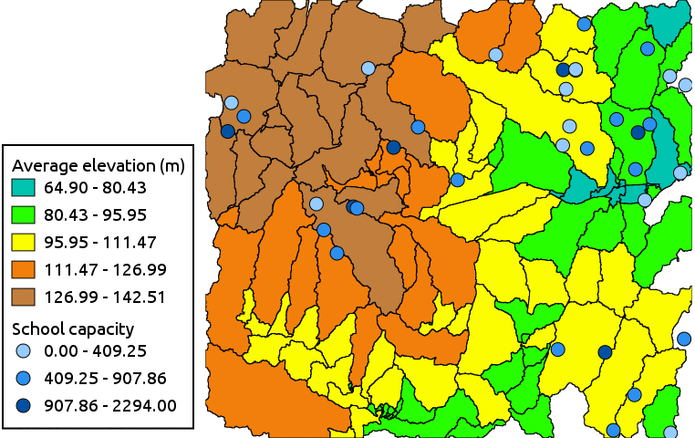
Thematic map of average elevation and school capacity
SEE ALSO
v.class, d.legend.vect, d.vect, d.graph, v.univar
Check also Python module from AddOns: d.vect.thematic2
AUTHOR
Moritz Lennert
SOURCE CODE
Available at: d.vect.thematic source code
(history)
Latest change: Friday Apr 17 01:04:26 2026 in commit 32a1433