r.grow.distance
Generates a raster map containing distances to nearest raster features and/or the value of the nearest non-null cell.
r.grow.distance [-mn] input=name [distance=name] [value=name] [metric=string] [minimum_distance=float] [maximum_distance=float] [--overwrite] [--verbose] [--quiet] [--qq] [--ui]
Example:
r.grow.distance input=name
grass.tools.Tools.r_grow_distance(input, distance=None, value=None, metric="euclidean", minimum_distance=None, maximum_distance=None, flags=None, overwrite=None, verbose=None, quiet=None, superquiet=None)
Example:
tools = Tools()
tools.r_grow_distance(input="name")
This grass.tools API is experimental in version 8.5 and expected to be stable in version 8.6.
grass.script.run_command("r.grow.distance", input, distance=None, value=None, metric="euclidean", minimum_distance=None, maximum_distance=None, flags=None, overwrite=None, verbose=None, quiet=None, superquiet=None)
Example:
gs.run_command("r.grow.distance", input="name")
Parameters
input=name [required]
Name of input raster map
distance=name
Name for distance output raster map
value=name
Name for value output raster map
metric=string
Metric
Allowed values: euclidean, squared, maximum, manhattan, geodesic
Default: euclidean
minimum_distance=float
Minimum distance threshold
maximum_distance=float
Maximum distance threshold
-m
Output distances in meters instead of map units
-n
Calculate distance to nearest NULL cell
--overwrite
Allow output files to overwrite existing files
--help
Print usage summary
--verbose
Verbose module output
--quiet
Quiet module output
--qq
Very quiet module output
--ui
Force launching GUI dialog
input : str | np.ndarray, required
Name of input raster map
Used as: input, raster, name
distance : str | type(np.ndarray) | type(np.array) | type(gs.array.array), optional
Name for distance output raster map
Used as: output, raster, name
value : str | type(np.ndarray) | type(np.array) | type(gs.array.array), optional
Name for value output raster map
Used as: output, raster, name
metric : str, optional
Metric
Allowed values: euclidean, squared, maximum, manhattan, geodesic
Default: euclidean
minimum_distance : float, optional
Minimum distance threshold
maximum_distance : float, optional
Maximum distance threshold
flags : str, optional
Allowed values: m, n
m
Output distances in meters instead of map units
n
Calculate distance to nearest NULL cell
overwrite : bool, optional
Allow output files to overwrite existing files
Default: None
verbose : bool, optional
Verbose module output
Default: None
quiet : bool, optional
Quiet module output
Default: None
superquiet : bool, optional
Very quiet module output
Default: None
Returns:
result : grass.tools.support.ToolResult | np.ndarray | tuple[np.ndarray] | None
If the tool produces text as standard output, a ToolResult object will be returned. Otherwise, None will be returned. If an array type (e.g., np.ndarray) is used for one of the raster outputs, the result will be an array and will have the shape corresponding to the computational region. If an array type is used for more than one raster output, the result will be a tuple of arrays.
Raises:
grass.tools.ToolError: When the tool ended with an error.
input : str, required
Name of input raster map
Used as: input, raster, name
distance : str, optional
Name for distance output raster map
Used as: output, raster, name
value : str, optional
Name for value output raster map
Used as: output, raster, name
metric : str, optional
Metric
Allowed values: euclidean, squared, maximum, manhattan, geodesic
Default: euclidean
minimum_distance : float, optional
Minimum distance threshold
maximum_distance : float, optional
Maximum distance threshold
flags : str, optional
Allowed values: m, n
m
Output distances in meters instead of map units
n
Calculate distance to nearest NULL cell
overwrite : bool, optional
Allow output files to overwrite existing files
Default: None
verbose : bool, optional
Verbose module output
Default: None
quiet : bool, optional
Quiet module output
Default: None
superquiet : bool, optional
Very quiet module output
Default: None
DESCRIPTION
r.grow.distance generates raster maps representing the distance to the nearest non-null cell in the input map and/or the value of the nearest non-null cell.
NOTES
The flag -n calculates the respective pixel distances to the nearest NULL cell.
The user has the option of specifying five different metrics which control the geometry in which grown cells are created, (controlled by the metric parameter): Euclidean, Squared, Manhattan, Maximum, and Geodesic.
The Euclidean distance or Euclidean metric is the "ordinary" distance between two points that one would measure with a ruler, which can be proven by repeated application of the Pythagorean theorem. The formula is given by:
d(dx,dy) = sqrt(dx^2 + dy^2)
Cells grown using this metric would form isolines of distance that are circular from a given point, with the distance given by the radius.
The Squared metric is the Euclidean distance squared, i.e. it simply omits the square-root calculation. This may be faster, and is sufficient if only relative values are required.
The Manhattan metric, or Taxicab geometry, is a form of geometry in which the usual metric of Euclidean geometry is replaced by a new metric in which the distance between two points is the sum of the (absolute) differences of their coordinates. The name alludes to the grid layout of most streets on the island of Manhattan, which causes the shortest path a car could take between two points in the city to have length equal to the points' distance in taxicab geometry. The formula is given by:
d(dx,dy) = abs(dx) + abs(dy)
where cells grown using this metric would form isolines of distance that are rhombus-shaped from a given point.
The Maximum metric is given by the formula
d(dx,dy) = max(abs(dx),abs(dy))
where the isolines of distance from a point are squares.
The Geodesic metric is calculated as geodesic distance, to be used only in latitude-longitude coordinate reference system. It is recommended to use it along with the -m flag in order to output distances in meters instead of map units.
If minimum_distance is given, all cells with a distance smaller than minimum_distance will be set to NULL.
If maximum_distance is given, all cells with a distance larger than maximum_distance will be set to NULL. The resultant output is equivalent to a buffer.
If both minimum_distance and maximum_distance are given, the result will be similar to a doughnut, a restricted belt for a given distance range. All cells outside this distance range will be set to NULL.
EXAMPLES
Distance from the streams network
North Carolina sample dataset:
g.region raster=streams_derived -p
r.grow.distance input=streams_derived distance=dist_from_streams
r.colors map=dist_from_streams color=rainbow
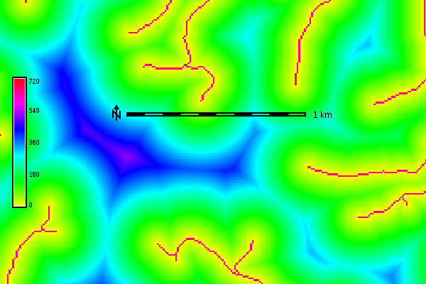
Euclidean distance from the streams network in meters (map subset)
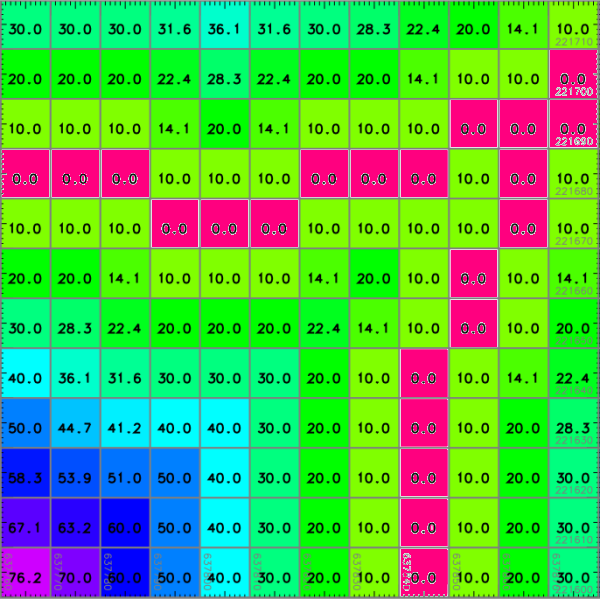
Euclidean distance from the streams network in meters (detail, numbers
shown with d.rast.num)
Distance from sea in meters in latitude-longitude CRS
g.region raster=sea -p
r.grow.distance -m input=sea distance=dist_from_sea_geodetic metric=geodesic
r.colors map=dist_from_sea_geodetic color=rainbow
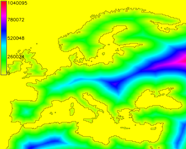
Geodesic distances to sea in meters
SEE ALSO
r.grow, r.distance, r.buffer, r.cost, r.patch
Wikipedia Entry: Euclidean
Metric
Wikipedia Entry: Manhattan
Metric
AUTHOR
Glynn Clements
SOURCE CODE
Available at: r.grow.distance source code
(history)
Latest change: Saturday Oct 25 22:50:58 2025 in commit ee87f21