r.li.renyi
Calculates Renyi's diversity index on a raster map
r.li.renyi input=name config=name alpha=string output=name [--overwrite] [--verbose] [--quiet] [--qq] [--ui]
Example:
r.li.renyi input=name config=name alpha=string output=name
grass.tools.Tools.r_li_renyi(input, config, alpha, output, overwrite=None, verbose=None, quiet=None, superquiet=None)
Example:
tools = Tools()
tools.r_li_renyi(input="name", config="name", alpha="string", output="name")
This grass.tools API is experimental in version 8.5 and expected to be stable in version 8.6.
grass.script.run_command("r.li.renyi", input, config, alpha, output, overwrite=None, verbose=None, quiet=None, superquiet=None)
Example:
gs.run_command("r.li.renyi", input="name", config="name", alpha="string", output="name")
Parameters
input=name [required]
Name of input raster map
config=name [required]
Configuration file
alpha=string [required]
Alpha value is the order of the generalized entropy
output=name [required]
Name for output raster map
--overwrite
Allow output files to overwrite existing files
--help
Print usage summary
--verbose
Verbose module output
--quiet
Quiet module output
--qq
Very quiet module output
--ui
Force launching GUI dialog
input : str | np.ndarray, required
Name of input raster map
Used as: input, raster, name
config : str | io.StringIO, required
Configuration file
Used as: input, file, name
alpha : str, required
Alpha value is the order of the generalized entropy
output : str | type(np.ndarray) | type(np.array) | type(gs.array.array), required
Name for output raster map
Used as: output, raster, name
overwrite : bool, optional
Allow output files to overwrite existing files
Default: None
verbose : bool, optional
Verbose module output
Default: None
quiet : bool, optional
Quiet module output
Default: None
superquiet : bool, optional
Very quiet module output
Default: None
Returns:
result : grass.tools.support.ToolResult | np.ndarray | tuple[np.ndarray] | None
If the tool produces text as standard output, a ToolResult object will be returned. Otherwise, None will be returned. If an array type (e.g., np.ndarray) is used for one of the raster outputs, the result will be an array and will have the shape corresponding to the computational region. If an array type is used for more than one raster output, the result will be a tuple of arrays.
Raises:
grass.tools.ToolError: When the tool ended with an error.
input : str, required
Name of input raster map
Used as: input, raster, name
config : str, required
Configuration file
Used as: input, file, name
alpha : str, required
Alpha value is the order of the generalized entropy
output : str, required
Name for output raster map
Used as: output, raster, name
overwrite : bool, optional
Allow output files to overwrite existing files
Default: None
verbose : bool, optional
Verbose module output
Default: None
quiet : bool, optional
Quiet module output
Default: None
superquiet : bool, optional
Very quiet module output
Default: None
DESCRIPTION
r.li.renyi calculates the "Renyi's diversity index" as:
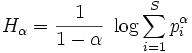
with:
- H: Renyi entropy
- alpha: order of the generalized entropy
- i: patch type
- S: number of different patch types
- p_i: proportional abundance of patch type i
NOTES
Do not use absolute path names for the config and output
file/map parameters. If the "moving window" method was selected in
g.gui.rlisetup, then the output will be a raster map, otherwise an
ASCII file will be generated in the folder
C:\Users\userxy\AppData\Roaming\GRASS8\r.li\output\ (MS-Windows) or
$HOME/.grass8/r.li/output/ (GNU/Linux).
If the input raster map contains only NULL values then r.li.renyi returns NULL.
EXAMPLES
To calculate Renyi's diversity index on map my_map, using my_conf configuration file (previously defined with g.gui.rlisetup) and saving results in my_out, run:
r.li.renyi input=my_map conf=my_conf output=my_out alpha=0.6
Forest map (Spearfish sample dataset) example:
g.region raster=landcover.30m -p
r.mapcalc "forests = if(landcover.30m >= 41 && landcover.30m <= 43,1,null())"
r.li.renyi input=forests conf=movwindow7 out=forests_renyi_mov7_a06 alpha=0.6
r.univar forests_renyi_mov7_a06
Forest map (North Carolina sample dataset) example:
g.region raster=landclass96 -p
r.mapcalc "forests = if(landclass96 == 5, 1, null() )"
r.li.renyi input=forests conf=movwindow7 out=forests_renyi_mov7

# verify
r.univar forests_renyi_mov7
r.to.vect input=forests output=forests type=area
d.mon wx0
d.rast forests_renyi_mov7
d.vect forests type=boundary
SEE ALSO
r.li (package overview), g.gui.rlisetup
REFERENCES
McGarigal, K., and B. J. Marks. 1995. FRAGSTATS: spatial pattern analysis program for quantifying landscape structure. USDA For. Serv. Gen. Tech. Rep. PNW-351. (PDF)
AUTHORS
Luca Delucchi and Duccio Rocchini, Fondazione E. Mach (Italy), based on the r.li.shannon code developed by Serena Pallecchi, student of Computer Science University of Pisa (Italy).
SOURCE CODE
Available at: r.li.renyi source code
(history)
Latest change: Tuesday Apr 29 06:19:47 2025 in commit 12f893b