NAME
i.sentinel.import - Imports Sentinel satellite data downloaded from Copernicus Open Access Hub using i.sentinel.download.KEYWORDS
imagery, satellite, Sentinel, importSYNOPSIS
Flags:
- -r
- Reproject raster data using r.import if needed
- -l
- Link raster data instead of importing
- -c
- Import cloud masks as vector maps
- -p
- Print raster data to be imported and exit
- --help
- Print usage summary
- --verbose
- Verbose module output
- --quiet
- Quiet module output
- --ui
- Force launching GUI dialog
Parameters:
- input=name [required]
- Name for input directory where downloaded Sentinel data lives
- pattern=string
- File name pattern to import
- memory=integer
- Maximum memory to be used (in MB)
- Cache size for raster rows
- Default: 300
Table of contents
DESCRIPTION
The i.sentinel.import module allows importing Copernicus Sentinel products downloaded by the i.sentinel.download module.By default i.sentinel.import imports all Sentinel scene files found in the input directory by r.import. Note that in the case that spatial reference system of input data differs from GRASS GIS location, the input data are reprojected. To speed up this process, a higher than default value can be specified for the memory option.
Optionally input data can be linked by r.external when -l is given. Note that linking data requires that Sentinel input data and GRASS location have the same spatial reference system (e.g., the same UTM zone).
The number of imported Sentinel bands can be optionally reduced by the pattern option. Below an overview of the Sentinel-2 MSI band spatial resolutions:
| Spatial resolution [m] | S2 Bands |
|---|---|
| 10 | B2, B3, B4, B8 |
| 20 | B5, B6, B7, B8a, B11, B12 |
| 60 | B1, B9, B10 |
NOTES
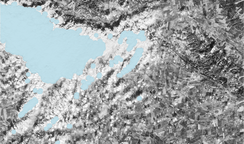
If -c flag is given, than also cloud mask file is imported as vector map if available. The name of created vector map is determined from input Sentinel product.
EXAMPLES
List Sentinel bands
At first, print list of raster files to be imported by -p. For each file also projection match with current location is printed including detected input data EPSG code:i.sentinel.import -p input=data data/S2B_MSIL1C_20180216T102059_N0206_R065_T32UPB_20180216T140508.SAFE/GRANULE/.../T32UPB_20180216T102059_B04.jp2 1 (EPSG: 32632) data/S2B_MSIL1C_20180216T102059_N0206_R065_T32UPB_20180216T140508.SAFE/GRANULE/.../T32UPB_20180216T102059_B07.jp2 1 (EPSG: 32632) data/S2B_MSIL1C_20180216T102059_N0206_R065_T32UPB_20180216T140508.SAFE/GRANULE/.../T32UPB_20180216T102059_B11.jp2 1 (EPSG: 32632)
Import Sentinel bands
Import all Sentinel bands found in data directory:i.sentinel.import input=data
Limit import to only to 4th and 8th bands:
i.sentinel.import input=data pattern='B0(4|8)'
Limit import to only to all bands with 10m resolution (excluding AOT, WVP, ... bands):
i.sentinel.import input=data pattern='B0(2|3|4|8)_10m'
Link data and import also cloud mask file:
i.sentinel.import -l -c input=data

Fig: Band 4 with imported cloud mask
SEE ALSO
Overview of i.sentinel toolseti.sentinel.download, i.sentinel.preproc, i.sentinel.mask, r.import, r.external, v.import
See also GRASS GIS Workshop in Jena for usage examples.
AUTHOR
Martin Landa, GeoForAll Lab, CTU in Prague, Czech Republic with support of OpenGeoLabs companyLast changed: $Date: 2019-01-06 23:11:12 +0100 (Sun, 06 Jan 2019) $
SOURCE CODE
Available at: i.sentinel.import source code (history)
Main index | Imagery index | Topics index | Keywords index | Graphical index | Full index
© 2003-2019 GRASS Development Team, GRASS GIS 7.4.5svn Reference Manual