Note: This document is for an older version of GRASS GIS that has been discontinued. You should upgrade, and read the current manual page.
NAME
g.projpicker - Queries projection information spatially.KEYWORDS
general, projection, create locationSYNOPSIS
Flags:
- -l
- Coordinates in latitude and longitude instead of east and north
- -p
- Print parsed geometries in a list form for input validation and exit
- -n
- Do not print header for plain output format
- -g
- Start GUI
- -1
- Allow only one selection in GUI
- --overwrite
- Allow output files to overwrite existing files
- --help
- Print usage summary
- --verbose
- Verbose module output
- --quiet
- Quiet module output
- --ui
- Force launching GUI dialog
Parameters:
- coordinates=east,north[,east,north,...]
- Coordinates
- operator=string
- Logical operator for coordinates
- Options: and, or, xor
- Default: and
- query=string
- Query string
- input=name
- Name of input query file (- for stdin)
- output=name
- Name for output file (- for stdout)
- Default: -
- format=string
- Output file format
- Options: plain, json, pretty, sqlite, srid
- Default: plain
- separator=character
- Separator for plain and srid output formats; some projection names contain commas
- Special characters: pipe, comma, space, tab, newline
- Default: pipe for plain; newline for srid
- bbox_map=name
- Name for output vector map with bounding box lines
Table of contents
DESCRIPTION
g.projpicker queries projections spatially. It is a wrapper that invokes the ProjPicker module internally. Check its documentation for more details including installation and the query syntax.NOTES
A query string can be read from one of the coordinates (with operator), query, and input options, but not from more than one source. When an input file is used, one keyword or one geometry must be defined per line. Otherwise, invalid lines will be ignored. The -p flag can be used to validate the query syntax.Coordinate systems
The projection of the current GRASS location is not used for queries. Instead, non-latitude/longitude coordinates are considered x and y in an unknown unit that needs to be queried. The coordinates option takes longitude,latitude (without the -l flag) or latitude,longitude pairs (with the -l flag) in degrees. To use x-y coordinates, either the query or input option must be used. Two keywords (latlon and xy) can be used to switch between coordinate systems. By default, latlon is assumed and longitude,latitude as in the coordinates options is not supported in the query and input options. The query syntax is case-sensitive.Coordinate formats
Various coordinate formats are supported. For the latlon coordinate system, the following points are all identical:################################ # decimal degrees and separators ################################ 34.2348,-83.8677 # comma 34.2348 -83.8677 # whitespace #################################################### # degree, minute, and second symbols # degree: ° (U+00B0, °, alt+0 in xterm), o, d # minute: ' (U+0027, '), ′ (U+2032, ′), m # second: " (U+0022, "), ″ (U+2033, ″), # '' (U+0027 U+0027, ' '), s #################################################### 34.2348° -83.8677° # without minutes, seconds, and [SNWE] 34°14.088' -83°52.062' # without seconds and [SNWE] 34°14'5.28" -83°52'3.72" # without [SNWE] 34.2348°N 83.8677°W # without minutes and seconds 34°14.088'N 83°52.062'W # without seconds 34°14'5.28"N 83°52'3.72"W # full 34°14′5.28″N 83°52′3.72″W # full using U+2032 and U+2033 34o14'5.28''N 83o52'3.72''W # full using o' and '' 34d14m5.28sN 83d52m3.72sW # full using dms 34:14:5.28N 83:52:3.72W # full using : 34:14:5.28 -83:52:3.72 # without [SNWE] 34:14.088 -83:52.062 # without seconds and [SNWE]
xy
396255,1374239
396255 1374239
Units
The unit= keyword can be used to restrict queries to a specific unit. By default, it is set to unit=any and the full list of supported units is as follows:- degree
- degree minute second hemisphere
- grad
- meter
- kilometer
- 50 kilometers
- 150 kilometers
- link
- foot
- US foot
- British foot (1936)
- British foot (Sears 1922)
- British yard (Sears 1922)
- British chain (Benoit 1895 B)
- British chain (Sears 1922 truncated)
- British chain (Sears 1922)
- Clarke's link
- Clarke's foot
- Clarke's yard
- German legal meter
- Gold Coast foot
- Indian yard (1937)
- Indian yard
Geometry types
Three geometry types including point, poly, and bbox are supported. Both lines and boundaries are supported by the same poly geometry type. Regardless of the coordinate system, bbox geometries always take the south, north, west, and east coordinates in that order of a bounding box.See the following example:
# point geometry
# starts in latlon
point
10,20
xy
3,4

# poly 1
latlon
poly
10,20
30,40
# poly 2 in xy
# new coordinate system always starts a new geometry
xy
5,6
7,8
# comment ignored and poly 2 continues
9,10

# but not this one because there is a blank line above
# start poly 3
11,12
13,14

# bbox
latlon
bbox
10,20,30,40
xy
5,6,7,8
['point',
 [10.0, 20.0],
 'xy',
 [3.0, 4.0],
 'latlon',
 'poly',
 [[10.0, 20.0], [30.0, 40.0]],
 'xy',
 [[5.0, 6.0], [7.0, 8.0], [9.0, 10.0]],
 [[11.0, 12.0], [13.0, 14.0]],
 'latlon',
 'bbox',
 [10.0, 20.0, 30.0, 40.0],
 'xy',
 [5.0, 6.0, 7.0, 8.0]]
Logical operators
The operator option sets a global logical operator that will be performed on all geometries in the coordinates option. It includes set-theoretic and, or, and xor.The query and input options support the full query syntax including and, or, xor, and not in the postfix query mode. Unless the query mode is postfix, only one of and, or, or xor must be given as the first word.
This query string performs the AND of all geometries A, B, C, and D, and returns projections that completely contain all of them:
and
# A, B, C, or D can be point, poly, or bbox individually
A
B
C
D
This query string performs the OR of all geometries and returns projections that completely contain any of them:
or
# A, B, C, or D can be point, poly, or bbox individually
A
B
C
D
This query string performs the XOR of two geometries and returns projections that completely contain only one of them:
xor
# A or B can be point, poly, or bbox individually
A
B
Since the XOR operator is performed on two geometries at a time, feeding more than two geometries does not return mutually exclusive projections. For example, this query string returns projections that contain only A, B, or C exclusively, and additionally all three geometries:
xor
# A, B, or C can be point, poly, or bbox individually
A
B
C
Postfix logical operations
If the first word is prefix in the query string, and, or, xor, not, and match operations can be performed in a postfix notation.This query string returns all projections that completely contain geometry A, but not B:
postfix
A       # find A
B       # find B
not     # complement of B
and     # A and not B
This query string returns all projections that contain A or B, but not C: A, but not B:
postfix
A       # find A
B       # find B
or      # A or B
C       # find C
not     # complement of C
and     # (A or B) and not C
This query string returns all projections that contain both A and B, but not C; or those that contain C, but neither A nor B:
postfix
A       # find A
B       # find B
and     # A and B
C       # find C
xor     # (A and B) xor C
This query string returns all projections that contain only one of A, B, or C exclusively:
postfix
A       # find A
B       # find B
xor     # A xor B
C       # find C
xor     # A xor B xor C
A       # find A again
B       # find B again
and     # A and B
C       # find C again
and     # A and B and C
not     # not (A and B and C)
and     # (A xor B xor C) and not (A and B and C)
Special geometries for logical operations
A none is an empty geometry and an all is everything. These special geometries are useful to manipulate existing projection sets.This query string ignores all results above none and returns those projections that only contain X:
postfix
A       # find A
B       # find B
or      # A or B
C       # find C
not     # complement of C
and     # (A or B) and not C
none    # empty
and     # ((A or B) and not C) and empty = empty
X       # find X
or      # empty or X = X
This query string returns all projections not in degree that contain A:
postfix
A               # find A
unit=degree     # restrict queries to degree unit
all             # find all projections in degree

unit=any        # back to all units; without this, the following NOT operation
                # would be performed in the degree-unit universe and return
                # nothing because the NOT of all in the same universe is none

not             # complement of (all projections in degree) in the any-unit
                # universe; that is, all projections not in degree

and             # A and (all projections not in degree);
                # all projections not in degree that contain A
This query string returns all projections in xy that contain A that can be transformed to B in EPSG:4326 within a match_tol distance tolerance in xy (default 1):
postfix
match_tol=200   # error tolerance in an xy unit for distance matching
A               # known coordinates in an unknown projection and unit
latlon
B               # known coordinates in latlon that should match A
match           # find projections in xy that contain A that matches B in latlon
This operator requires the pyproj module and is slow because it has to transform B to many projections that contain both A and B. To save time and just return the first match, use match_max (default 0 for all):
postfix
match_tol=200   # error tolerance in an xy unit for distance matching
match_max=1     # return the first match only and quit
A               # known coordinates in an unknown projection and unit
latlon
B               # known coordinates in latlon that should match A
match           # find projections in xy that contain A that matches B in latlon
Geometry variables
Geometry variables can be used to store a geometry. The name of a variable must consist of lowercase and uppercase letters, numbers, and underscores. If the variable name starts with one of these characters and ends with a colon, it stores the following geometry and is not used immediately. If the variable name starts with a colon followed by these characters, the geometry stored in the variable is restored. If the variable name starts and ends with a colon, the following geometry is stored and used immediately.See the following example:
postfix
# define city geometries, but not used immediately
city_A:
A
city_A:
B
city_C:
C
city_X:
X

# start query
:city_A
:city_B
or
:city_C
not
and
:no_where: # saved and used immediately
and
:city_X
or
Multiple items in one line
Multiple items can be specified in one line separated by whitespaces. When there are whitespaces in one item, it needs to be enclosed between single or double quotes. Two numbers in latlon or xy, or four numbers in bbox are treated as a single item, so they don't need quotes unless they are separated by whitespaces.See the following example:
point 10,20 xy 3,4
# use a space-comma-space to start a new poly
latlon poly 10,20 "30 40" xy 5,6 7,8 9,10 , 11,12 13,14
latlon bbox 10,20,30,40 xy 5,6,7,8
Output schema
The output schema for the sqlite format is as follows:
CREATE TABLE bbox (
    proj_table TEXT NOT NULL CHECK (length(proj_table) >= 1),
    crs_name TEXT NOT NULL CHECK (length(crs_name) >= 2),
    crs_auth_name TEXT NOT NULL CHECK (length(crs_auth_name) >= 1),
    crs_code TEXT NOT NULL CHECK (length(crs_code) >= 1),
    usage_auth_name TEXT NOT NULL CHECK (length(usage_auth_name) >= 1),
    usage_code TEXT NOT NULL CHECK (length(usage_code) >= 1),
    extent_auth_name TEXT NOT NULL CHECK (length(extent_auth_name) >= 1),
    extent_code TEXT NOT NULL CHECK (length(extent_code) >= 1),
    south_lat FLOAT CHECK (south_lat BETWEEN -90 AND 90),
    north_lat FLOAT CHECK (north_lat BETWEEN -90 AND 90),
    west_lon FLOAT CHECK (west_lon BETWEEN -180 AND 180),
    east_lon FLOAT CHECK (east_lon BETWEEN -180 AND 180),
    bottom FLOAT,
    top FLOAT,
    left FLOAT,
    right FLOAT,
    unit TEXT NOT NULL CHECK (length(unit) >= 2),
    area_sqkm FLOAT CHECK (area_sqkm > 0),
    CONSTRAINT pk_bbox PRIMARY KEY (
        crs_auth_name, crs_code,
        usage_auth_name, usage_code
    ),
    CONSTRAINT check_bbox_lat CHECK (south_lat >= north_lat)
)
EXAMPLES
Simple queries
This command finds projections that completely contain both points at 34.2348,-83.8677 and 33.7490,-84.3880 in latlon:g.projpicker -l 34.2348,-83.8677,33.7490,-84.3880
This command finds projections that completely contain two poly geometries separated by a comma:
g.projpicker query="poly -10,0 10,0 10,10 10,0 , 10,20 30,40"
This command finds projections that completely contain two bounding boxes in bottom, top, left, and right:
g.projpicker query="bbox 0,0,10,10 20,20,50,50"
Finding missing projection
Some GIS data is missing projection information. In this example, we have a shapefile without its .PRJ file, so we don't have the correct projection. We just know the general location of this data (Atlanta, GA or 33.7490°N,84.3880°W). We can still check the xy extent of the data in an unknown projection and unit (1323252,1374239,396255,434290 in SNWE). Let's figure out what the projections of the data can be:g.projpicker query="33.7490°N,84.3880°W xy bbox 1323252,1374239,396255,434290"
Matching coordinates
In this example, we know the xy coordinates of a location (432697.24,1363705.31) in an unknown projection and its name (Georgia State Governor's Office). We can search for its approximate longitude and latitude by name (33.7490, -84.3880). Let's find out the correct projection of the xy data with an error tolerance of 200 unknown xy units for distance matching:g.projpicker query="postfix match_tol=200 33.7490,-84.3880 xy 432697.24,1363705.31 match"
This process is slow because it has to transform the geometry in latlon to many different projections. Just to return the first match to save time:
g.projpicker query="postfix match_max=1 match_tol=200 33.7490,-84.3880 xy 432697.24,1363705.31 match"
Set-theoretic logical queries using postfix
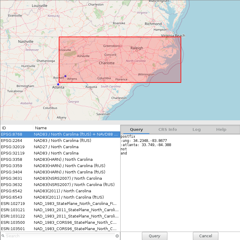
These equivalent commands find projections in US foot that contains 34.2348,-83.8677, but not 33.7490,-84.3880 in latlon:
# since the unit name "US foot" contains a space and statements are separated
# by whitespaces, it needs to be surrounded by single or double quotes when
# it's passed from the command line
g.projpicker query="postfix unit='US foot' 34.2348,-83.8677 33.7490,-84.3880 not and"

g.projpicker query="postfix unit='US foot' '34.2348 -83.8677' '33.7490 -84.3880' not and"

g.projpicker input=- <<EOT
postfix
unit=US foot    # in this case, quotes are optional because this statement is
                # not followed by other items
34.2348,-83.8677
33.7490,-84.3880
not
and
EOT

g.projpicker input=- <<EOT
postfix
unit=US foot
34.2348 -83.8677
33.7490 -84.3880
not
and
EOT

g.projpicker input=- <<EOT
postfix unit="US foot" 34.2348,-83.8677 33.7490,-84.3880 not and
EOT

g.projpicker input=- <<EOT
postfix
unit=US foot
A: 34.2348,-83.8677
B: 33.7490,-84.3880

:A :B not and
EOT
GUI
Start the GUI for selecting projections using the -g flag:g.projpicker -g query="postfix 34.2348,-83.8677 33.749,-84.388 not and"
AUTHOR
Huidae ChoSOURCE CODE
Available at: g.projpicker source code (history)
Latest change: Tuesday Aug 31 09:21:23 2021 in commit: b8c52758b3a592e68a4322668d1351cf383b97f7
Main index | General index | Topics index | Keywords index | Graphical index | Full index
© 2003-2023 GRASS Development Team, GRASS GIS 7.8.9dev Reference Manual