Note: This document is for an older version of GRASS GIS that has been discontinued. You should upgrade, and read the current manual page.
NAME
r.tpi - Calculates the multiscale topographic position indexKEYWORDS
rasterSYNOPSIS
Flags:
- --overwrite
- Allow output files to overwrite existing files
- --help
- Print usage summary
- --verbose
- Verbose module output
- --quiet
- Quiet module output
- --ui
- Force launching GUI dialog
Parameters:
- input=name [required]
- Elevation
- Input DEM from which to calculate mTPI
- minradius=integer [required]
- Smoothing neighborhood radius size (minimum)
- Minimum neighborhood radius in cells for DEM smoothing
- Default: 1
- maxradius=integer [required]
- Smoothing neighborhood radius size (maximum)
- Maximum neighborhood radius in cells for DEM smoothing
- Default: 31
- steps=integer [required]
- Number of scaling steps
- Number of steps to use for DEM generalization between minradius and maxradius
- Default: 5
- output=name [required]
- Multi-scale topographic position index
Table of contents
DESCRIPTION
r.tpicalculates a multiscale version of the Topographic Position Index (TPI) of Guisan et al. (1999). The TPI is calculated by averaging a DEM over a user-specified moving window size and subtracting the original DEM from the averaged version to get the residual. This has the effect of extracting finer-scale landforms from regional-scale relief. Positive TPI values represent ridges or hills, and negative TPI values represent valleys or pits.
Unlike the original TPI, r.tpi implements a multiscale version that calculates a standardized TPI over multiple neighborhood radii from minradius to maxradius, starting at the largest neighborhood size. For subsequent steps, the standardized TPI is updated with pixels where the absolute TPI values exceed the TPI values of the previous step. For large neighborhoods > 15, resampling is used rather than a focal function to generalize the DEM.
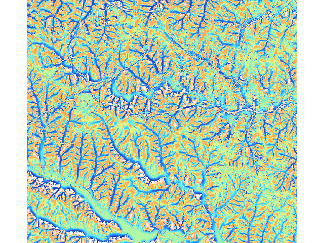
EXAMPLE
g.region raster=elevation@PERMANENT -a
r.tpi input=elevation@PERMANENT minradius=1 maxradius=25 steps=5 output=tpi
REFERENCES
Guisan, A., S. B. Weiss, A. D. Weiss 1999. GLM versus CCA spatial modeling of plant species distribution. Plant Ecology 143: 107-122SEE ALSO
r.mapcalc,AUTHOR
Steven PawleySOURCE CODE
Available at: r.tpi source code (history)
Latest change: Monday Jun 28 07:54:09 2021 in commit: 1cfc0af029a35a5d6c7dae5ca7204d0eb85dbc55
Main index | Raster index | Topics index | Keywords index | Graphical index | Full index
© 2003-2023 GRASS Development Team, GRASS GIS 7.8.9dev Reference Manual