Note: This document is for an older version of GRASS GIS that has been discontinued. You should upgrade, and read the current manual page.
NAME
v.clean - Toolset for cleaning topology of vector map.KEYWORDS
vector, topology, geometry, snappingSYNOPSIS
Flags:
- -b
- Do not build topology for the output vector
- -c
- Combine tools with recommended follow-up tools
- --overwrite
- Allow output files to overwrite existing files
- --help
- Print usage summary
- --verbose
- Verbose module output
- --quiet
- Quiet module output
- --ui
- Force launching GUI dialog
Parameters:
- input=name [required]
- Name of input vector map
- Or data source for direct OGR access
- layer=string
- Layer number or name ('-1' for all layers)
- A single vector map can be connected to multiple database tables. This number determines which table to use. When used with direct OGR access this is the layer name.
- Default: -1
- type=string[,string,...]
- Input feature type
- Options: point, line, boundary, centroid, area, face, kernel
- Default: point,line,boundary,centroid,area,face,kernel
- output=name [required]
- Name for output vector map
- error=name
- Name of output map where errors are written
- tool=string[,string,...] [required]
- Cleaning tool
- Options: break, snap, rmdangle, chdangle, rmbridge, chbridge, rmdupl, rmdac, bpol, prune, rmarea, rmline, rmsa
- break: break lines at each intersection
- snap: snap lines to vertex in threshold
- rmdangle: remove dangles, threshold ignored if < 0
- chdangle: change the type of boundary dangle to line, threshold ignored if < 0, input line type is ignored
- rmbridge: remove bridges connecting area and island or 2 islands
- chbridge: change the type of bridges connecting area and island or 2 islands from boundary to line
- rmdupl: remove duplicate geometry features (pay attention to categories!)
- rmdac: remove duplicate area centroids ('type' option ignored)
- bpol: break (topologically clean) polygons (imported from non topological format, like ShapeFile). Boundaries are broken on each point shared between 2 and more polygons where angles of segments are different
- prune: remove vertices in threshold from lines and boundaries, boundary is pruned only if topology is not damaged (new intersection, changed attachment of centroid), first and last segment of the boundary is never changed
- rmarea: remove small areas, the longest boundary with adjacent area is removed
- rmline: remove all lines or boundaries of zero length, threshold is ignored
- rmsa: remove small angles between lines at nodes
- threshold=float[,float,...]
- Threshold in map units, one value for each tool
- Default: 0.0[,0.0,...])
Table of contents
- DESCRIPTION
- Break lines/boundaries
- Remove duplicate geometry features
- Remove dangles or change boundary dangles to type line
- Remove or change bridges connecting an area and an island or two islands
- Snap lines to vertex in threshold
- Remove duplicate area centroids
- Break (topologically clean) areas (imported from a non topological format like ShapeFile)
- Remove vertices in threshold from lines and boundaries
- Remove small areas
- Remove all lines or boundaries of zero length
- Remove small angles between lines at nodes
- NOTES
- EXAMPLES
- SEE ALSO
- AUTHORS
DESCRIPTION
v.clean allows the user to automatically fix topology of vector maps. Several tools may be listed to be executed sequentially. In this case, also the threshold parameter requires several values to be listed accordingly. An error map is optionally written which stores the erroneous geometries.Break lines/boundaries
tool=breakThe break tool breaks lines/boundaries at intersections and it also breaks lines/boundaries forming a collapsed loop. For example, 0.0;1.0;0.0 is broken at 1.0.
Threshold does not apply (it is ignored), use an arbitrary value (e.g., 0) if v.clean is run with several tools.
Hint: Breaking lines should be followed by removing duplicates, e.g. v.clean ... tool=break,rmdupl. If the -c flag is used with v.clean ... tool=break, duplicates are automatically removed.
Remove duplicate geometry features
tool=rmduplThe rmdupl tool removes geometry features with identical coordinates. Categories are merged. If a point and a centroid have identical coordinates, one of them will be removed if both points and centroids are selected with v.clean ... type=point,centroid. The same applies for lines and boundaries.
Threshold does not apply (it is ignored), use an arbitrary value (e.g., 0) if v.clean is run with several tools.
The rmdupl tool should be used after breaking lines and breaking polygons.
Remove dangles or change boundary dangles to type line
tool=rmdangle and tool=chdangleA line/boundary is considered to be a dangle if no other line of given type is on at least one end node. If a dangle is formed by several lines, such a string of lines is taken as one dangle and line lengths are summarized. The rmdangle tool deletes a dangle if the (combined) length is shorter than thresh or thresh < 0. If the combined length is larger than thresh, nothing is deleted.
Threshold has to be given as maximum line/boundary length in map units; for latitude-longitude locations in degree. Dangles shorter than thresh are removed sequentially. All dangles will be removed if thresh < 0.
With thresh < 0, only closed loops and lines connecting loops will remain. This is useful to remove all incorrect boundaries after other cleaning operations with thres is < 0. Areas can then be successfully built.
To preferentially remove shortest dangles first, a first pass with a small thresh value can be followed by subsequent passes with higher thresh values. This can be done as one v.clean job by listing the tool several times and by defining a list of increasing thresh values.
The chdangle tool is similar to the rmdangle tool, but works only on boundaries and changes dangling boundaries to lines instead of removing them.
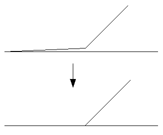
Remove or change bridges connecting an area and an island or two islands
tool=rmbridge and tool=chbridgeA bridge is an area type connection of an island (polygon in a polygon) to the outer polygon. This is topologically incorrect (but OGC Simple Features allow it). The rmbridge tool removes bridges and the chbridge tool changes bridges to type line:
    +-------------+             +-------------+   +-------------+
    |            P|  P: polygon |            P|   |            P|
    |    +---+    |  I: island  |    +---+    |   |    +---+    |
    |    | I |    |  B: bridge  |    | I |    |   |    | I |    |
    |    |   |    |  L: line    |    |   |    |   |    |   |    |
    |    +-+-+    |             |    +---+    |   |    +-.-+    |
    |      |      |             |             |   |      .      |
    |      | B    |             |             |   |      . L    |
    |      |      |             |             |   |      .      |
    +------+------+             +-------------+   +-------------+
Islands and areas must be already clean, i.e. without dangles or small angles, e.g. v.clean ... type=boundary tool=rmdangle,rmsa,break,rmdupl,rmbridge thresh=-1,0,0,0,0.
Threshold does not apply (it is ignored), use an arbitrary value (e.g., 0) if v.clean is run with several tools.
Snap lines to vertex in threshold
tool=snapThe snap tool snaps vertices to another vertex not farther away than thresh. If there is no other vertex within thresh, no snapping will be done. The type option can have a strong influence on the result. A too large threshold and type=boundary can severely damage area topology, beyond repair.
Threshold gives maximum distance to another vertex in map units, for latitude-longitude locations in degree.
Snapped boundaries may need to be cleaned with break,rmdupl,rmsa. If the -c flag is used with v.clean tool=snap, the sequence of break,rmdupl,rmsa is automatically repeated after snapping until no more small angles a left. Additional cleaning with e.g. tool=rmdanglemay be necessary.
Remove duplicate area centroids
tool=rmdacThe rmdac tool removes duplicate area centroids that can result from deleting boundaries.
Threshold does not apply (it is ignored), use an arbitrary value (e.g., 0) if v.clean is run with several tools.
Break (topologically clean) areas (imported from a non topological format like ShapeFile)
tool=bpolThe bpol tool breaks boundaries on each point shared between 2 and more areas where angles of boundary segments are different and on all boundary nodes (start and end points of each boundary). The bpol tool behaves similar to break for boundaries, but does not break collapsed loops. The bpol tool is faster than the break tool but needs more memory.
Threshold does not apply (it is ignored), use an arbitrary value (e.g., 0) if v.clean is run with several tools.
The bpol tool should be followed by rmdupl. If the -c flag is used with v.clean ... tool=bpol, duplicates are automatically removed.
Remove vertices in threshold from lines and boundaries
tool=pruneThe prune tool simplifies lines and boundaries by removing vertices according to threshold. This tool preserves area topology, areas are never deleted and centroid attachment is never changed. v.generalize offers much more functionality for line simplification but does not preserve area topology.
Remove small areas
tool=rmareaThe rmarea tool removes all areas <= thresh. The longest boundary with an adjacent area is removed or all boundaries if there is no adjacent area. Area categories are not combined when a small area is merged with a larger area.
Threshold must always be in square meters, also for latitude-longitude locations or locations with units other than meters.
Remove all lines or boundaries of zero length
tool=rmlineThe rmline tool removes all lines or boundaries of zero length that may have resulted from other cleaning operations. Zero length boundaries are redundant and do not influence area topology.
Threshold does not apply (it is ignored), use an arbitrary value (e.g., 0) if v.clean is run with several tools.
Remove small angles between lines at nodes
tool=rmsaThe rmsa tool only concerns angles which are so small that the calculated angle is 0. The following figure should help demonstrate what the tool does.
Threshold does not apply, use dummy value if v.clean is run with several tools.
|
| tool=rmsa |
The rmsa tool should be followed by break,rmdupl. The rmsa tool followed by break,rmdupl may need to be run more than once to remove all small angles. If the -c flag is used with v.clean ... tool=rmsa, the sequence of rmsa,break,rmdupl is automatically repeated until no more small angles a left.
NOTES
The user does not have to run v.build on the output vector, unless the -b flag was used. The -b flag affects only the output vector - topology is always built for error vector.EXAMPLES
Snap lines to vertex in threshold
v.clean input=testmap output=cleanmap tool=snap threshold=1
Inspecting the topological errors visually
Both v.build and v.clean can collect the topological errors into a vector map:v.build -e map=imported error=build_errors v.clean -c input=imported output=clean error=cleaning_errors tool=snap,rmdangle,rmbridge,chbridge,bpol,prune threshold=5
d.vect map=imported color=26:26:26 fill_color=77:77:77 width=5
d.vect map=build_errors color=255:33:36 fill_color=none width=5 icon=basic/point size=30
d.vect map=cleaning_errors color=255:33:36 fill_color=none width=5 icon=basic/point size=30
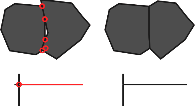
Figure: Topological errors detected in the original data (left) and cleaned data (right)
Cleaning OGR imported data (Simple Feature data) such as SHAPE file
The import of areas with v.in.ogr -c (no cleaning) requires a subsequent run of v.clean to update the map to a topologically valid structure (removal of duplicate collinear lines etc). The tools used for that are bpol and rmdupl:v.clean input=areamap output=areamap_clean tool=bpol,rmdupl type=boundary
Extracting intersection points of vector lines
v.clean input=lines1 output=lines2 err=points tool=break type=line
Break lines
v.clean will break the lines where they cross, creating new node if needed. Example:
v.in.ascii -n out=crossed_lines format=standard << EOF
L 2
 0 5
 10 5
L 2
 5 0
 5 10
EOF

v.clean in=crossed_lines out=crossed_lines_brk \
        error=intersection tool=break type=line
Remove all lines of zero length
v.out.ascii zero format=standard
L  2 1
 -819832.09065589 -987825.2187231
 -806227.28362601 -971104.80702988
 1     1
L  2 1
 -799165.24638913 -972974.16982788
 -799165.24638913 -972974.16982788
 1     2

v.clean input=zero output=zero_clean tool=rmline type=line

v.out.ascii zero_clean format=standard
L  2 1
 -819832.09065589 -987825.2187231
 -806227.28362601 -971104.80702988
 1     1
Repeatedly remove dangling lines up to 50m length
v.clean input=testmap output=cleanmap type=line \
        tool=rmdangle,rmdangle,rmdangle,rmdangle threshold=5,10,20,50
SEE ALSO
v.info, v.build, g.gui.vdigit, v.edit, v.generalizeAUTHORS
David Gerdes, U.S. Army Construction Engineering Research LaboratoryRadim Blazek, ITC-irst, Trento, Italy
Martin Landa, FBK-irst (formerly ITC-irst), Trento, Italy
SOURCE CODE
Available at: v.clean source code (history)
Latest change: Monday Nov 18 20:15:32 2019 in commit: 1a1d107e4f6e1b846f9841c2c6fabf015c5f720d
Main index | Vector index | Topics index | Keywords index | Graphical index | Full index
© 2003-2023 GRASS Development Team, GRASS GIS 7.8.9dev Reference Manual