r.sample.category
Create sampling points from each category in a raster map
r.sample.category [-s] input=name output=name [sampled=name [,name,...]] npoints=integer [,integer,...] [random_seed=integer] [--overwrite] [--verbose] [--quiet] [--qq] [--ui]
Example:
r.sample.category input=name output=name npoints=0
grass.tools.Tools.r_sample_category(input, output, sampled=None, npoints, random_seed=None, flags=None, overwrite=None, verbose=None, quiet=None, superquiet=None)
Example:
tools = Tools()
tools.r_sample_category(input="name", output="name", npoints=0)
This grass.tools API is experimental in version 8.5 and expected to be stable in version 8.6.
grass.script.run_command("r.sample.category", input, output, sampled=None, npoints, random_seed=None, flags=None, overwrite=None, verbose=None, quiet=None, superquiet=None)
Example:
gs.run_command("r.sample.category", input="name", output="name", npoints=0)
Parameters
input=name [required]
Name of input raster map with categories (classes)
output=name [required]
Name of output vector map with points at random locations
sampled=name [,name,...]
Names of input raster maps to be sampled
npoints=integer [,integer,...] [required]
Number of sampling points per category in the input map
You can provide multiple numbers, one for each category in input raster (sorted ascending)
random_seed=integer
Seed for random number generator
-s
If number of cells in category < npoints, skip category
--overwrite
Allow output files to overwrite existing files
--help
Print usage summary
--verbose
Verbose module output
--quiet
Quiet module output
--qq
Very quiet module output
--ui
Force launching GUI dialog
input : str | np.ndarray, required
Name of input raster map with categories (classes)
Used as: input, raster, name
output : str, required
Name of output vector map with points at random locations
Used as: output, vector, name
sampled : str | list[str], optional
Names of input raster maps to be sampled
Used as: input, raster, name
npoints : int | list[int] | str, required
Number of sampling points per category in the input map
You can provide multiple numbers, one for each category in input raster (sorted ascending)
random_seed : int, optional
Seed for random number generator
flags : str, optional
Allowed values: s
s
If number of cells in category < npoints, skip category
overwrite : bool, optional
Allow output files to overwrite existing files
Default: None
verbose : bool, optional
Verbose module output
Default: None
quiet : bool, optional
Quiet module output
Default: None
superquiet : bool, optional
Very quiet module output
Default: None
Returns:
result : grass.tools.support.ToolResult | None
If the tool produces text as standard output, a ToolResult object will be returned. Otherwise, None will be returned.
Raises:
grass.tools.ToolError: When the tool ended with an error.
input : str, required
Name of input raster map with categories (classes)
Used as: input, raster, name
output : str, required
Name of output vector map with points at random locations
Used as: output, vector, name
sampled : str | list[str], optional
Names of input raster maps to be sampled
Used as: input, raster, name
npoints : int | list[int] | str, required
Number of sampling points per category in the input map
You can provide multiple numbers, one for each category in input raster (sorted ascending)
random_seed : int, optional
Seed for random number generator
flags : str, optional
Allowed values: s
s
If number of cells in category < npoints, skip category
overwrite : bool, optional
Allow output files to overwrite existing files
Default: None
verbose : bool, optional
Verbose module output
Default: None
quiet : bool, optional
Quiet module output
Default: None
superquiet : bool, optional
Very quiet module output
Default: None
DESCRIPTION
r.sample.category generates points at random locations. Each category (class) in a raster map will contain specified number of random points.
Different number of points can be specified for different categories. For example, if there are categories 1, 4, 7 in the input raster map, and npoints=100,200,300, 100 points will be generated in category 1, 200 points in category 4 and 300 points in category 7. If only one number is specified, it will be used for every category.
NOTES
Mask (r.mask) to create points in areas with each category, thus mask cannot be active when the module is used.
Categories are identified based on current computational region.
EXAMPLE
Generate random points
Generate three points at random location for each category (class) in the raster map:
g.region raster=landclass96
r.sample.category input=landclass96 output=landclass_points npoints=3
Show the result:
d.rast map=landclass96
d.vect map=landclass_points icon=basic/circle fill_color=aqua color=blue size=10
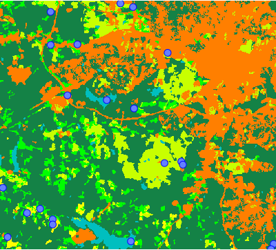
Figure: Three random points in each category of landclass raster map
Create a table with values sampled from rasters
Create 2 random points per each category (class) in landclass96 raster and sample elevation and geology_30m rasters at these points:
r.sample.category input=landclass96 output=landclass_points sampled=elevation,geology_30m npoints=2
Look at the created data:
v.db.select landclass_points sep=comma
The result of v.db.select is CSV table which can be used, for example in a spreadsheet application:
cat,landclass96,elevation,geology_30m
1,1,102.7855,270
2,1,105.78,270
3,2,114.5954,217
4,2,137.4816,921
5,3,71.19167,270
6,3,93.33904,270
7,4,76.41077,262
8,4,97.54424,217
9,5,138.455,405
10,5,88.8075,270
11,6,126.5298,217
12,6,86.73177,217
13,7,134.5381,217
14,7,99.6844,270
SEE ALSO
v.sample, r.random, r.random.cells, v.random, v.what.rast, r.describe
AUTHORS
Vaclav Petras, NCSU OSGeoREL,
Anna Petrasova, NCSU OSGeoREL
SOURCE CODE
Available at: r.sample.category source code
(history)
Latest change: Wednesday Mar 11 08:17:30 2026 in commit 2a14bbb