NAME
r.in.nasadem - Creates a DEM from 1 arcsec NASADEM tiles.KEYWORDS
raster, import, SRTMSYNOPSIS
Flags:
- -z
- Create zero elevation for missing tiles
- --overwrite
- Allow output files to overwrite existing files
- --help
- Print usage summary
- --verbose
- Verbose module output
- --quiet
- Quiet module output
- --ui
- Force launching GUI dialog
Parameters:
- version=string
- NASADEM version
- Options: NASADEM_HGT.001
- Default: NASADEM_HGT.001
- layer=string
- NASADEM layer to import
- Options: hgt, num, swb
- Default: hgt
- hgt: Void-filled DEM
- num: Number of scenes
- swb: Updated SRTM water body data
- output=name [required]
- Name for output raster map
- username=string
- Username for authentication
- password=string
- Password for authentication
- url=string
- Base URL to fetch NASADEM tiles
- Default: https://e4ftl01.cr.usgs.gov/MEASURES
- local=name
- Local folder with NASADEM tiles
- Use local folder instead of URL to retrieve NASADEM tiles
- region=xmin,ymin,xmax,ymax
- Import subregion only (default is current region)
- Format: xmin,ymin,xmax,ymax - usually W,S,E,N
- method=string
- Resampling method to use for reprojection (required if location projection not longlat)
- Options: nearest, bilinear, bicubic, lanczos, bilinear_f, bicubic_f, lanczos_f
- Default: bilinear_f
- nearest: nearest neighbor
- bilinear: bilinear interpolation
- bicubic: bicubic interpolation
- lanczos: lanczos filter
- bilinear_f: bilinear interpolation with fallback
- bicubic_f: bicubic interpolation with fallback
- lanczos_f: lanczos filter with fallback
- resolution=float
- Resolution of output raster map (required if location projection not longlat)
- memory=integer
- Maximum memory to be used (in MB)
- Cache size for raster rows
- Default: 300
Table of contents
DESCRIPTION
r.in.nasadem imports all NASADEM tiles covering the current region or region extents given with the region option into GRASS and patches the tiles together.Cited from https://lpdaac.usgs.gov/news/release-nasadem-data-products/:
"NASADEM extends the legacy of the Shuttle Radar Topography Mission (SRTM) by improving the digital elevation model (DEM) height accuracy and data coverage as well as providing additional SRTM radar-related data products. The improvements were achieved by reprocessing the original SRTM radar signal data and telemetry data with updated algorithms and auxiliary data not available at the time of the original SRTM processing."
In total, 14,520 NASADEM tiles are available.
r.in.nasadem imports data from NASADEM_HGT.001, or from a local copy of these data provided with the local option.
There are three different layers available in the NASADEM_HGT.001 product: hgt, num, and swb, each of these layers can be imported with r.in.nasadem with the layer option. Importantly, for the NASADEM tiles download a user registration is needed at https://urs.earthdata.nasa.gov/users/new
In the earthdata user profile, two specific applications must be approved in the "My application" tab:
- "LP DAAC Data Pool" application, and
- "Earthdata Search" application.
EXAMPLE
Import of NASADEM_HGT.001 covering the current computational region:# run in LatLong location - Sicily East, Italy g.region n=39 s=37 w=14 e=16 res=0:00:01 -p # use own credentials here r.in.nasadem user="my_nasa_user" password="my_nasa_pw" output=nasadem_sicily_1arc memory=2000 r.univar nasadem_sicily_1arc
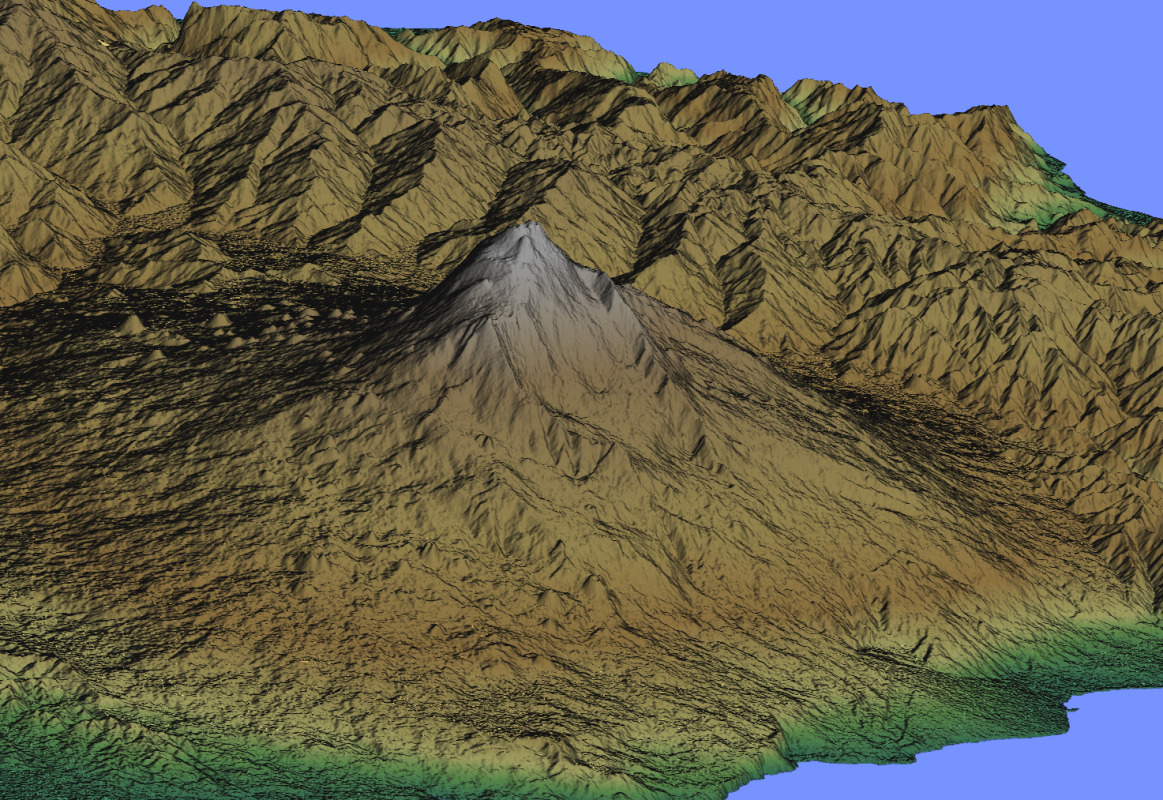
Figure: Eta volcano (Sicily, Italy) shown in NVIZ
SEE ALSO
r.in.srtm, r.in.srtm.regionThe Shuttle Radar Topography Mission homepage at NASA's JPL (see also MEaSUREs Data Product Table - SRTM).
The NASADEM_HGT.001 product page.
REFERENCES
M. Neteler, 2005. SRTM and VMAP0 data in OGR and GRASS. GRASS Newsletter, Vol.3, pp. 2-6, June 2005. ISSN 1614-8746.AUTHORS
Markus MetzReprojection support: Anika Bettge, mundialis
SOURCE CODE
Available at: r.in.nasadem source code (history)
Latest change: Thu Feb 3 09:32:35 2022 in commit: f17c792f5de56c64ecfbe63ec315307872cf9d5c
Main index | Raster index | Topics index | Keywords index | Graphical index | Full index
© 2003-2022 GRASS Development Team, GRASS GIS 8.0.3dev Reference Manual