NAME
r.surf.fractal - Creates a fractal surface of a given fractal dimension.KEYWORDS
raster, surface, fractalSYNOPSIS
r.surf.fractal
r.surf.fractal --helpr.surf.fractal output=name [dimension=float] [number=integer] [--overwrite] [--help] [--verbose] [--quiet] [--ui]
Flags:
- --overwrite
- Allow output files to overwrite existing files
- --help
- Print usage summary
- --verbose
- Verbose module output
- --quiet
- Quiet module output
- --ui
- Force launching GUI dialog
Parameters:
- output=name [required]
- Name for output raster map
- dimension=float
- Fractal dimension of surface (2 < D < 3)
- Default: 2.05
- number=integer
- Number of intermediate images to produce
- Default: 0
Table of contents
DESCRIPTION
r.surf.fractal creates a fractal surface of a given fractal dimension. It uses the spectral synthesis method. The module can create intermediate layers showing the build up of different spectral coefficients (see Saupe, pp.106-107 for an example of this).This module generates naturally looking synthetical elevation models (DEM).
NOTE
This module requires the FFTW library for computing Discrete Fourier Transforms.EXAMPLE
Generate surface using fractals in selected region, set color table and display with shade.g.region -p raster=elevation r.surf.fractal output=fractals r.colors map=fractals color=byr r.relief input=fractals output=fractals_shade d.mon wx0 d.shade shade=fractals_shade color=fractals b=50
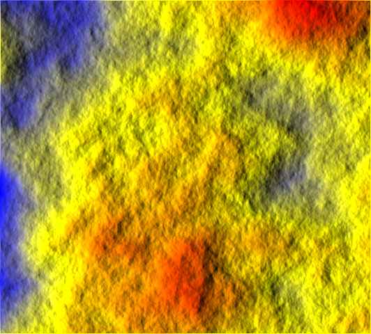
Artificial surface created with fractals
# D=2.0005
g.region -dp
r.surf.fractal out=dem_d2_0005 dim=2.0005
r.info -r dem_d2_0005
r.mapcalc "dem_d2_0005_final = 1.0 * dem_d2_0005 + abs(min(dem_d2_0005))"
r.colors dem_d2_0005_final color=terrain
r.slope.aspect dem_d2_0005_final aspect=dem_d2_0005_final_as

# D=2.90
r.surf.fractal out=dem_d2_90 dim=2.90
r.info -r dem_d2_90
r.mapcalc "dem_d2_90_final = 1.0 * dem_d2_90 + abs(min(dem_d2_90))"
r.colors dem_d2_90_final color=terrain
r.slope.aspect dem_d2_90_final aspect=dem_d2_90_final_as
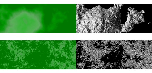
Artificial DEMs created with fractals:
top: fractal dimension d=2.0005 (left: elevation map, right: aspect map)
top: fractal dimension d=2.90 (left: elevation map, right: aspect map)
REFERENCES
Saupe, D. (1988) Algorithms for random fractals, in Barnsley M., Devaney R., Mandelbrot B., Peitgen, H-O., Saupe D., and Voss R. (1988) The Science of Fractal Images, Ch. 2, pp.71-136. London: Springer-Verlag.SEE ALSO
r.surf.contour, r.surf.idw, r.surf.gauss, r.surf.random, v.surf.idw, v.surf.rstAUTHOR
Jo Wood, Midlands Regional Research Laboratory (ASSIST), University of LeicesterSOURCE CODE
Available at: r.surf.fractal source code (history)
Latest change: Thu Feb 3 11:10:06 2022 in commit: 73413160a81ed43e7a5ca0dc16f0b56e450e9fef
Main index | Raster index | Topics index | Keywords index | Graphical index | Full index
© 2003-2022 GRASS Development Team, GRASS GIS 8.0.3dev Reference Manual